 W
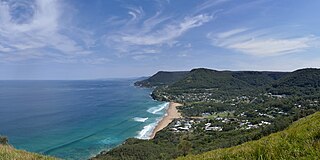
WBald Hill is a hill on the Illawarra Range, in the state of New South Wales, Australia. With an elevation of approximately 300 metres (980 ft) AMSL, Bald Hill is one of the best known and most popular lookouts in the Illawarra region providing panoramic vistas across the Illawarra escarpment and over the Illawarra plain and the Tasman Sea of the South Pacific Ocean.
 W
WBrown Wardle is a hill between the village of Wardle, Greater Manchester and the town of Whitworth, Lancashire, England. The summit is on the border of Greater Manchester and Lancashire and stands 400 m (1,312 ft) above sea level, making it one of the highest points in Rochdale and Greater Manchester. It forms part of the South Pennines, lying within the historic county boundaries of Lancashire.
 W
WMount Diablo is a mountain of the Diablo Range, in Contra Costa County of the eastern San Francisco Bay Area in Northern California. It is south of Clayton and northeast of Danville. It is an isolated upthrust peak of 3,849 feet, visible from most of the San Francisco Bay Area. Mount Diablo appears from many angles to be a double pyramid and has many subsidiary peaks, the largest and closest of which is the other half of the double pyramid, North Peak, nearly as high in elevation at 3,557 feet (1,084 m), and is about one mile northeast of the main summit.
 W
WEd R. Levin County Park is the largest park in Milpitas, California. It is run by the Santa Clara County Parks and Recreation Department and is located in the chaparral foothills of Diablo Range east of the Santa Clara Valley. Monument Peak can be accessed through trails in the park. The park's recreational facilities include a hang gliding and paragliding area, a dog park, and horseback riding areas. Ed R. Levin County Park has two lakes, Sandy Wool Lake and Spring Valley Pond. Both of them are reservoirs which collect runoff water from the hills to the east. It is home to some of the East Bay Walls.
 W
WFort Funston is a former harbor defense installation located in the southwestern corner of San Francisco. Formerly known as the Lake Merced Military Reservation, the fort is now a protected area within the Golden Gate National Recreation Area (GGNRA). It was named in honor of Frederick N. Funston (1865–1917), a Major General in the United States Army with strong connections to San Francisco, and included several artillery batteries. The fort is located on Skyline Boulevard at John Muir Drive, west of Lake Merced.
 W
WGoat Rock Beach is a sand beach in northwestern Sonoma County, California, United States. This landform is a sub-unit of Sonoma Coast State Beach, owned and managed by the State of California. At the northern terminus of Goat Rock Beach is the mouth of the Russian River, and the southern end of this crescent shaped expanse is the massive Goat Rock, an iconic outcrop of the Sonoma Coast, which is barely attached to the mainland by a narrow isthmus.
 W
WHat Creek is a 48.7-mile-long (78.4 km) stream and tributary of the Pit River, located in Shasta County of northern California.
 W
WLake McClure is a reservoir in the Sierra Nevada foothills of western Mariposa County, California.
 W
WLake Pillsbury is a lake in the Mendocino National Forest of Lake County, California, created from the Eel River and Hull Mountain watershed by Scott Dam. Elevation is 1,818 ft (554 m) with 65 mi (105 km) of shoreline and covering 2,003 acres (811 ha). Activities in the Lake Pillsbury Recreation Area include powerboating, fishing, swimming, sailing, picnicking, hiking and hang gliding. There are two main access roads to the lake. At the north end of the lake is a small gravel airstrip. Over 400 homes including National Forest Recreational Residences ring this beautiful recreational lake.
 W
WMarina State Beach is a protected beach on Monterey Bay, located in the city of Marina in Monterey County, California.
 W
WMount Tamalpais is a peak in Marin County, California, United States, often considered symbolic of Marin County. Much of Mount Tamalpais is protected within public lands such as Mount Tamalpais State Park, the Marin Municipal Water District watershed, and National Park Service land, such as Muir Woods.