 W
WWater trails are marked routes on navigable waterway such as rivers, lakes, canals and coastlines for recreational use. They allow access to waterways for non-motorized boats and sometimes motorized vessels, innertubes, and other craft. Water trails not only require suitable access points and take-outs for exit but also provide places ashore to camp and picnic, and other facilities for boaters.
 W
WThe Alabama Scenic River Trail (ASRT) is a water trail that spans the state of Alabama. The trail starts in northeast Alabama on the Coosa River's Weiss Lake at the Georgia-Alabama state line and ends at Fort Morgan, Alabama, where Mobile Bay meets the Gulf of Mexico. It comprises sections of the Coosa, Tallapoosa, Alabama, and Mobile rivers.
 W
WThe Allagash Wilderness Waterway is a 92.5-mile-long (148.9 km) protected area extending from Aroostook County, Maine into Piscataquis County, Maine. It is a ribbon of lakes, ponds, rivers, and streams of the Maine North Woods that includes much of the Allagash River. Canoeing, fishing, hunting, and camping are among the activities permitted.
 W
WThe Blue Earth River is a tributary of the Minnesota River, 108 miles (174 km) long, in southern Minnesota in the United States. Two of its headwaters tributaries, the Middle Branch Blue Earth River and the West Branch Blue Earth River, also flow for short distances in northern Iowa. By volume, it is the Minnesota River's largest tributary, accounting for 46% of the Minnesota's flow at the rivers' confluence in Mankato. Via the Minnesota River, the Blue Earth River is part of the watershed of the Mississippi River, draining an area of 3,486 square miles (9,029 km²) in an agricultural region. Ninety percent of the river's watershed is in Minnesota. It is a Minnesota Department of Natural Resources designated Water Trail.
 W
WThe Captain John Smith Chesapeake National Historic Trail is a series of water routes in the United States extending approximately 3,000 miles (4,800 km) along the Chesapeake Bay, the nation's largest estuary, and its tributaries in Virginia, Maryland, Delaware, and in the District of Columbia. The historic routes trace the 1607–1609 voyages of Captain John Smith to chart the land and waterways of the Chesapeake. Along with the Star-Spangled Banner National Historic Trail, it is one of two water trails designated as National Historic Trails.
 W
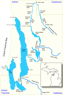
WThe Elk River Chain of Lakes Watershed is a 75-mile-long (121 km) waterway consisting of 14 lakes and connecting rivers in the northwestern section of the Lower Peninsula of the U.S. state of Michigan, which empty into Lake Michigan.
 W
WThe French Broad River flows 218 miles (351 km) from near the town of Rosman in Transylvania County, North Carolina, into the state of Tennessee. Its confluence with the Holston River at Knoxville is the beginning of the Tennessee River. The river flows through the counties of Transylvania, Buncombe, Henderson, and Madison in North Carolina, and Cocke, Jefferson, Sevier, and Knox in Tennessee. It drains large portions of the Pisgah National Forest and the Cherokee National Forest.
 W
WThe Great Calusa Blueway is a paddling trail in Florida for kayakers, canoers, paddle boarders and other paddlers. It covers 190 miles meandering through the coastal waters and inland tributaries of Lee County, Florida. The Calusa Blueway Paddling Festival is held to celebrate the trail.
 W
WHammocks Beach State Park is a North Carolina state park in Onslow County, North Carolina in the United States. Located near Swansboro, along the Southern Outer Banks, or Crystal Coast, the state park covers 1,611 acres (6.52 km2) and consists mainly of Bear Island. The park also owns three smaller islands, Dudley, Huggins and Jones, located in the nearby mouth of the White Oak River. After a recently completed deal, 319 acres (1.29 km2) acres on the mainland were added to the park.
 W
WThe Inland Waterway or Inland Water Route is a 38-mile-long (61 km) series of rivers and lakes in the U.S. state of Michigan. With only a short portage, it forms a navigable route for small craft connecting Lake Huron and Crooked Lake, across the Northern Michigan region. Despite Little Traverse Bay being only 2 miles west of Crooked Lake, the waterway does not connect to it, making Lake Michigan inaccessible through this route.
 W
WThe Keweenaw Waterway is a partly natural, partly artificial waterway which cuts across the Keweenaw Peninsula of Michigan; it separates Copper Island from the mainland. Parts of the waterway are variously known as the Keweenaw Waterway, Portage Canal, Portage Lake Canal, Portage River, Lily Pond, Torch Lake, and Portage Lake. The waterway connects to Lake Superior at its north and south entries, with sections known as Portage Lake and Torch Lake in between. The primary tributary to Portage Lake is the Sturgeon River.
 W
WThe Maine Island Trail is a recreational water trail that spans the entire coast of Maine, connecting over 200 islands and mainland sites available for day visits or overnight camping. The trail is operated by the Maine Island Trail Association (MITA), a non-profit membership organization based in Portland, Maine with over 6000 members. Trail properties are owned by private landowners, conservation organizations, and federal, state and municipal agencies, all of whom make their land available to MITA members in exchange for Leave No Trace use and careful stewardship. All sites are accessible by personal watercraft, such as sea kayaks, sailboats or powerboats.
 W
WMedoc Mountain State Park is a 3,893-acre (15.75 km2) North Carolina state park in Halifax County, North Carolina in the United States. It is near Hollister, North Carolina in eastern North Carolina and includes the 325 foot peak Medoc Mountain.
 W
WMerchants Millpond State Park is a North Carolina state park in Gates County, North Carolina, in the United States. Located near Gatesville, in North Carolina's coastal plain, it covers 3,520 acres (14.2 km2) around a 200-year-old, 700-acre (280 ha) millpond and Lassiter Swamp. Canoeing is one of the park's major attractions. Alligators live in its large cypress swamps.
 W
WThe Nanticoke River is a tributary of the Chesapeake Bay on the Delmarva Peninsula. It rises in southern Kent County, Delaware, flows through Sussex County, Delaware, and forms the boundary between Dorchester County, Maryland and Wicomico County, Maryland. The tidal river course proceeds southwest into the Tangier Sound, Chesapeake Bay. The river is 64.3 miles (103.5 km) long. A 26-mile ecotourism water trail running along the River was set aside in July 2011 by Delaware state and federal officials, contiguous with a 37-mile water-trail extending through Maryland to the Chesapeake Bay.
 W
WThe Ohio River Trail (ORT) is composed of two entities, the Ohio River Water Trail and the Ohio River Greenway Trail. The Ohio River Greenway Trail is a proposed route that would interconnect existing trails in Maryland, Pennsylvania, Ohio and West Virginia. The proposal is spearheaded by the Ohio River Trail Council (ORTC), a volunteer-led, non-profit organization. The ORTC is an Internal Revenue Service registered 501(c)(3) not-for-profit organization which relies on corporate, foundation, government, and private grants and donations to achieve its stated mission of creating a multi-use trail along the Ohio River and its tributaries. The Council is headquartered in Monaca, Pennsylvania.
 W
WThe San Francisco Bay Area Water Trail is a growing network of launch and landing sites that allow people in non-motorized small boats and beachable sail craft such as kayaks, canoes, dragon boats, stand up paddle and windsurf boards, to safely enjoy San Francisco Bay through single and multiple-day trips. The Water Trail is enhancing Bay Area communities’ connections to the Bay and creating new linkages to existing shoreline open spaces and other regional trails as well as increasing education about personal safety, navigational safety, and appropriate boating behavior near sensitive wildlife species and shoreline habitat. The Water Trail is implemented under the leadership of the California Coastal Conservancy in close collaboration with the Association of Bay Area Governments, the San Francisco Bay Conservation and Development Commission, and the California Department of Boating and Waterways.
 W
WThe Shiawassee River Heritage Water Trail started as a 7 miles (11 km) water trail in the Shiawassee River, within Genesee County and Oakland County, Metro Detroit, southeastern Michigan. It now reaches 85.5 85.5 miles (137.6 km) from Holly to Chesaning in Saginaw County.
 W
WThe Yadkin River is one of the longest rivers in North Carolina, flowing 215 miles (346 km). It rises in the northwestern portion of the state near the Blue Ridge Parkway's Thunder Hill Overlook. Several parts of the river are impounded by dams for water, power, and flood control. The river becomes the Pee Dee River at the confluence of the Uwharrie River south of the community of Badin and east of the town of Albemarle. The river then flows into South Carolina near Cheraw, which is at the Fall Line. The entirety of the Yadkin River and the Great Pee Dee River is part of the Yadkin-Pee Dee River Basin.