 W
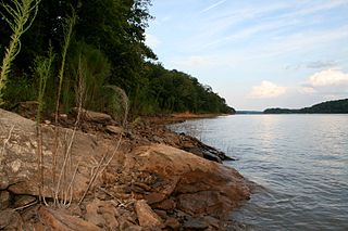
WAquadoctan was one of the largest known Native American villages in what is now the U.S. state of New Hampshire. In an area commonly known today as The Weirs, the village lay on the north bank of the Winnipesaukee River at the outlet of Lake Winnipesaukee in the Lakes Region of New Hampshire. The site is now in Weirs Beach, a summer resort and village of the city of Laconia. The Native American village, whose archaeological remains extend for a half mile along the river and a quarter mile along the lake, has been documented through archaeological investigation to have evidence of settlement from 9,000 BCE to the late seventeenth century. Colonial reports document that the site was abandoned substantially in 1696, when most of New Hampshire's remaining native population withdrew to join the Pequawket at present-day Fryeburg, Maine.
 W
WBig Mound City (8PB48) is a prehistoric site near Canal Point, Florida, United States. It is located 10 miles east of Canal Point, off U.S. Route 98. On May 24, 1973, it was added to the U.S. National Register of Historic Places. It is located inside the J.W. Corbett Wildlife Management Area.
 W
WThe Cahokia Mounds State Historic Site is the site of a pre-Columbian Native American city directly across the Mississippi River from modern St. Louis, Missouri. This historic park lies in south-western Illinois between East St. Louis and Collinsville. The park covers 2,200 acres (890 ha), or about 3.5 square miles (9 km2), and contains about 80 mounds, but the ancient city was much larger. At its apex around 1100 CE, the city covered about 6 square miles (16 km2) and included about 120 manmade earthen mounds in a wide range of sizes, shapes, and functions. At the apex of its population, Cahokia may have briefly exceeded contemporaneous London, which at that time was approximately 14,000–18,000.
 W
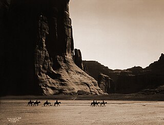
WCanyon de Chelly National Monument was established on April 1, 1931, as a unit of the National Park Service. Located in northeastern Arizona, it is within the boundaries of the Navajo Nation and lies in the Four Corners region. Reflecting one of the longest continuously inhabited landscapes of North America, it preserves ruins of the indigenous tribes that lived in the area, from the Ancestral Puebloans to the Navajo. The monument covers 83,840 acres and encompasses the floors and rims of the three major canyons: de Chelly, del Muerto, and Monument. These canyons were cut by streams with headwaters in the Chuska Mountains just to the east of the monument. None of the land is federally owned. Canyon de Chelly is one of the most visited national monuments in the United States.
 W
WCasamero Pueblo is an archaeological site including the partially excavated and stabilized ruins of an 11th-century Ancestral Puebloan community in Prewitt, New Mexico in McKinley County. It was an outlier of Chaco Canyon. It is on the Trail of the Ancients Scenic Byway.
 W
WChaco Culture National Historical Park is a United States National Historical Park in the American Southwest hosting a concentration of pueblos. The park is located in northwestern New Mexico, between Albuquerque and Farmington, in a remote canyon cut by the Chaco Wash. Containing the most sweeping collection of ancient ruins north of Mexico, the park preserves one of the most important pre-Columbian cultural and historical areas in the United States.
 W
WEtowah Indian Mounds (9BR1) are a 54-acre (220,000 m2) archaeological site in Bartow County, Georgia south of Cartersville, in the United States. Built and occupied in three phases, from 1000–1550 AD, the prehistoric site is located on the north shore of the Etowah River.
 W
WKanadaseaga, was a major village, perhaps a capital, of the Seneca nation of the Iroquois Confederacy in west-central New York State, United States. It was located between the northern ends of Seneca and Canandaigua lakes, one and a half miles northwest of the present-day city of Geneva in the township of Seneca. The village was situated on both sides of Kanadaseaga Creek. The Seneca established this village at least as early as 1687. It was likely established by the former residents of Ganondagan, after its destruction by the French.
 W
WMesa Verde National Park is an American national park and UNESCO World Heritage Site located in Montezuma County, Colorado. The park protects some of the best-preserved Ancestral Puebloan archaeological sites in the United States.
 W
WMoundville Archaeological Site, also known as the Moundville Archaeological Park, is a Mississippian culture archaeological site on the Black Warrior River in Hale County, near the modern city of Tuscaloosa, Alabama. Extensive archaeological investigation has shown that the site was the political and ceremonial center of a regionally organized Mississippian culture chiefdom polity between the 11th and 16th centuries. The archaeological park portion of the site is administered by the University of Alabama Museums and encompasses 185 acres (75 ha), consisting of 29 platform mounds around a rectangular plaza.
 W
WNikwasi comes from the Cherokee word for "star", Noquisi (No-kwee-shee), and is the site of the Cherokee town which is first found in colonial records in the early 18th century, but is much older. The town covered about 100 acres on the floodplain of the Little Tennessee River. Franklin, North Carolina, was later developed by European Americans around this site.
 W
WThe Nodena Site is an archeological site east of Wilson, Arkansas and northeast of Reverie, Tennessee in Mississippi County, Arkansas, United States. Around 1400–1650 CE an aboriginal palisaded village existed in the Nodena area on a meander bend of the Mississippi River. The Nodena site was discovered and first documented by Dr. James K. Hampson, archaeologist and owner of the plantation on which the Nodena site is located. Artifacts from this site are on display in the Hampson Museum State Park in Wilson, Arkansas. The Nodena Site is the type site for the Nodena Phase, believed by many archaeologists to be the province of Pacaha visited by Spanish explorer Hernando de Soto in 1542.
 W
WThe Palatki Heritage Site is an archaeological site and park located in the Coconino National Forest, near Sedona, in Arizona, United States. In the Hopi language Palatki means 'red house'.
 W
WThe Perin Village Site is an archaeological site in the southwestern part of the U.S. state of Ohio. Located in Newtown in Hamilton County, it is believed to have been inhabited by peoples of the Hopewell tradition.
 W
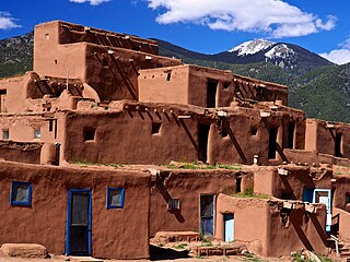
WTaos Pueblo is an ancient pueblo belonging to a Taos-speaking (Tiwa) Native American tribe of Puebloan people. It lies about 1 mile (1.6 km) north of the modern city of Taos, New Mexico. The pueblos are considered to be one of the oldest continuously inhabited communities in the United States. This has been designated a UNESCO World Heritage Site.
 W
WToo-Cowee, was an important historic Cherokee town located near the Little Tennessee River north of present-day Franklin, North Carolina. It also had a prehistoric platform mound and earlier village built by ancestral peoples. As their expression of public architecture, the Cherokee built a townhouse on top of the mound. It was the place for their community gatherings in their highly decentralized society. The name translates to "pig fat" in English. British traders and colonists referred to Cowee as one of the Cherokee Middle Towns along this river; they defined geographic groupings based in relation to their coastal settlements, such as Charlestown, South Carolina.
 W
WThe Treaty of Shackamaxon, also called the Great Treaty and Penn's Treaty, was a legendary treaty between William Penn and Tamanend of the Lenape signed in 1682. Penn and Tamanend agreed that their people would live in a state of perpetual peace.
 W
WTugaloo was a Cherokee town located on the Tugaloo River, at the mouth of Toccoa Creek. It was south of Toccoa and Travelers Rest State Historic Site in present-day Stephens County, Georgia. Cultures of ancient indigenous peoples had occupied this area, and those of the South Appalachian Mississippian culture built a platform mound and village here. It was an administrative and ceremonial center for them.
 W
WThe Waddells Mill Pond Site is an archaeological site located seven miles northwest of Marianna, Florida. On December 15, 1972, it was added to the U.S. National Register of Historic Places.
 W
WWerowocomoco was a village that served as the headquarters of Chief Powhatan, a Virginia Algonquian political and spiritual leader when the English founded Jamestown in 1607. The name Werowocomoco comes from the Powhatan werowans (weroance), meaning "leader" in English; and komakah (-comoco), "settlement". The town was documented by English settlers in 1608 as located near the north bank of the York River in what is now Gloucester County. It was separated by that river and the narrow Virginia Peninsula from the English settlement of Jamestown, located on the James River.