 W
WOrienteering is a group of sports that require navigational skills using a map and compass to navigate from point to point in diverse and usually unfamiliar terrain whilst moving at speed. Participants are given a topographical map, usually a specially prepared orienteering map, which they use to find control points. Originally a training exercise in land navigation for military officers, orienteering has developed many variations. Among these, the oldest and the most popular is foot orienteering. For the purposes of this article, foot orienteering serves as a point of departure for discussion of all other variations, but almost any sport that involves racing against a clock and requires navigation with a map is a type of orienteering.
 W
WAmateur radio direction finding is an amateur racing sport that combines radio direction finding with the map and compass skills of orienteering. It is a timed race in which individual competitors use a topographic map, a magnetic compass and radio direction finding apparatus to navigate through diverse wooded terrain while searching for radio transmitters. The rules of the sport and international competitions are organized by the International Amateur Radio Union. The sport has been most popular in Eastern Europe, Russia, and China, where it was often used in the physical education programs in schools.
 W
WBiathlon orienteering or orienteering shooting is a multisport consisting of shooting and orienteering. The sport is organized internationally by the International Biathlon Orienteering Federation (IBOF), and is mainly practiced in the Nordic countries as well as a few other European countries. Competitions are organised in Denmark by Danish Military Sports Association (DMSA), in Sweden by the civilian Swedish Multisport Association and in Finland by the Finnish Reservist Sports Federation (FRSF).
 W
WCanoe orienteering (canoe-O) is an orienteering sport using a canoe, kayak, or other small boat. Usually, a canoe-O is a timed race in which one- or two-person boats start at staggered intervals, are timed, and are expected to perform all navigation on their own. Portages are allowed. The control points, shown on an orienteering map, may be visited in any order. Standings are determined first by successful completion of the course, then by shortest time on course.
 W
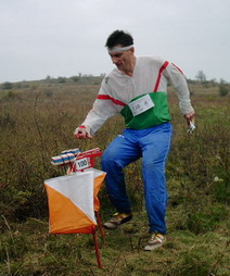
WA control point is a marked waypoint used in orienteering and related sports such as rogaining and adventure racing. It is located in the competition area; marked both on an orienteering map and in the terrain, and described on a control description sheet. The control point must be identifiable on the map and on the ground. A control point has three components: a high visibility item, known as a flag or kite; an identifier, known as a control code; and a recording mechanism for contestants to record proof that they visited the control point. The control point is usually temporary, except on a permanent orienteering course.
 W
WAn orienteering course is composed of a start point, a series of control points, and a finish point. Controls are marked with a white and orange flag in the terrain, and corresponding purple symbols on an orienteering map. The challenge is to complete the course by visiting all control points in the shortest possible time, aided only by the map and a compass.
 W
WEncirclement is a military term for the situation when a force or target is isolated and surrounded by enemy forces.
 W
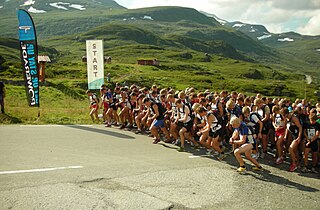
WFell running, also sometimes known as hill running, is the sport of running and racing, off-road, over upland country where the gradient climbed is a significant component of the difficulty. The name arises from the origins of the English sport on the fells of northern Britain, especially those in the Lake District. It has elements of trail running, cross country and mountain running, but is also distinct from those disciplines.
 W
WFoot orienteering is the oldest formal orienteering sport, and the one with the most "starts" per year. Usually, a FootO is a timed race in which participants start at staggered intervals, are individually timed, and are expected to perform all navigation on their own. The control points are shown on the orienteering map and must be visited in the specified order. Standings are determined first by successful completion of the course, then by shortest time on course.
 W
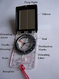
WA hand compass is a compact magnetic compass capable of one-hand use and fitted with a sighting device to record a precise bearing or azimuth to a given target or to determine a location. Hand or sighting compasses include instruments with simple notch-and-post alignment ("gunsights"), prismatic sights, direct or lensatic sights, and mirror/vee (reflected-image) sights. With the additional precision offered by the sighting arrangement, and depending upon construction, sighting compasses provide increased accuracy when measuring precise bearings to an objective.
 W
WThe Ice Age Trail is a National Scenic Trail stretching 1,200 miles (1,900 km) in the state of Wisconsin in the United States. The trail is administered by the National Park Service, and is constructed and maintained by private and public agencies including the Ice Age Trail Alliance, a non-profit and member-volunteer based organization with local chapters.
 W
WThe International Orienteering Federation (IOF) is the international governing body of the sport of orienteering. The IOF head office is located in Karlstad, Sweden.
 W
WInternational Rogaining Federation (IRF) is the peak international body for the sport of rogaining. The aims of the IRF are to promote rogaining worldwide, maintain the culture and the rules of the sport.
 W
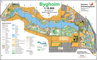
WAn orienteering map is a map specially prepared for use in orienteering competitions. It is a topographic map with extra details to help the competitor navigate through the competition area.
 W
WMountain bike orienteering is an orienteering endurance racing sport on a mountain bike where navigation is done along trails and tracks. Compared with foot orienteering, competitors usually are not permitted to leave the trail and track network. Navigation tactics are similar to ski-orienteering, where the major focus is route choice while navigating. The main difference compared to ski-orienteering is that navigation is done at a higher pace, because the bike can reach higher speeds. As the biker reaches higher speeds, map reading becomes more challenging.
 W
WThe North American Orienteering Championships (NAOC) is an biannual orienteering event organized by the International Orienteering Federation.
 W
WRandonautica is an app launched on February 22, 2020 founded by Joshua Lengfelder. It randomly generates coordinates that enable the user to explore their local area and report on their findings. According to its creators, the app is "an attractor of strange things," letting one choose specific coordinates based on a certain theme. It has gained controversy after several reports on the app generating coordinates, seemingly coincidentally, where disturbing things were present.
 W
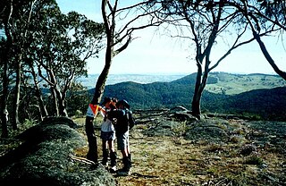
WRogaining is an orienteering sport of long distance cross-country navigation, involving both route planning and navigation between checkpoints using a variety of map types. In a rogaine, teams of two to five people choose which checkpoints to visit within a time limit with the intent of maximizing their score. Teamwork, endurance, competition and an appreciation for the natural environment are features of the sport. Championship rogaines are 24 hours long, but rogaines can be as short as two hours.
 W
WA salient, also known as a bulge, is a battlefield feature that projects into enemy territory. The salient is surrounded by the enemy on multiple sides, making the troops occupying the salient vulnerable. The opponent's front line that borders a salient is referred to as a re-entrant – that is, an angle pointing inwards. A deep salient is vulnerable to being "pinched out" through the base, and this will result in a pocket in which the forces in the salient become isolated and without a supply line. On the other hand, a breakout of the forces within the salient through its tip can threaten the rear areas of the opposing forces outside it, leaving them open to an attack from behind.
 W
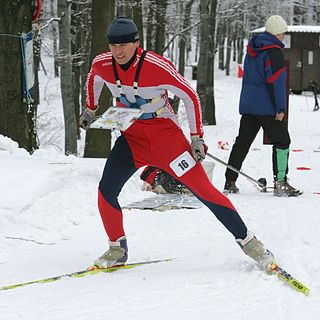
WSki orienteering (SkiO) is a cross-country skiing endurance winter racing sport and one of the four orienteering disciplines recognized by the IOF. A successful ski orienteer combines high physical endurance, strength and excellent technical skiing skills with the ability to navigate and make the best route choices while skiing at a high speed.
 W
WA thumb compass is a type of compass commonly used in orienteering, a sport in which map reading and terrain association are paramount. In cases of homogeneous terrain with few distinct features, a bearing between 2 known points on the map may be used. Consequently, most thumb compasses have minimal or no degree markings at all, and are normally used only to take bearings directly from a map, and to orient a map to magnetic north. Thumb compasses are also often transparent so that an orienteer can hold a map in the hand with the compass and see the map through the compass.
 W
WTrail orienteering (TrailO) is an orienteering sport that involves precise reading of an orienteering map and the corresponding terrain. Trail orienteers must identify, in the terrain and in the presence of decoys, control points shown on the map. TrailO involves navigation skills but unlike most other forms of orienteering, it involves no point to point racing and little or no route choice. It is conducted usually on trails and because the objective is accuracy, not the speed of physical movement, the sport is accessible to physically disabled competitors on equal terms as able-bodied.
 W
WOrienteering is a group of sports that require navigational skills using a map and compass to navigate from point to point in diverse and usually unfamiliar terrain whilst moving at speed. Participants are given a topographical map, usually a specially prepared orienteering map, which they use to find control points. Originally a training exercise in land navigation for military officers, orienteering has developed many variations. Among these, the oldest and the most popular is foot orienteering. For the purposes of this article, foot orienteering serves as a point of departure for discussion of all other variations, but almost any sport that involves racing against a clock and requires navigation with a map is a type of orienteering.
 W
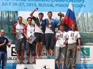
WThe World Rogaining Championships are the championships of the International Rogaining Federation (IRF) and the pinnacle rogaining event in the world. The championships are organised by the national rogaining organisation chosen by the IRF as the host of that particular championships.