 W
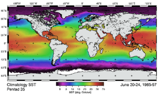
WThe Advanced Very-High-Resolution Radiometer (AVHRR) instrument is a space-borne sensor that measure the reflectance of the Earth in five spectral bands that are relatively wide by today's standards. AVHRR instruments are or have been carried by the National Oceanic and Atmospheric Administration (NOAA) family of polar orbiting platforms (POES) and European MetOp satellites. The instrument scans several channels; two are centered on the red (0.6 micrometres) and near-infrared (0.9 micrometres) regions, a third one is located around 3.5 micrometres, and another two the thermal radiation emitted by the planet, around 11 and 12 micrometres.
 W
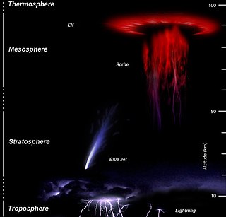
WAtmosphere-Space Interactions Monitor (ASIM) is a project led by the European Space Agency to place cameras and X-ray/γ-ray detectors on the International Space Station to observe the upper atmosphere in order to study sprites, jets and elves and terrestrial gamma-ray flashes in connection with thunderstorms. It is hoped that measurements of these phenomena from space will contribute to the understanding of Earth's upper atmosphere.
 W
WOver the last two centuries many environmental chemical observations have been made from a variety of ground-based, airborne, and orbital platforms and deposited in databases. Many of these databases are publicly available. All of the instruments mentioned in this article give online public access to their data. These observations are critical in developing our understanding of the Earth's atmosphere and issues such as climate change, ozone depletion and air quality. Some of the external links provide repositories of many of these datasets in one place. For example, the Cambridge Atmospheric Chemical Database, is a large database in a uniform ASCII format. Each observation is augmented with the meteorological conditions such as the temperature, potential temperature, geopotential height, and equivalent PV latitude.
 W
WCALIPSO is a joint NASA (USA) and CNES (France) environmental satellite, built in the Cannes Mandelieu Space Center, which was launched atop a Delta II rocket on April 28, 2006. Its name stands for Cloud-Aerosol Lidar and Infrared Pathfinder Satellite Observations.
 W
WCloud albedo is a measure of the albedo of a cloud. Higher values indicate that a cloud reflects a larger amount of solar radiation and transmits a smaller amount of radiation. Cloud albedo depends on the total mass of water, the size and shape of the droplets or particles and their distribution in space.
 W
WThe coastal zone color scanner (CZCS) was a multi-channel scanning radiometer aboard the Nimbus 7 satellite, predominately designed for water remote sensing. Nimbus 7 was launched 24 October 1978, and CZCS became operational on 2 November 1978. It was only designed to operate for one year, but in fact remained in service until 22 June 1986. Its operation on board the Nimbus 7 was limited to alternate days as it shared its power with the passive microwave scanning multichannel microwave radiometer.
 W
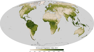
WThe enhanced vegetation index (EVI) is an 'optimized' vegetation index designed to enhance the vegetation signal with improved sensitivity in high biomass regions and improved vegetation monitoring through a de-coupling of the canopy background signal and a reduction in atmosphere influences. EVI is computed following this equation:
The Environmental Science Services Administration (ESSA) was a United States Federal executive agency created in 1965 as part of a reorganization of the United States Department of Commerce. Its mission was to unify and oversee the meteorological, climatological, hydrographic, and geodetic operations of the United States. It operated until 1970, when it was replaced by the new National Oceanic and Atmospheric Administration (NOAA).
 W
WThe European Organisation for the Exploitation of Meteorological Satellites (EUMETSAT) is an intergovernmental organisation created through an international convention agreed by a current total of 30 European Member States.
 W
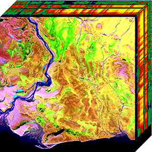
WHyperspectral imaging, like other spectral imaging, collects and processes information from across the electromagnetic spectrum. The goal of hyperspectral imaging is to obtain the spectrum for each pixel in the image of a scene, with the purpose of finding objects, identifying materials, or detecting processes. There are three general branches of spectral imagers. There are push broom scanners and the related whisk broom scanners, which read images over time, band sequential scanners, which acquire images of an area at different wavelengths, and snapshot hyperspectral imaging, which uses a staring array to generate an image in an instant.
 W
WThe infrared atmospheric window refers to a region of the Infrared spectrum where there is relatively little absorption of terrestrial thermal radiation by atmospheric gases. The window plays an important role in the atmospheric greenhouse effect by maintaining the balance between incoming solar radiation and outgoing IR to space. In the earth's atmosphere this window is roughly the region between 8 and 14 μm although it can be narrowed or closed at times and places of high humidity because of the strong absorption in the water vapor continuum or because of blocking by clouds. It covers a substantial part of the spectrum from surface thermal emission which starts at roughly 5 μm. Principally it is a large gap in the absorption spectrum of water vapor. Carbon dioxide plays an important role in setting the boundary at the long wavelength end. Ozone partly blocks transmission in the middle of the window.
 W
WISS-RapidScat was an instrument mounted to the International Space Station's Columbus module that measured wind speeds. It was launched aboard SpaceX CRS-4 in September 2014 and operated until August 2016. ISS-RapidScat was a scatterometer designed to support weather forecasting by bouncing microwaves off the ocean's surface to measure wind speed. It featured a 75 cm (30 in) rotating radar dish that operated at 13.4 GHz. It could collect data between 51.6 degrees north and south latitude, with a swath 900 km wide (560 mi).
 W
WMobile mapping is the process of collecting geospatial data from a mobile vehicle, typically fitted with a range of GNSS, photographic, radar, laser, LiDAR or any number of remote sensing systems. Such systems are composed of an integrated array of time synchronised navigation sensors and imaging sensors mounted on a mobile platform. The primary output from such systems include GIS data, digital maps, and georeferenced images and video.
 W
WThe Mohammed Bin Rashid Space Centre, is a Dubai government organisation working on the UAE space programme, which includes various space satellite projects, the Emirates Mars Mission, and the UAE astronaut programme. The centre actively works to promote space science and research in the region. The centre encompasses the Emirates Institution for Advanced Science and Technology (EIAST).
 W
WMicrowave Sounding Unit temperature measurements refers to temperature measurement using the Microwave Sounding Unit instrument and is one of several methods of measuring Earth atmospheric temperature from satellites. Microwave measurements have been obtained from the troposphere since 1979, when they were included within NOAA weather satellites, starting with TIROS-N. By comparison, the usable balloon (radiosonde) record begins in 1958 but has less geographic coverage and is less uniform.
 W
WThe normalized difference vegetation index (NDVI) is a simple graphical indicator that can be used to analyze remote sensing measurements, often from a space platform, assessing whether or not the target being observed contains live green vegetation.
 W
WThe Orbiting Carbon Observatory-3 (OCO-3) is a NASA-JPL instrument designed to measure carbon dioxide in Earth's atmosphere. The instrument is mounted on the Japanese Experiment Module-Exposed Facility on board the International Space Station (ISS). OCO-3 was scheduled to be transported to space by a SpaceX Dragon from a Falcon 9 rocket on 30 April 2019, but the launch was delayed to 3 May, due to problems with the space station's electrical power system. This launch was further delayed to 4 May due to electrical issues aboard Of Course I Still Love You (OCISLY), the barge used to recover the Falcon 9’s first stage. OCO-3 was launched as part of CRS-17 on 4 May 2019 at 06:48 UTC. The nominal mission lifetime is three years.
 W
WPicoSAT, launched on September 30, 2001, is a real time tracking satellite. The name "PICO" combines the first letters of all four of its experiments. PICOSat series are designed for a minimum of one year of on-orbit operations.
 W
WRadio occultation (RO) is a remote sensing technique used for measuring the physical properties of a planetary atmosphere or ring system.
 W
WSAGE III on ISS is the fourth generation of a series of NASA Earth-observing instruments, known as the Stratospheric Aerosol and Gas Experiment. The first SAGE III instrument was launched on the Russian Meteor (satellite) spacecraft. The recently revised SAGE III will be mounted to the International Space Station where it will use the unique vantage point of ISS to make long-term measurements of ozone, aerosols, water vapor, and other gases in Earth's atmosphere.
 W
WSatellite temperature measurements are inferences of the temperature of the atmosphere at various altitudes as well as sea and land surface temperatures obtained from radiometric measurements by satellites. These measurements can be used to locate weather fronts, monitor the El Niño-Southern Oscillation, determine the strength of tropical cyclones, study urban heat islands and monitor the global climate. Wildfires, volcanos, and industrial hot spots can also be found via thermal imaging from weather satellites.
 W
WThe Shuttle Radar Topography Mission (SRTM) is an international research effort that obtained digital elevation models on a near-global scale from 56°S to 60°N, to generate the most complete high-resolution digital topographic database of Earth prior to the release of the ASTER GDEM in 2009. SRTM consisted of a specially modified radar system that flew on board the Space Shuttle Endeavour during the 11-day STS-99 mission in February 2000. The radar system was based on the older Spaceborne Imaging Radar-C/X-band Synthetic Aperture Radar (SIR-C/X-SAR), previously used on the Shuttle in 1994. To acquire topographic data, the SRTM payload was outfitted with two radar antennas. One antenna was located in the Shuttle's payload bay, the other – a critical change from the SIR-C/X-SAR, allowing single-pass interferometry – on the end of a 60-meter (200-foot) mast that extended from the payload bay once the Shuttle was in space. The technique employed is known as interferometric synthetic aperture radar. Intermap Technologies was the prime contractor for processing the interferometric synthetic aperture radar data.
 W
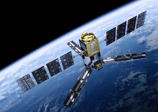
WSoil Moisture and Ocean Salinity (SMOS) is a satellite which forms part of ESA's Living Planet Programme. It is intended to provide new insights into Earth's water cycle and climate. In addition, it is intended to provide improved weather forecasting and monitoring of snow and ice accumulation.
 W
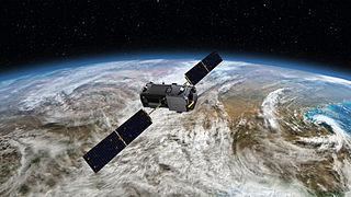
WSpace-based measurements of carbon dioxide are used to help answer questions about Earth's carbon cycle. There are a variety of active and planned instruments for measuring carbon dioxide in Earth's atmosphere from space. The first satellite mission designed to measure CO2 was the Interferometric Monitor for Greenhouse Gases (IMG) on board the ADEOS I satellite in 1996. This mission lasted less than a year. Since then, additional space-based measurements have begun, including those from two high-precision satellites. Different instrument designs may reflect different primary missions.
 W
WThe Spaceborne Imaging Radar (SIR) – full name 'Spaceborne Imaging Radar-C/X-band Synthetic Aperture Radar (SIR-C/X-SAR)', is a synthetic aperture radar which flew on two separate shuttle missions. Once from the Space Shuttle Endeavour in April 1994 on (STS-59) and again in October 1994 on (STS-68). The radar was run by NASA's Space Radar Laboratory. SIR utilizes 3 radar frequencies: L band, C band (6 cm) and X band (3 cm), allowing for study of geology, hydrology, ecology and oceanography. Comparing radar images to data collected by teams of people on the ground as well as aircraft and ships using simultaneous measurements of vegetation, soil moisture, sea state, snow and weather conditions during each flight. The imaging radar was able to take images anytime regardless of clouds cover. The Radar-C system was built and operated by NASA's Jet Propulsion Laboratory (JPL). The mission was a joint work of NASA with the German and Italian space agencies. Each of the week long mission scanned about 50 million square kilometers of the Earth's surface,.
 W
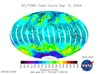
WThe Total Ozone Mapping Spectrometer (TOMS) was a NASA satellite instrument, specifically a spectrometer, for measuring the ozone layer. Of the five TOMS instruments which were built, four entered successful orbit. The satellites carrying TOMS instruments were:Nimbus 7; launched October 24, 1978. Operated until 1 August 1994. Carried TOMS instrument number 1. Meteor-3-5; launched 15 August 1991. Operated until December 1994. Was the first and last Soviet satellite to carry a USA made instrument. Carried TOMS instrument number 2. ADEOS I; launched 17 August 1996. Operated until 30 June 1997. Mission was cut short by a spacecraft failure. TOMS-Earth Probe; launched on July 2, 1996. Operated until 2 December 2006. Carried TOMS instrument number 3. QuikTOMS; launched 21 September 2001. Suffered launch failure and did not enter orbit.
 W
WTropospheric Emissions: Monitoring of Pollution (TEMPO) is a NASA Earth Venture-Instrument that will measure North American pollution at a high resolution and on an hourly basis. It is an ultraviolet–visible spectrometer maintaining a constant view of North America, enabling it to provide daily data on ozone, nitrogen dioxide, and other elements in the atmosphere.
 W
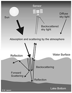
WWater Remote Sensing studies the color of water through the observation of the spectrum of water leaving radiation. From the study of this spectrum, the concentration of optically active components of the upper layer of the water body can be concluded via specific algorithms. Water quality monitoring by remote sensing and close-range instruments has obtained considerable attention since the founding of EU Water Framework Directive.