 W
WThe Albanian tribes form a historical mode of social organization (farefisní) in Albania and the southwestern Balkans characterized by a common culture, often common patrilineal kinship ties tracing back to one progenitor and shared social ties. The fis stands at the center of Albanian organization based on kinship relations, a concept which can be found among southern Albanians also with the term farë.
 W
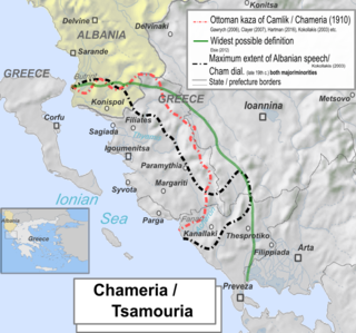
WChameria is a term used today mostly by Albanians for parts of the coastal region of Epirus in southern Albania and the historical Greek region of Epirus, traditionally associated with an Albanian speaking population called Chams. For a brief period (1909-1912), three kazas were combined by the Ottomans into an administrative district called Çamlak sancak. Apart from geographical usages, in contemporary times within Albania the toponym has also acquired irredentist connotations. During the interwar period, the toponym was in common use and the official name of the area above the Acheron river in all Greek state documents. Today it is obsolete in Greek, surviving in some old folk songs. Most of what is called Chameria is divided between parts of the Greek regional units of Thesprotia, Preveza, and Ioannina ; and the municipality of Konispol at the southernmost extremity of Albania. As the wider Greek toponyms Epirus has existed since antiquity and the narrower Thesprotia also reflects an ancient name, and given the negative sentiments towards Albanian irredentism, the term is not used by the locals on the Greek side of the border.
 W
WDevoll is a municipality in Korçë County, southeastern Albania. It was created in 2015 by the merger of the former municipalities Bilisht, Hoçisht, Miras, Progër and Qendër Bilisht. The seat of the municipality is the town of Bilisht. The total population is 26,716, in a total area of 458 km2 (177 sq mi). It derives its name from the Devoll river flowing through the valley. The busy border point Kapshticë/Krystallopigi connects Devoll with the Greek regional units of Florina and Kastoria to the east and southeast. Devoll borders the municipalities of Kolonjë to the southwest, Korçë to the west, Maliq to the northwest and Pustec to the north.
 W
WThe Dibër valley is a section of the Drin valley in the border region between North Macedonia and Albania.
 W
WDrenica, also known as the Drenica Valley, is a hilly region in central Kosovo, covering roughly around 700 square kilometres (270 sq mi) of Kosovo's total area (6%). It consists of two municipalities, Glogovac and Skenderaj, and several villages in Klina, Kërligatë village in Zubin Potok, Mitrovica and the area of Vučitrn. It is located west of the capital, Pristina.
 W
WDropull is a municipality and a predominantly Greek-inhabited region in Gjirokastër County, in southern Albania. The region stretches from south of the city of Gjirokastër to the Greek–Albanian border, along the Drino river. The region's villages are part of the Greek "minority zone" recognized by the Albanian government, in which live majorities of ethnic Greeks.
 W
WDukagjin highlands is a mountainous region in northern Albania, east of Shkodra and north of the Drin. It is roughly equivalent to the northern half of the Shkodër District, with some minor parts in Malësi e Madhe District.
 W
WThe Ghegs are one of two major dialectal subgroups of Albanians They are also differentiated by minor cultural, social and religious characteristics. The Ghegs live in Albania, Kosovo, North Macedonia, Serbia and Montenegro. The Ghegs speak Gheg Albanian, one of the two main dialects of Albanian language. The social organization of the Ghegs was traditionally tribal, with several distinct tribal groups of Ghegs.
 W
WGollobordë refers to a geographical area of traditionally 24 villages of which 18 are situated primarily in eastern Albania, with a small portion consisting of six villages lying within North Macedonia. This region is located within the Dibër and Elbasan counties which contain both Macedonian and Albanian villages.
 W
WGora is a geographical region in southern Kosovo and northeastern Albania, primarily inhabited by the Gorani people. Due to geopolitical circumstances, some of the local Gorani people have over time also self declared themselves as Albanians, Macedonians, Bosniaks, Muslim Bulgarians, Serbs, Turks and Muslims (nationality).
 W
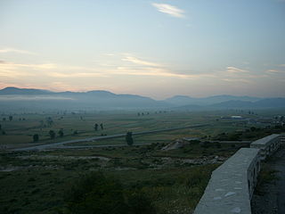
WHas is a region in north eastern Albania and south western Kosovo.
 W
WHimara or Himarë is a bilingual region and municipality in southern Albania, part of Vlorë County. It lies between the Ceraunian Mountains and the Ionian Sea and is part of the Albanian Riviera. The region consists of the town of Himarë and the villages of Dhërmi, Pilur, Kudhës, Qeparo, Vuno, Ilias, and Palasë. The municipality was formed at the 2015 local government reform by the merger of the former municipalities Himarë, Horë-Vranisht and Lukovë, that became municipal units. The total population is 7,818, in a total area of 572.22 km2 (220.94 sq mi). The population of the former municipality at the 2011 census was 2,822.
 W
WKolonjë is a municipality in Korçë County, southeastern Albania. It was created in 2015 by the merger of the former municipalities Barmash, Çlirim, Ersekë, Leskovik, Mollas, Novoselë, Qendër Ersekë and Qendër Leskovik. The seat of the municipality is the town Ersekë. The total population is 11,070, in a total area of 865 km2 (334 sq mi). It is an ethnographic region.
 W
WKrasniqi is a historical Albanian tribe and region in the Accursed Mountains in northeastern Albania, bordering Kosovo. The region lies within the Tropojë District and is part of a wider area between Albania and Kosovo that is historically known as Malësia e Gjakovës. Krasniqi stretches from the Valbonë river in the north to Lake Fierza in the south and includes the town Bajram Curri. Members of the Krasniqi tribe are also found in Kosovo and Northern Macedonia.
 W
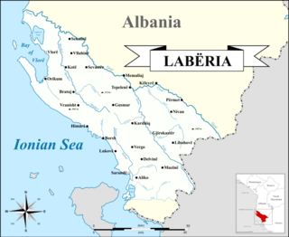
WLabëria is a historic region that is roughly situated in southwestern Albania. Its inhabitants are known as Labs and its boundaries reach from Vlorë to Himara in the south, to the Greek border near Sarandë, incorporating the Kurvelesh region of Gjirokastër District and extending east to the city of Tepelenë.
 W
WLibrazhd District was one of the 36 districts of Albania, which were dissolved in July 2000 and replaced by 12 newly created counties. It had a population of 72,520 in 2001, and an area of 1,102 km2 (425 sq mi). It was formed as an administrative unit in 1958. It is in the east of the country, and its capital and administrative center was the town of Librazhd. The area of the former district includes most of the regions of the ethnographic region. Its territory is now part of Elbasan County: the municipalities of Librazhd and Prrenjas.
 W
WLumë is a region that extends itself in northeastern Albania and southwest Kosovo whose territory is synonymous
 W
WMala Prespa is a term used to denote a geographical area in eastern Albania, part of the wider region of Prespa. It is located on the western shore of Lake Prespa along the southeastern edge of Albania within the wider Korçë County and bordering the Pogradec and Devoll municipalities. The area is synonymous with Pustec Municipality.
 W
WMalësia e Madhe, known simply as Malësia or Malsia, is a historical and ethnographic region in northern Albania and eastern central Montenegro corresponding to the highlands of the geographical subdivision of the Malësi e Madhe District in Albania and Tuzi Municipality in Montenegro. The largest settlement in the area is the town of Tuzi.
 W
WMaliq-Opar is a community in the Korçë County, Albania. At the 2015 local government reform it became part of the municipality Maliq.
 W
WMallakastër is a region and a municipality in Fier County, southwestern Albania. It was created in 2015 by the merger of the present municipalities Aranitas, Ballsh, Fratar, Greshicë, Hekal, Kutë, Ngraçan, Qendër Dukas and Selitë. The seat of the municipality is the town Ballsh. The total population is 27,062, in a total area of 329.37 km2. It is coterminous with the former Mallakastër District.
 W
WMirdita is a region of northern Albania whose territory is synonymous with the historic Albanian tribe of the same name.
 W
WMirditë District was one of the 36 districts of Albania, which were dissolved in July 2000 and replaced by 12 newly created counties. It had a population of 37,055 in 2001, and an area of 867 km2 (335 sq mi). It is in the north of the country, and its capital was the town of Rrëshen. The district was located within the wider region of Mirdita, whose territory is synonymous with the historic Albanian tribe of the same name. The area of the former district is coextensive with the present municipality of Mirditë, which is part of Lezhë County.
 W
WNikaj-Mërtur is a region of Northern Albania whose territory is synonymous with the historic Albanian tribes of Mërturi and Nikaj. The region of Nikaj-Mërtur is located in the south-east of the Albanian Alps, bordering Dukagjin highlands within Tropojë District. It is a southern extension of the Gjakova highland. Nikaj shares the same patrilineal descent with most brotherhoods of Krasniqi tribe, while Mërturi is direct blood and relative to the Berisha, which is why it also called Berisha-Mërturi. In 2014, the region was proclaimed as the Nikaj-Mertur Regional Nature Park.
 W
WPogon, is a former commune in the Gjirokastër County, southern Albania. At the 2015 local government reform it became a subdivision of the municipality Dropull. The population at the 2011 census was 432. It consists of seven villages which are mostly Greek speaking: Poliçan; Skore; Hllomo; Sopik; Mavrojer; Çatistë and Selckë of which Poliçan is the administrative center. The administrative unit of Pogon is inhabited by ethnic Greeks, except for the village of Selckë.
 W
WRugova is a mountain region located to the north-west of the city of Peja, in Kosovo region. According to notes of Rugova it has been inhabited since before the 12th century. In 2013, it was designated a national park by the Parliament of Kosovo.
 W
WSkadarska Krajina, simply known as Krajina is a geographical region in southeastern Montenegro stretching from the southern coast of Lake Skadar to the mountain of Rumija, comprising several villages. It is inhabited mainly by Albanians and Montenegrins. The area is divided between the municipalities of Bar and Ulcinj.
 W
WSkrapar is a municipality in Berat County, southern Albania. It was created in 2015 by the merger of the former municipalities Bogovë, Çepan, Çorovodë, Gjerbës, Leshnjë, Potom, Qendër Skrapar, Vendreshë and Zhepë. The seat of the municipality is the town Çorovodë. The total population is 12,403, in a total area of 832.04 km2. It covers part of the area of the former Skrapar District, without the town Poliçan.
 W
WThe Tosks are one of two major dialectal subgroups of Albanians differentiated by their cultural, linguistic, social and religious characteristics.
 W
WTropojë District was one of the 36 districts of Albania, which were dissolved in July 2000 and replaced by 12 newly created counties. It had a population of 28,154 in 2001, and an area of 1,043 km2 (403 sq mi). It was in the north of the country, and its capital was the town of Bajram Curri. The area of the former district is coextensive with the present municipality of Tropojë, which is part of Kukës County. The area is known for its massive chestnuts forests and the river Valbonë, as well a rich folk culture.
 W
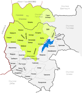
WUpper Reka is a geographic and ethnographic subregion of the broader Reka region of western Republic of North Macedonia, including settlements within the upper left portion of the Municipality of Mavrovo and Rostuša and of Gostivar Municipality. The region is home to both a Muslim Albanian community and Christian Orthodox Albanian speaking population that self identifies as Macedonians, though with some notable exceptions in past and recent times.
 W
WZadrima is a region in the district of Shkodër and Lezhë, Albania. It is mostly located in the Zadrima Plain. The region was part of the Principality of Dukagjini in the 15th century.
 W
WZagoria (Aromanian: Zaguria, Zagurii) is a former municipality in the Gjirokastër County, southern Albania. During the 2015 local government reform, Zagoria became a subdivision of the municipality Libohovë. The population at the 2011 census was 411. Since 2018, the region is at the centre of the expanded Zagoria Nature Park. Zagoria is also considered to be a distinct "ethnographic region", traditionally consisting of 10 settlements: Sheper, Nivan, Ndëran, Topovë, Konckë, Hoshteve, Lliar, Vithuq, Doshnicë and Zhej.