 W
WSoil is a mixture of organic matter, minerals, gases, liquids, and organisms that together support life. Earth's body of soil, called the pedosphere, has four important functions:as a medium for plant growth as a means of water storage, supply and purification as a modifier of Earth's atmosphere as a habitat for organisms
 W
WIn environments containing permafrost, the active layer is the top layer of soil that thaws during the summer and freezes again during the autumn. In all climates, whether they contain permafrost or not, the temperature in the lower levels of the soil will remain more stable than that at the surface, where the influence of the ambient temperature is greatest. This means that, over many years, the influence of cooling in winter and heating in summer will decrease as depth increases.
 W
WAnthroposols are soils which have been profoundly modified or constructed by humans. They typically have one or more of their natural soil horizons modified, removed or replaced. The word anthroposol is derived from the Greek words anthropos, meaning man and genes meaning caused. Anthroposols are typically found on industrial, commercial, urban and resources extraction sites as well as throughout transportation, fuel and power corridors.
 W
WBase-cation saturation ratio (BCSR) is a method of interpreting soil test results that is widely used in sustainable agriculture, supported by the National Sustainable Agriculture Information Service (ATTRA) and claimed to be successfully in use on over a million acres (4,000 km²) of farmland worldwide. The traditional method, as used by most university laboratories, is known variously as the 'sufficiency level', sufficiency level of available nutrients (SLAN), or Index(UK) system. The sufficiency level system is concerned only with keeping plant-available nutrient levels within a well studied range, making sure there is neither a deficiency nor an excess. In the BCSR system, soil cations are balanced according to varying ratios often stated as giving 'ideal' or 'balanced' soil. These ratios can be between individual cations, such as the calcium to magnesium ratio, or they may be expressed as a percentage saturation of the cation exchange capacity (CEC) of the soil. Most 'ideal soil' theories stress both approaches.
 W
WBaseball rubbing mud is mud used to treat balls in the sport of baseball to give pitchers better control and a firmer grip on the balls.
 W
WBokashi is a process that converts food waste and similar organic matter into a soil amendment which adds nutrients and improves soil texture. It differs from traditional composting methods in several respects. The most important are:The input matter is fermented by specialist bacteria, not decomposed. The fermented matter is fed directly to field or garden soil, without requiring further time to mature. As a result, virtually all input carbon, energy and nutrients enter the soil food web, having been neither emitted in greenhouse gases and heat nor leached out.
 W
WBujeo is a type of soil found on the countryside of Andalusia, mainly the area of the Guadalquivir valley.
 W
WCalcareous grassland is an ecosystem associated with thin basic soil, such as that on chalk and limestone downland. Plants on calcareous grassland are typically short and hardy, and include grasses and herbs such as clover. Calcareous grassland is an important habitat for insects, particularly butterflies, and is kept at a plagioclimax by grazing animals, usually sheep and sometimes cattle. Rabbits used to play a part but due to the onset of myxomatosis their numbers decreased so dramatically that they no longer have much of a grazing effect.
 W
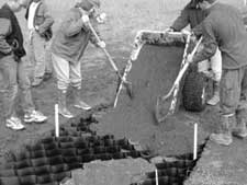
WCellular confinement systems (CCS)—also known as geocells—are widely used in construction for erosion control, soil stabilization on flat ground and steep slopes, channel protection, and structural reinforcement for load support and earth retention. Typical cellular confinement systems are geosynthetics made with ultrasonically welded high-density polyethylene (HDPE) strips or novel polymeric alloy (NPA)—and expanded on-site to form a honeycomb-like structure—and filled with sand, soil, rock, gravel or concrete.
 W
WClimate change mitigation consists of actions to limit global warming and its related effects. This involves reductions in human emissions of greenhouse gases (GHGs) as well as activities that reduce their concentrations in the atmosphere.
 W
WCompost is made by decomposing organic materials into simpler organic and inorganic compounds in a process called composting. This process recycles various organic materials otherwise regarded as waste products. A good compost is rich in plant nutrients and beneficial organisms.
 W
WContour trenching is an agricultural technique that can be easily applied in arid sub-Sahara areas to allow for water, and soil conservation, and to increase agricultural production.
 W
WDark earth in archaeology is an archaeological horizon, as much as 1 metre (3 ft) thick, indicating settlement over long periods of time. The material is high in organic matter, including charcoal, which gives it its characteristic dark colour; it may also contain fragments of pottery, tile, animal bone and other artefacts. It is interpreted as soil enriched with the sooty remains of thatched roofs from houses without chimneys, with other waste materials. In some areas it appears to give the soil added fertility.
 W
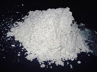
WDiatomaceous earth, diatomite or kieselgur/kieselguhr is a naturally occurring, soft, siliceous sedimentary rock that has been crumbled into a fine white to off-white powder. It has a particle size ranging from less than 3 μm to more than 1 mm, but typically 10 to 200 μm. Depending on the granularity, this powder can have an abrasive feel, similar to pumice powder, and has a low density as a result of its high porosity. The typical chemical composition of oven-dried diatomaceous earth is 80–90% silica, with 2–4% alumina and 0.5–2% iron oxide.
 W
WDirt! The Movie is a 2009 American documentary film directed by filmmakers Gene Rosow and Bill Benenson and narrated by Jamie Lee Curtis. It was inspired by the book Dirt: The Ecstatic Skin of the Earth by William Bryant Logan. The documentary starred environmentalists like Wangari Maathai, Vandana Shiva, Gary Vaynerchuk, Paul Stamets and Bill Logan. The film explores the relationship between humans and soil, including its necessity for human life and impacts by society.
 W
WA drainage equation is an equation describing the relation between depth and spacing of parallel subsurface drains, depth of the watertable, depth and hydraulic conductivity of the soils. It is used in drainage design.
 W
WDuricrust is a hard layer on or near the surface of soil. Duricrusts can range in thickness from a few millimeters or centimeters to several meters.
 W
WAn earth structure is a building or other structure made largely from soil. Since soil is a widely available material, it has been used in construction since prehistoric times. It may be combined with other materials, compressed and/or baked to add strength. Soil is still an economical material for many applications, and may have low environmental impact both during and after construction.
 W
WA fen is one of the main types of wetlands, the others being grassy marshes, forested swamps, and peaty bogs. Along with bogs, fens are a kind of mire. Fens are minerotrophic peatlands, usually fed by mineral-rich surface water or groundwater. They are characterized by their distinct water chemistry, which is pH neutral or alkaline, with relatively high dissolved mineral levels but few other plant nutrients. Continuous input of groundwater into fens maintains a stable water table throughout the course of a year. The stable water table helps maintain multiple defining characteristics of fens, namely the neutral pH, high base saturation, and low nutrient availability. They are usually dominated by grasses and sedges, and typically have brown mosses. Fens frequently have a high diversity of other plant species including carnivorous plants such as Pinguicula. They may also occur along large lakes and rivers where seasonal changes in water level maintain wet soils with few woody plants. The distribution of individual species of fen plants is often closely connected to water regimes and nutrient concentrations.
 W
WThe following is a list of plant species to be found in a north European fen habitat with some attempt to distinguish between reed bed relicts and the carr pioneers. However, nature does not come in neat compartments so that for example, the odd stalk of common reed will be found in carr.
 W
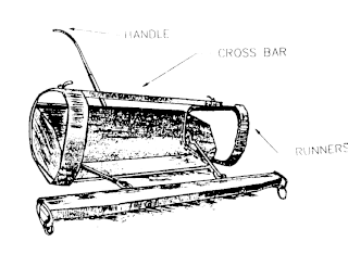
WThe Fresno Scraper is a machine pulled by horses used for constructing canals and ditches in sandy soil. The design of the Fresno Scraper forms the basis of most modern earthmoving scrapers, having the ability to scrape and move a quantity of soil, and also to discharge it at a controlled depth, thus quadrupling the volume which could be handled manually.
 W
WGeosmin is an irregular sesquiterpene, produced from the universal sesquiterpene precursor farnesyl pyrophosphate (also known as farnesyl diphosphate), in a two-step Mg2+-dependent reaction. Geosmin, along with the irregular monoterpene 2-methylisoborneol, together account for the majority of biologically-caused taste and odor outbreaks in drinking water worldwide. Geosmin has a distinct earthy or musty odor, which most people can easily smell. The odor detection threshold of geosmin is very low, ranging from 0.006 to 0.01 micrograms per liter in water. Geosmin is also responsible for the earthy taste of beetroots and a contributor to the strong scent (petrichor) that occurs in the air when rain falls after a dry spell of weather or when soil is disturbed.
 W
WImogolite is an aluminium silicate clay mineral with the chemical formula Al2SiO3(OH)4. It occurs in soils formed from volcanic ash and was first described in 1962 for an occurrence in Uemura, Kumamoto prefecture, Kyushu Region, Japan. Its name originates from the Japanese word imogo, which refers to the brownish yellow soil derived from volcanic ash. It occurs together with allophane, quartz, cristobalite, gibbsite, vermiculite and limonite.
 W
WAn inland salt marsh is a saltwater marsh located away from the coast which is formed and maintained in areas when evapotranspiration exceeds precipitation and/or when sodium- and chloride-laden groundwater is released from natural brine aquifers.
 W
WIn agriculture, leaching is the loss of water-soluble plant nutrients from the soil, due to rain and irrigation. Soil structure, crop planting, type and application rates of fertilizers, and other factors are taken into account to avoid excessive nutrient loss. Leaching may also refer to the practice of applying a small amount of excess irrigation where the water has a high salt content to avoid salts from building up in the soil. Where this is practiced, drainage must also usually be employed, to carry away the excess water.
 W
WLoam is soil composed mostly of sand, silt, and a smaller amount of clay. By weight, its mineral composition is about 40–40–20% concentration of sand–silt–clay, respectively. These proportions can vary to a degree, however, and result in different types of loam soils: sandy loam, silty loam, clay loam, sandy clay loam, silty clay loam, and loam.
 W
WLunar soil is the fine fraction of the regolith found on the surface of the Moon. Its properties can differ significantly from those of terrestrial dirt. The physical properties of lunar soil are primarily the result of mechanical disintegration of basaltic and anorthositic rock, caused by continual meteoric impacts and bombardment by solar and interstellar charged atomic particles over years. The process is largely one of mechanical weathering in which the particles are ground to finer and finer size over time. This situation contrasts fundamentally to terrestrial dirt formation, mediated by the presence of molecular oxygen (O2), humidity, atmospheric wind, and a robust array of contributing biological processes.
 W
WThere are six soil deposits in India. They are Alluvial soil, Black soil or regur, Red soil, Laterite soil, Desert or Arid soil, and Forest and mountainous soil. These soils are formed by the sediments brought down by the rivers. They are also rich in chemical ingredients.
 W
WMima mounds are low, flattened, circular to oval, domelike, natural mounds that are composed of loose, unstratified, often gravelly sediment that is an overthickened A horizon. These mounds range in diameter from 3 to more than 50 m; in height 30 cm to greater than 2 m; and in density from several to greater than 50 mounds per hectare, at times forming conspicuous natural patterns. Mima mounds can be seen at the Mima Mounds Natural Area Preserve in Washington state.
 W
WMud is soil, loam, silt or clay mixed with water. It usually forms after rainfall or near water sources. Ancient mud deposits harden over geological time to form sedimentary rock such as shale or mudstone. When geological deposits of mud are formed in estuaries, the resultant layers are termed bay muds.
 W
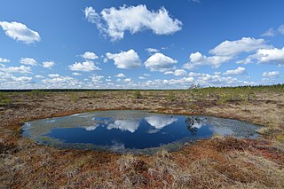
WPaludification is the most common process by which peatlands in the boreal zone are formed.
 W
WParticulate organic matter (POM) is a fraction of total organic matter operationally defined as that which does not pass through a filter pore size that typically ranges in size from 0.053 and 2 milimeters.
 W
WPeds are aggregates of soil particles formed as a result of pedogenic processes; this natural organization of particles forms discrete units separated by pores or voids. The term is generally used for macroscopic structural units when observing soils in the field. Soil peds should be described when the soil is dry or slightly moist, as they can be difficult to distinguish when wet.
 W
WPetrichor is the earthy scent produced when rain falls on dry soil. The word is constructed from Greek petra (πέτρα), "rock", or petros (πέτρος), "stone", and īchōr (ἰχώρ), the fluid that flows in the veins of the gods in Greek mythology.
 W
WPingos are intrapermafrost ice-cored hills, ranging in height from 3 to 70 m and 30 to 1,000 m in diameter. They are typically conical in shape and grow and persist only in permafrost environments, such as the Arctic and subarctic. A pingo is a periglacial landform, which is defined as a non-glacial landform or process linked to colder climates. It is estimated that there are more than 11,000 pingos on Earth. The Tuktoyaktuk peninsula area has the greatest concentration of pingos in the world with a total of 1,350 pingos. There are currently remarkably limited data on pingos.
 W
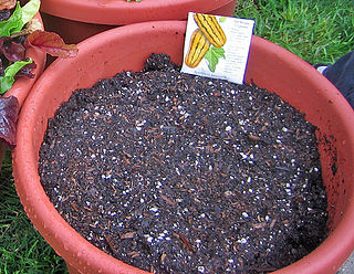
WPotting soil, also known as potting mix or miracle soil, is a medium in which to grow plants, herbs and vegetables in a pot or other durable container. The first recorded use of the term is from an 1861 issue of the American Agriculturist.
 W
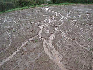
WIn hillslope geomorphology, a rill is a shallow channel cut into soil by the erosive action of flowing water. Similar but smaller incised channels are known as microrills; larger incised channels are known as gullies.
 W
WRock flour, or glacial flour, consists of fine-grained, silt-sized particles of rock, generated by mechanical grinding of bedrock by glacial erosion or by artificial grinding to a similar size. Because the material is very small, it becomes suspended in meltwater making the water appear cloudy, which is sometimes known as glacial milk.
 W
WA salt marsh or saltmarsh, also known as a coastal salt marsh or a tidal marsh, is a coastal ecosystem in the upper coastal intertidal zone between land and open saltwater or brackish water that is regularly flooded by the tides. It is dominated by dense stands of salt-tolerant plants such as herbs, grasses, or low shrubs. These plants are terrestrial in origin and are essential to the stability of the salt marsh in trapping and binding sediments. Salt marshes play a large role in the aquatic food web and the delivery of nutrients to coastal waters. They also support terrestrial animals and provide coastal protection.
 W
WA sandbag or dirtbag is a bag or sack made of hessian (burlap), polypropylene or other sturdy materials that is filled with sand or soil and used for such purposes as flood control, military fortification in trenches and bunkers, shielding glass windows in war zones, ballast, counterweight, and in other applications requiring mobile fortification, such as adding improvised additional protection to armoured vehicles or tanks.
 W
WSilcrete is an indurated soil duricrust formed when surface soil, sand, and gravel are cemented by dissolved silica. The formation of silcrete is similar to that of calcrete, formed by calcium carbonate, and ferricrete, formed by iron oxide. It is a hard and resistant material, and though different in origin and nature, appears similar to quartzite. As a duricrust, there is potential for preservation of root structures as trace fossils.
 W
WSilt is granular material of a size between sand and clay, whose mineral origin is quartz and feldspar. Silt may occur as a soil or as sediment mixed in suspension with water and soil in a body of water such as a river. It may also exist as soil deposited at the bottom of a water body, like mudflows from landslides. Silt has a moderate specific area with a typically non-sticky, plastic feel. Silt usually has a floury feel when dry, and a slippery feel when wet. Silt can be visually observed with a hand lens, exhibiting a sparkly appearance. It also can be felt by the tongue as granular when placed on the front teeth.
 W
WA slump is a form of mass wasting that occurs when a coherent mass of loosely consolidated materials or a rock layer moves a short distance down a slope. Movement is characterized by sliding along a concave-upward or planar surface. Causes of slumping include earthquake shocks, thorough wetting, freezing and thawing, undercutting, and loading of a slope.
 W
WSoil conservation is the prevention of loss of the top most layer of the soil from erosion or prevention of reduced fertility caused by over usage, acidification, salinization or other chemical soil contamination.
 W
WThe Soil Dryness Index (SDI) uses daily rainfall and maximum temperature from local meteorological stations to estimate soil dryness across tens of kilometers. It estimates the millimeters of rain needed to fill the soil with water. The term was coined by Mount to focus attention on how useful a reliable measure of soil dryness is for flood and fire forecasting and management. Tasmanian government departments, businesses and land managers have used the SDI for these purposes for over 50 years and it is published daily by the Tasmanian Fire Service. Other states in Australia also make use of the SDI.
 W
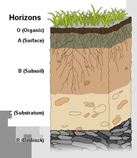
WSoil fertility refers to the ability of soil to sustain agricultural plant growth, i.e. to provide plant habitat and result in sustained and consistent yields of high quality. A fertile soil has the following properties:The ability to supply essential plant nutrients and water in adequate amounts and proportions for plant growth and reproduction; and The absence of toxic substances which may inhibit plant growth.
 W
WSoil moisture sensors measure the volumetric water content in soil. Since the direct gravimetric measurement of free soil moisture requires removing, drying, and weighing of a sample, soil moisture sensors measure the volumetric water content indirectly by using some other property of the soil, such as electrical resistance, dielectric constant, or interaction with neutrons, as a proxy for the moisture content.
 W
WSoil salinity control relates to controlling the problem of soil salinity and reclaiming salinized agricultural land.
 W
WPesticides are substances that are meant to control pests. The term pesticide includes all of the following: herbicide, insecticides nematicide, molluscicide, piscicide, avicide, rodenticide, bactericide, insect repellent, animal repellent, antimicrobial, and fungicide. The most common of these are herbicides which account for approximately 80% of all pesticide use. Most pesticides are intended to serve as plant protection products, which in general, protect plants from weeds, fungi, or insects. As an example - The fungus Alternaria is used to combat the Aquatic weed, Salvinia.
 W
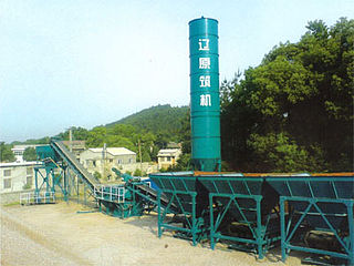
WA stabilized soil mixing plant is a combination of kinds of machines used for mixing stabilized soil, which is used for highway construction, municipal road projects, and fertile airport areas. The plant produces stabilized soil with different gradings in a continuous way. Such a plant usually contains a cement silo, measuring and conveying system, and mixing devices.
 W
WStrip cropping is a method of farming which involves cultivating a field partitioned into long, narrow strips which are alternated in a crop rotation system. It is used when a slope is too steep or when there is no alternative method of preventing soil erosion. The most common crop choices for strip cropping are closely sown crops such as hay, wheat, or other forages which are alternated with strips of row crops, such as corn, soybeans, cotton, or sugar beets. The forages serve primarily as cover crops. In certain systems, strips in particularly eroded areas are used to grow permanent protective vegetation; in most systems, however, all strips are alternated on an annual basis.
 W
WTopsoil is the upper, outermost layer of soil, usually the top 5–10 inches (13–25 cm). It has the highest concentration of organic matter and microorganisms and is where most of the Earth's biological soil activity occurs. Topsoil is composed of mineral particles, organic matter, water, and air. Organic matter varies in quantity on different soils. The strength of soil structure decreases with the presence of organic matter, creating weak bearing capacities. Organic matter condenses and settles in different ways under certain conditions, such as roadbeds and foundations. The structure becomes affected once the soil is dehydrated. Dehydrated topsoil volume substantially decreases and may suffer wind erosion.
 W
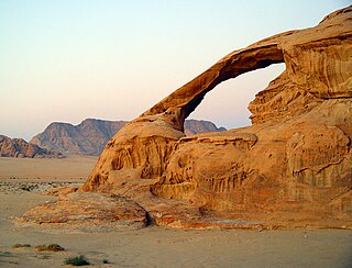
WWeathering is the breaking down of rocks, soils, and minerals as well as wood and artificial materials through contact with the Earth's atmosphere, water, and biological organisms. Weathering occurs in situ, that is, in the same place, with little or no movement, and thus should not be confused with erosion, which involves the transport of rocks and minerals by agents such as water, ice, snow, wind, waves and gravity and then being transported and deposited in other locations.
 W
WThe World Soil Museum (WSM) displays physical examples of soil profiles (monoliths) representing major soil types of the world, from the volcanic ash soils from Indonesia to the red, strongly weathered soils from the Amazon region. The museum is managed by ISRIC - World Soil Information, legally registered as the International Soil Reference and Information Centre (ISRIC), an independent, science-based foundation. Physically, the museum is located on the campus of Wageningen University and Research Centre in Wageningen, The Netherlands.