 W
WThis is a list of some aquifers in the United States.
 W
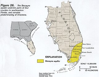
WThe Biscayne Aquifer, named after Biscayne Bay, is a surficial aquifer. It is a shallow layer of highly permeable limestone under a portion of South Florida. The area it underlies includes Broward County, Miami-Dade County, Monroe County, and Palm Beach County, a total of about 4,000 square miles (10,000 km2).
 W
WThe Columbia Plateau Aquifer system is a series of layered aquifers across ~44,000 mi2 of Washington, Oregon, and Idaho. The aquifer system is on the Columbia Plateau, contained within the Cascades, Rocky Mountains, Okanogan Highlands, and the Blue Mountains. These aquifers are bounded on the bottom by a layer of Miocene basaltic rock that can be up to 15,000 ft thick. The primary aquifers in the system are shallow, and unconfined.
 W
WThe Edwards Aquifer is one of the most prolific artesian aquifers in the world. Located on the eastern edge of the Edwards Plateau in the U.S. state of Texas, it is the source of drinking water for two million people, and is the primary water supply for agriculture and industry in the aquifer's region. In addition, the Edwards Aquifer feeds the Comal and San Marcos springs, provides springflow for recreational and downstream uses in the Nueces, San Antonio, Guadalupe, and San Marcos river basins, and is home to several unique and endangered species.
 W
WThe Fox Hills Formation is a Cretaceous geologic formation in the northwestern Great Plains of North America. It is present from Alberta on the north to Colorado in the south.
 W
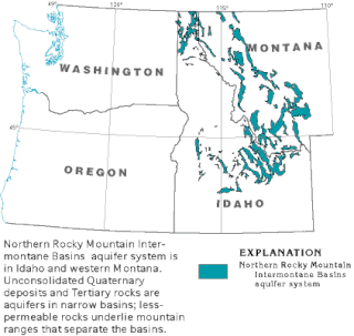
WThe Northern Rocky Mountain Intermontane Basins aquifer system is composed largely of unconsolidated sand lying under western Montana, Idaho and a small part of Washington. These shallow aquifers are not connected as a whole, body of water, but narrow glacial deposits unified by a common geologic history.
 W
WThe Ogallala Aquifer is a shallow water table aquifer surrounded by sand, silt, clay, and gravel located beneath the Great Plains in the United States. One of the world's largest aquifers, it underlies an area of approximately 174,000 sq mi (450,000 km2) in portions of eight states. It was named in 1898 by geologist N. H. Darton from its type locality near the town of Ogallala, Nebraska. The aquifer is part of the High Plains Aquifer System, and rests on the Ogallala Formation, which is the principal geologic unit underlying 80% of the High Plains.
 W
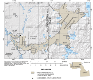
WThe Spokane Valley–Rathdrum Prairie Aquifer is an aquifer located in the U.S. states of Washington and Idaho The aquifer is centralized under Spokane Valley and the Rathdrum Prairie, hence the name. The aquifer contains 10 trillion gallons of water, and is part of the Columbia River Drainage Basin. The only watercourse that remains above the surface for an extended distance is the Spokane River. The area surrounding it receives an average of 15–30 inches (38–76 cm) of rain annually. The aquifer is the primary water source for the greater Spokane area, which is home to over 700,000 people.
 W
WWekepeke is the name of an aquifer and brook in Sterling, Massachusetts, United States. The aquifer has a land surface area of 11.5 square miles (30 km2).
 W
WThe Willamette Lowland basin-fill aquifer is 31,000 km2, 12,000 square mile aquifer underlying the region of Oregon and parts of Washington (state) between the Oregon Coast Range and the Cascade Range. The aquifer shares a name with the local river, the Willamette River, originating from a Clackamas Chinook word. The "mette" of Willamette was used by the Clackamas to mean water or river. The Willamette valley is home to 70% of Oregon's population, with the aquifer supplying water for agricultural, domestic, and industrial purposes. Reported in 2005, the total water use from the aquifer was 1.6 hm3 per day, with 58% going to irrigation, 24% to public supply, and 18% to industrial use. In general, the aquifer withdraw is sufficiently compensated in the long term by recharge through precipitation, however regions of the aquifer have shown long term declines, including that regions underlain by the Columbia River basalt unit. However, during the dry season from June-September, withdrawals from the aquifer result is significant seasonal variations in the ground water table height, changing by more than 60 ft. In the state of Oregon, all water is publicly owned and maintenance and protection of water is done by the Oregon Water Resources Department and the Oregon Water Resources Commission. However, local governments can provide land use permits for aquifer use, notably, use for new rural residences.