 W
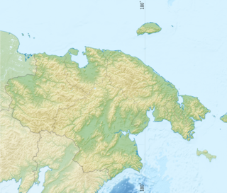
WThe Anadyr is a river in the far northeast Siberia which flows into the Gulf of Anadyr of the Bering Sea and drains much of the interior of Chukotka Autonomous Okrug. Its basin corresponds to the Anadyrsky District of Chukotka.
 W
WThe Fish River is a waterway in the U.S. state of Alaska. The 47-mile-long (76 km) river rises in the Bendeleben Mountains and flows south to Golovnin Lagoon, before emptying into Golovnin Bay, Norton Sound, and the Bering Sea. The basin formed by the Fish River is known for its placer gold deposits, and in particular, the Niukluk River and its tributaries; production from this tributary valley is reported to be more than from any other place in the region. A galena mine existed 40 miles (64 km) from the sea, worked on occasion by a San Francisco corporation with a few hundred tons of ore taken to the city for smelting and refining for silver. Walter Curran Mendenhall found obscure fossils on Fish River at White Mountain.
 W
WThe Kanchalan is a river in the Russian Far East. It passes through the sparsely populated areas of the Anadyr Lowlands and flows southwards into the Bering Sea at the Gulf of Anadyr through the Anadyrsky Liman. It is 426 kilometres (265 mi) long, and has a drainage basin of 20,600 square kilometres (8,000 sq mi).
 W
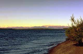
WThe Kuskokwim River or Kusko River is a river, 702 miles (1,130 km) long, in Southwest Alaska in the United States. It is the ninth largest river in the United States by average discharge volume at its mouth and seventeenth largest by basin drainage area.
 W
WThe Kuzitrin River is a stream, 95 miles (153 km) long, on the Seward Peninsula in the U.S. state of Alaska. It begins at Kuzitrin Lake in the central region of the peninsula and flows 95 miles (153 km) west into the Imuruk Basin. The basin drains via the bay of Port Clarence to the Bering Sea. Kuzitrin tributaries include the Noxapaga, Kougarok, Kruzgamepa (Pilgrim), and Kugruk rivers.
 W
WThe Tretya Rechka is a stream in the Beringovsky District of Chukotka Autonomous Okrug, Russia. It is 99 kilometres (62 mi) long. It drains part of the southern Anadyr Lowlands. It flows northeast and then northwest into the Anadyr Estuary. To the east of the Tretya is the Avtatkuul zakaznik protected area. To the south is the Tumanskaya.
 W
WThe Tubutulik River is a waterway in the U.S. state of Alaska. The 25-mile (40 km) long river is situated on the Seward Peninsula. It flows southeastwards to the Kwiniuk Inlet at the northwestern end of Norton Bay, 25 miles (40 km) southwest of Koyuk in the Bering Sea. Its Inuit name was reported as "Tubuktulik" in 1849 by Capt. Mikhail Dmitrievich Tebenkov of the Imperial Russian Navy. Exploration for placer gold occurred in the Council district area where the river valley is located, and in 1898, mining commenced. The production was substantial and ranked second only to that of Nome.
 W
WThe Tumanskaya is a river in Far East Russia. It flows through the Anadyr Lowlands, a region of wetlands and tundra, and into the Bering Sea at the Tymna lagoon. It is 268 kilometres (167 mi) long, and has a drainage basin of 9,270 square kilometres (3,580 sq mi).
 W
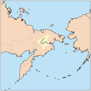
WThe Velikaya, is a river in Chukotka Autonomous Okrug in Russia. It is 451 kilometres (280 mi) long, and has a drainage basin of 31,000 square kilometres (12,000 sq mi).
 W
WThe Yukon River is a major watercourse of northwestern North America. The river's source is in British Columbia, Canada, from which it flows through the Canadian Yukon Territory. The lower half of the river lies in the U.S. state of Alaska. The river is 3,190 kilometres (1,980 mi) long and empties into the Bering Sea at the Yukon–Kuskokwim Delta. The average flow is 6,430 m3/s (227,000 ft3/s). The total drainage area is 832,700 km2 (321,500 mi2), of which 323,800 km2 (126,300 mi2) is in Canada. The total area is more than 25% larger than Texas or Alberta.