 W
WThe French Broad River flows 218 miles (351 km) from near the town of Rosman in Transylvania County, North Carolina, into the state of Tennessee. Its confluence with the Holston River at Knoxville is the beginning of the Tennessee River. The river flows through the counties of Transylvania, Buncombe, Henderson, and Madison in North Carolina, and Cocke, Jefferson, Sevier, and Knox in Tennessee, and drains large portions of the Pisgah National Forest and the Cherokee National Forest.
 W
WDavy Crockett Lake is a 383-acre body of water impounded by Nolichucky Dam on the Nolichucky River, 7 miles (11 km) south of Greeneville in Greene County in the U.S. state of Tennessee. It is also known as the Davy Crockett Reservoir and is maintained by the Tennessee Valley Authority (TVA). It is a recreation site home to a variety of game fish.
 W
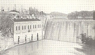
WDouglas Dam is a hydroelectric dam on the French Broad River in Sevier County, Tennessee, in the southeastern United States. The dam is operated by the Tennessee Valley Authority (TVA), which built the dam in record time in the early 1940s to meet emergency energy demands at the height of World War II. Douglas Dam is a straight reinforced concrete gravity-type dam 1705 feet long and 202 feet high, impounding the 28,420-acre (11,500 ha) Douglas Lake. The dam was named for Douglas Bluff, a cliff overlooking the dam site prior to construction.
 W
WDouglas Lake, also called Douglas Reservoir, is a reservoir created by an impoundment of the French Broad River in Eastern Tennessee. This lake is located only a few miles from the Pigeon Forge/Gatlinburg area, and also the Great Smoky Mountains National Park. See also, Douglas Dam for more information.
 W
WThe Little Pigeon River is a river located entirely within Sevier County, Tennessee. It rises from a series of streams which flow together on the dividing ridge between the states of Tennessee and North Carolina inside the boundary of the Great Smoky Mountains National Park. The river is subdivided with three separate tributaries: East, Middle, and West.
 W
WNolichucky Dam is a dam on the Nolichucky River near Greeneville, Tennessee, maintained by the Tennessee Valley Authority (TVA). The dam is located just over 46 miles (74 km) upstream from the mouth of the Nolichucky, and impounds Davy Crockett Lake, which extends 6 miles (9.7 km) upstream from the dam.
 W
WThe Nolichucky River is a 115-mile (185 km) river that flows through Western North Carolina and East Tennessee, in the southeastern United States. Traversing the Pisgah National Forest and the Cherokee National Forest in the Blue Ridge Mountains, the river's watershed is home to some of the highest mountains in the Appalachians, including Mount Mitchell in North Carolina, the highest point in the eastern United States. The river is a tributary of the French Broad River, and is impounded by Nolichucky Dam near Greeneville, Tennessee.
 W
WThe North Toe River is a large stream in the North Carolina High Country. The name Toe is taken from its original name Estatoe, pronounced 'S - ta - toe', a native American name associated with the Estatoe trade route leading down from the North Carolina mountains through Brevard. There is a historical plaque in Brevard with information that affirms the route, which continues into South Carolina, where a village of the same name was located. Due to difficulty in pronouncing the name it was shortened over the years to Toe.
 W
WThe Pigeon River of Western North Carolina and East Tennessee rises above Canton, North Carolina, is impounded by Walters Dam, enters Tennessee, and flows into the French Broad River, just past Newport, Tennessee. The river traverses the Pisgah National Forest and the Cherokee National Forest, and drains much of the northeastern Great Smoky Mountains National Park.
WWalters Dam is a hydroelectric dam in Haywood County of western North Carolina, in the Great Smoky Mountains.