 W
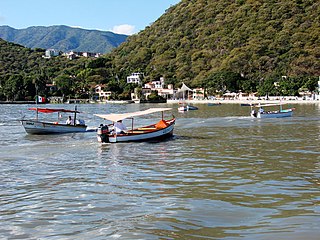
WBahía de Banderas is a bay on the Pacific Coast of Mexico, within the Mexican states of Jalisco and Nayarit. It is also the name of an administrative municipality, located on the bay in Nayarit state. The port and resort city of Puerto Vallarta is on the bay.
 W
WBarranca de Oblatos, also known as Barranca de Huentitán, is a canyon carved by the Río Grande de Santiago in Mexico in the state of Jalisco. It lies on the northeast side of the municipality of Guadalajara and on the edge of the municipalities of Tonalá, Zapotlanejo, Ixtlahuacán del Río and Zapopan in the Guadalajara Metropolitan Area. Its beauty and structure make it a slightly smaller scale version of the Grand Canyon in the United States, and Barranca del Cobre in Chihuahua.
 W
WCabo Corrientes is a cape on the Pacific coast of the Mexican state of Jalisco. It marks the southernmost point of the Bahía de Banderas, upon which the port and resort city of Puerto Vallarta stands. The municipality in which the cape lies is also called Cabo Corrientes.
 W
WThe Cerro El Huehuentón is the highest peak of the Sierra de Quila; it stands at 8,298 ft above sea level. El Huehuentón is located at about a 30-minute drive from Lagunillas, the largest population enclaved in the forest, between the municipalities of San Martín de Hidalgo and Tecolotlán, in Jalisco.
 W
WJuanacatlán Falls is a waterfall on the Santiago River in the Mexican state of Jalisco, once known as the Niagara of Mexico. Decreased flow in the Santiago River has left the falls now virtually extinct.
 W
WLake Chapala is Mexico's largest freshwater lake. It lies in the municipalities of Chapala, Jocotepec, Poncitlán, and Jamay, in Jalisco, and in Venustiano Carranza and Cojumatlán de Régules, in Michoacán.
 W
WThe Central Mexican Plateau, also known as the Mexican Altiplano, is a large arid-to-semiarid plateau that occupies much of northern and central Mexico. Averaging 1,825 m (5,988 ft) above sea level, it extends from the United States border in the north to the Trans-Mexican Volcanic Belt in the south, and is bounded by the Sierra Madre Occidental and Sierra Madre Oriental to the west and east, respectively.
 W
WThe Sierra Madre Occidental is a major mountain range system of the North American Cordillera, that runs northwest–southeast through northwestern and western Mexico, and along the Gulf of California. The Sierra Madre is part of the American Cordillera, a chain of mountain ranges (cordillera) that consists of an almost continuous sequence of mountain ranges that form the western 'backbone' of North America, Central America, South America and West Antarctica.
 W
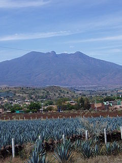
WStanding at a height of 2,920 meters above sea level, the Tequila Volcano, or Volcán de Tequila is a Stratovolcano located near Tequila, Jalisco, in Mexico. Stratovolcanoes, also referred to as Composite Volcanoes, are the "iconically" conical-shaped volcanoes, found most commonly along subduction zones. Stratovolcanoes are composed of steeply dipping layers of lava, hardened ash, and other material that erupted from the main vent such as tephra and pumice. Commonly higher than 2500 meters above sea-level, Stratovolcanoes have gentle lower slopes which gradually become steeper the higher you get with a relatively small summit crater. Due to their eruptions, Stratovolcanoes have several distinct variations giving some a specific feature such as calderas and amphitheaters.
 W
WThe Volcán de Colima, 3,820 m (12,533 ft), also known as Volcán de Fuego, is part of the Colima Volcanic Complex (CVC) consisting of Volcán de Colima, Nevado de Colima and the eroded El Cántaro. It is the youngest of the three and as of 2015 is one of the most active volcanos in Mexico and in North America. It has erupted more than 40 times since 1576. One of the largest eruptions was on January 20–24, 1913. Nevado de Colima, also known as Tzapotépetl, lies 5 kilometres (3.1 mi) north of its more active neighbor and is the taller of the two at 4,271 meters (14,015 ft). It is the 26th-most prominent peak in North America.