 W
WAgus River is a river that flows for 36.5 kilometres (22.7 mi) from Lanao Lake to Iligan Bay, Philippines. It cuts through the provinces of Lanao del Sur and Lanao del Norte. Settlements along the banks of the river include the City of Marawi, the Municipality of Linamon and the City of Iligan. It separates into two channels as it drains to Iligan Bay; one going over the Maria Cristina Falls while the other supplies the Tinago Falls. The river descends for about 2,200 feet (670 m) from its source as it flows for 21 miles (34 km) before draining to the sea. The river is relatively shallow as it is only 4 feet (1.2 m) deep in some areas. The Agus River's watershed spans about 11,320.00 hectares. In 1992, the National Power Corporation financed the reforestation of the Lake Lanao-Agus River watershed, planting over 1500 hectares of Acacia mangium, Durio zibethinus and other indigenous trees. It has a discharge of about 10 cubic metres per second (350 cu ft/s) and flows from a narrow depression off the northwestern rim of the lake and flows over a basalt rock formation. The canyon carved by the river suggests a short erosional period.
 W
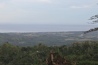
WIllana Bay, also known as the Iranun Bay, is a large bay of the Moro Gulf, off the southwestern coast of Mindanao island in the Philippines.
 W
WLake Dapao is a deep water lake located in the province of Lanao del Sur, southwest of Lake Lanao, in the island of Mindanao in the Philippines. It is one of the deepest lakes in the country, reaching a maximum depth of 120 metres (390 ft). It has an estimated surface area of 1,011 hectares (10.11 km2). The lake receives water from local run-off and several small rivers.
 W
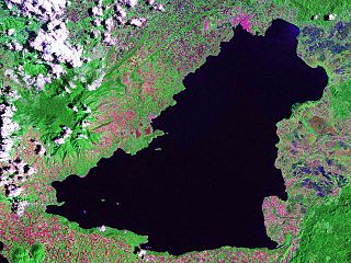
WLake Lanao is a large ancient lake in the Philippines, located in Lanao del Sur province in the country's southern island of Mindanao. With a surface area of 340 km2 (130 sq mi), it is the largest lake in Mindanao, and the second largest lake in the Philippines and counted as one of the 15 ancient lakes in the world. Scholars have been pushing for the lake's inclusion in the UNESCO World Heritage List.
WLatukan volcano is a potentially active stratovolcano in the centre of a chain of young E-W-trending stratovolcanoes in northwest Mindanao, southeast of Lake Lanao, province of Lanao del Sur, island of Mindanao, in the Bangsamoro Autonomous Region in Muslim Mindanao.
WMaradugao River is a river that serves as a natural boundary between the provinces of Bukidnon and Lanao del Sur in Mindanao in southern Philippines. It joins the Pulangi River in Cotabato.
 W
WThe Moro Gulf is the largest gulf in the Philippines. It located off the coast of Mindanao Island, and is part of the Celebes Sea. The gulf is one of the country's tuna fishing grounds.
WMount Baya is a dormant volcano in the municipality of Ganassi in Lanao del Sur province, Philippines. The mountain has a peak elevation of 1,484 meters (4,869 ft) rising from a plateau of about 950 meters (3,120 ft). It is located about 4 kilometers (2.5 mi) east of Lake Dapao and about 4.5 kilometers (2.8 mi) southwest of Lake Lanao. Between Lake Dapao and Mount Baya is Mount Gadungan, another inactive volcano.
WMakaturing, is a stratovolcano on Mindanao island in the Philippines. It is found in the province of Lanao del Sur in the Bangsamoro Autonomous Region in Muslim Mindanao. Makaturing has an elevation of 1,940 metres (6,365 ft) and a base diameter of 29 km (18 mi). It is part of a string of volcanoes called the Central Mindanao Arc.
 W
WMount Ragang, also called Mount Piapayungan and Blue Mountain by the local people, is a stratovolcano on Mindanao island in the Philippines. It is the seventh highest mountain in the Philippines and the highest point in Lanao del Sur.