 W
WCape Crawford is a location in the Northern Territory.
 W
WChambers Pillar is a sandstone formation some 160 km (100 mi) south of Alice Springs in the Northern Territory of Australia.
 W
WThe Great Artesian Basin (GAB), located in Australia, is the largest and deepest artesian basin in the world, stretching over 1,700,000 square kilometres (660,000 sq mi), with measured water temperatures ranging from 30–100 °C (86–212 °F). The basin provides the only source of fresh water through much of inland Australia.
 W
WHenbury Meteorites Conservation Reserve is a protected area in the Northern Territory of Australia located in the locality of Ghan.
 W
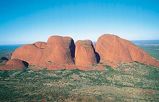
WKata Tjuṯa,, also known as the Olgas, is a group of large, domed rock formations or bornhardts located about 360 km (220 mi) southwest of Alice Springs, in the southern part of the Northern Territory, central Australia. Uluru, also known as Ayers Rock, located 25 km (16 mi) to the east, and Kata Tjuṯa form the two major landmarks within the Uluru-Kata Tjuṯa National Park. The park is considered sacred to the Aboriginal people of Australia.
 W
WThe Lake Eyre basin is a drainage basin that covers just under one-sixth of all Australia. It is the largest endorheic basin in Australia and amongst the largest in the world, covering about 1,200,000 square kilometres (463,323 sq mi), including much of inland Queensland, large portions of South Australia and the Northern Territory, and a part of western New South Wales. The basin is also one of the largest, least-developed arid zone basins with a high degree of variability anywhere. It supports about 60,000 people and a large amount of wildlife, and has no major irrigation, diversions or flood-plain developments. Low density grazing is the major land use, occupying 82% of the total land within the basin.
 W
WBurrunggui is located in an outlying sandstone formation of the Arnhem Land Escarpment within the Kakadu National Park in the Northern Territory of Australia. It is the traditional Country of the Gun-djeihmi speaking people and according to Traditional Owners, was shaped by Ancestral beings in the creation period of the Dreaming. It was included on the World Heritage Register. Kakadu National Park is included on UNESCO the World Heritage List due to its exceptional natural and cultural values.
 W
WStandley Chasm is a geological formation located west of Alice Springs in the Northern Territory. It lies within the West MacDonnell National Park. The Western Arrernte Aboriginal people are its original owners; it is traditionally known as Angkerle Atwatye, meaning the Gap of Water. Standley Chasm is located in a reserve privately owned by the Iwupataka Land Trust.
 W
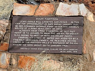
WTjunti is a soakage site near Kaḻṯukatjara, in the Northern Territory of Australia. It is located where the Hull River cuts through the Petermann Ranges, about 36 kilometres (22 mi) to the southeast of Kaḻṯukatjara, 41 km (25 mi) by road along the Tjukaruru Road. Tjunti is known as the site where the famous gold prospector Harold B. Lasseter took refuge on his fatal search for Lasseter's Reef. An outstation was established here in 1977, and belongs to a Pitjantjatjara family.
 W
WUbirr is a rock formation within the East Alligator region of Kakadu National Park in the Northern Territory of Australia, and is known for its rock art. It consists of a group of rock outcrops on the edge of the Nadab floodplain where there are several natural shelters that have a collection of Aboriginal rock paintings, some of which are many thousands of years old. The art depicts certain creation ancestors as well as animals from the area such as barramundi, catfish, mullet, goannas, long-necked turtles, pig-nosed turtles, rock ringtail possums, and wallabies.