 W
WThe principal tributaries of the Chao Phraya River of Thailand are the Pa Sak River, the Sakae Krang River, the Nan River, the Ping River, and the Tha Chin River. Each of these tributaries is further tributed by additional minor tributaries often referred to as khwae. All of the tributaries, including the lesser khwae, form an extensive tree-like pattern, with branches flowing through nearly every province in central and northern Thailand.. None of the tributaries of the Chao Phraya extend beyond the nation's borders. The Nan and the Yom River flow nearly parallel from Phitsanulok to Chumsaeng in the north of Nakhon Sawan province. The Wang River enters the Ping River near Sam Ngao district in Tak province.
 W
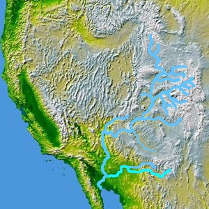
WThe principal tributaries of the Colorado River of North America are the Gila River, the San Juan River, the Green River, and the Gunnison River.
 W
WTributaries and sub-tributaries are hierarchically listed in order from the mouth of the Columbia River upstream. Major dams and reservoir lakes are also noted.
 W
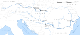
WThis is a list of tributaries of the Danube by order of entrance.
 W
WThis is a List of tributaries of the Gila River, the final river drainage of the Colorado River, and covers the entire width of southern Arizona. The headwaters of the Gila River begin in the Gila National Forest of New Mexico. The northern branch tributary to the Gila River in the Gila National Forest, is the San Francisco River.
 W
WThe Loire's tributaries include the following rivers, in order going upstream:
 W
WTributaries of the Missouri River, a major river in the central United States, are listed in upstream order. These lists are arranged into river sections between cities or mouths of major tributaries for ease of navigation. Two large tributaries have their own separate lists because they would be too lengthy to include in part of another section.
 W
WThis is a list of the Tributaries of the Niger River. They are listed by nation, at the point they converge into the Niger.
 W
WThis is a list of tributaries of the Río de la Plata, or rivers of the La Plata Basin. Tributaries and sub-tributaries are hierarchically listed in order from the mouth of the Río de la Plata upriver. The terms "right" and "left" indicate on which side of the main stem river a tributary is located, from the perspective of looking downriver, following standard river bank terminology usage. Countries are identified in abbreviated form: AR for Argentina, UY for Uruguay, PY or PA for Paraguay, BR for Brazil, and BO for Bolivia. Major dams are also noted.Salado River: right; AR; 35°44′44″S 57°21′51″W ; Río Salado at GEOnet Names Server. Rio Vallimanca: right; AR. Samborombón River: right; AR; 35°43′0″S 57°20′50″W ; GNS: Río Samborombón at GEOnet Names Server. Santa Lucía River: left; UR. Matanza River (Riachuelo): right; AR; 34°37′57″S 58°20′46″W; Río Matanza at GEOnet Names Server. Luján River: right; AR; 34°25′55″S 58°32′28″W; Río Luján at GEOnet Names Server. Reconquista River: right; AR San Juan River (Uruguay): left; UR; 34°16′26″S 57°59′21″W; Río San Juan at GEOnet Names Server.Uruguay River: left; AR, UY, BR; 35°43′0″S 57°20′50″W; GNS: Uruguay River at GEOnet Names Server, Río Uruguay at GEOnet Names Server, Rio Uruguai at GEOnet Names Server. San Salvador River (Uruguay): left; UY. Río Negro (Uruguay): left; UY; 33°25′S 58°25′W; GNS: Rio Negro at GEOnet Names Server. Yí River: left; UY; 33°6′50″S 57°6′46″W; Río Yi at GEOnet Names Server. Porongos River: left; UY. Chamangá River: left; UY. Gualeguaychú River: right; AR; 33°4′45″S 58°25′0″W; Río Gualeguaychú at GEOnet Names Server. Queguay Grande River: right; UY. Queguay Chico River: right; UY. Daymán River: right; UY; 31°30′16″S 58°1′56″W; Río Daymán at GEOnet Names Server. Salto Grande Dam: AR, UY. Arapey Grande River: right; UY Arapey Chico River: right; UY. Mocoretá River: right; AR. Miriñay River: right; AR; 30°10′12″S 57°37′59″W; Miriñay Río at GEOnet Names Server. Quaraí River : left; UY, BR (border); 30°11′5″S 57°36′18″W; Río Cuareim at GEOnet Names Server. Ibicuí River: left; BR; 29°25′16″S 56°46′20″W; Rio Ibicuí at GEOnet Names Server. Itu River: right; BR; 29°24′37″S 55°51′2″W; Rio Itu at GEOnet Names Server. Santa Maria River : left Ibicuí source; BR; 29°48′13″S 54°55′20″W; Rio Santa Maria at GEOnet Names Server. Ibicuí-Mirim River: right Ibicuí source; BR; 29°48′14″S 54°55′16″W; Rio Ibicuí-Mirim at GEOnet Names Server. Aguapey River: right; AR; 29°6′39″S 56°35′6″W; Río Aguapey at GEOnet Names Server. Icamaquã River: left; BR; 28°34′2″S 56°0′13″W; Rio Icamaquã at GEOnet Names Server. Ijuí River: left; BR; 27°58′3″S 55°20′1″W; Rio Ijuí at GEOnet Names Server. Santa Rosa River : left; BR; 27°33′28″S 54°39′57″W; Rio Santa Rosa at GEOnet Names Server. Pepiri-Guazu River : right; AR, BR (border); 27°10′S 53°50′W; Río Pepirí Guazú at GEOnet Names Server, Rio Peperi Guaçu at GEOnet Names Server. Guarita River: left; BR. Das Antas River : right; BR. Da Várzea River : left; BR; 27°12′48″S 53°19′33″W; Rio da Várzea at GEOnet Names Server. Chapecó River: right; BR; 27°5′43″S 53°0′57″W; Rio Chapecó at GEOnet Names Server. Chapecozinho River: left; BR. Passo Fundo River: left; BR; 27°17′8″S 52°41′26″W; Rio Passo Fundo at GEOnet Names Server. Irani River: right; BR; 27°14′23″S 52°32′38″W; Rio Irani at GEOnet Names Server. Do Peixe River : right; BR. Forquetinha River: left; BR. Canoas River : right Uruguay source; BR; 27°36′21″S 51°27′20″W; Rio Canoas at GEOnet Names Server. Campos Novos Dam: BR. Caveiras River: left; BR. Marombas River: right; BR ; 27°25′18″S 50°45′16″W; Rio Marombas at GEOnet Names Server. Pelotas River: left Uruguay source; BR; 27°36′31″S 51°27′22″W; Rio Pelotas at GEOnet Names Server. Vacas Gordas River: BR Pelotinhas River: BR Lava-Tudo River: BR São Mateus River : BR Antoninha River: BR Da Divisa River: BR Sumidouro River: BR Púlpito River: BRParaná River: right; AR, PA, BR; 34°0′5″S 58°23′37″W; GNS: ??. Arrecifes River: right; AR; 33°45′19″S 59°34′11″W; Río Arrecifes at GEOnet Names Server. Gualeguay River: left; AR; 33°19′0″S 59°38′0″W; Río Gualeguay at GEOnet Names Server. Nogoya River: left; AR; 32°55′S 59°59′W; Arroyo Nogoyá at GEOnet Names Server, Río Nogoyá at GEOnet Names Server. Arroyo del Medio; right; AR. Saladillo Stream : right; AR; 32°59′54″S 60°36′42″W; Arroyo Saladillo at GEOnet Names Server, Río Saladillo at GEOnet Names Server. Ludueña Stream: right; AR; 32°54′23″S 60°40′34″W; Arroyo Ludueña at GEOnet Names Server. Carcarañá River: right; AR; 32°26′32″S 60°48′13″W; Río Carcarañá at GEOnet Names Server. Tercero River : left Carcarañá source; AR; 32°54′54″S 62°19′29″W; Río Tercero at GEOnet Names Server. Cuarto River : right Carcarañá source; AR; 32°54′55″S 62°19′29″W; Río Cuarto at GEOnet Names Server. Salado River (Argentina) : right; AR; 31°41′2″S 60°44′33″W; Río Salado at GEOnet Names Server, Río Pasaje at GEOnet Names Server, Río Juramento at GEOnet Names Server. Horcones River : right; AR ; 26°35′S 63°58′W; Río Horcones at GEOnet Names Server, Río Rosario at GEOnet Names Server. Urueña River: right; AR ; 26°14′S 64°30′W; Río Urueña at GEOnet Names Server. Arenales River Rosario River Guasamayo River Feliciano River: left; AR; 31°5′25″S 59°53′46″W; Arroyo Feliciano at GEOnet Names Server. Guayquiraró River: left; AR; 30°24′46″S 59°34′47″W; Río Guayquiraró at GEOnet Names Server. Corrientes River: left, AR; 30°0′38″S 59°33′21″W; Río Corrientes at GEOnet Names Server. Paraná Miní River: right; AR; 29°5′9″S 59°24′21″W; Río Paraná Miní at GEOnet Names Server. Tapenagá River: right; AR; 28°4′46″S 59°9′18″W; Río Tapenagá at GEOnet Names Server. Palometa River: right; AR; 27°55′56″S 59°6′8″W; Riacho Palometa at GEOnet Names Server. Santa Lucía River: left; AR; 29°4′43″S 59°14′9″W; Río Santa Lucía at GEOnet Names Server. Negro River (Chaco): right; AR (Chaco); 27°28′8″S 58°53′48″W; Río Negro at GEOnet Names Server. Guaycurú River: right; AR (Chaco).Paraguay River: right; AR, PA, BR; 27°17′21″S 58°36′29″W; GNS: Río Paraguay at GEOnet Names Server. Río de Oro: right; AR; 27°4′S 58°34′W; Río de Oro at GEOnet Names Server. Bermejo River : right; AR, BO; 26°52′S 58°23′W; GNS: Río Bermejo at GEOnet Names Server. Bermejito River: right (anabranch); AR; 25°39′S 60°11′W; GNS: Río Bermejito at GEOnet Names Server. Dorado River Teuquito River Seco River San Francisco River: right; AR ; 23°18′15″S 64°4′45″W; Río San Francisco at GEOnet Names Server. Grande River Mojotoro River Pescado River: right; AR; 22°59′48″S 64°20′12″W; Río Pescado at GEOnet Names Server. Iruya River: left; AR; 22°20′12″S 64°5′52″W; Río Itaú at GEOnet Names Server. Río Grande de Tarija: left; AR; 22°55′37″S 64°20′11″W; Río Grande de Tarija at GEOnet Names Server. Itaú River: left; AR and BO; 22°20′12″S 64°5′52″W; Río Itaú at GEOnet Names Server. Lipeo River: right; AR; 22°26′28″S 64°31′33″W; Río Lipeo at GEOnet Names Server. Tebicuary River; left; PY; 26°36′16″S 58°11′34″W; Río Tebicuary at GEOnet Names Server. Pilcomayo River: right; AR, BO: 25°21′S 57°40′W; Río Pilcomayo at GEOnet Names Server. Pilaya River (Bolivia) San Juan del Oro River (Bolivia) Río Grande de San Juan Confuso River: right, PA; 25°7′57″S 57°32′31″W; Río Confuso at GEOnet Names Server. Salado River (Paraguay): left; PA; 25°6′26″S 57°28′38″W; Río Salado at GEOnet Names Server. Piribebuy River: left; PY. Manduvirá River: left; PY; 24°57′30″S 57°18′28″W; Río Salado at GEOnet Names Server. Aguaray-Guazú River : right; PY Negro River (Paraguay): PY Jejuí Guazú River: left; PA. Monte Lindo River: PY Ypané River: left; PY; 23°28′39″S 57°26′32″W; Río Ypané at GEOnet Names Server. Aquidabán River: left; PY Verde River (Paraguay): PY Apa River: left, PA, BR (border); 22°5′26″S 57°59′24″W; Rio Apa at GEOnet Names Server. Perdido River : right; BR. Caracol River : right; BR. Amanguijá River: left; BR. Tarunã River: left; BR. Tererê River: left; BR. Branco River : left; BR. Aquidabã River : left; BR. Novo River : right; BR. Miranda River (Brazil): left; BR ; 19°24′46″S 57°19′55″W; Rio Miranda at GEOnet Names Server. Aquidauana River: right; BR. Salobra River: left; BR. Negro River : left; BR ; 19°14′20″S 57°13′15″W; Rio Negro at GEOnet Names Server. Taboco River: left; BR. Inhumas River : right; BR. Taquari-Mirim River : left; BR. Cuiabá River: BR; 17°9′10″S 56°38′57″W; Rio Cuiabá at GEOnet Names Server. Paraguazinho River: left; BR Cassanje River: left; BR ; Jauru River : right; BR; 16°20′41″S 57°46′55″W; Rio Jauru at GEOnet Names Server. Aguapeí River: right; BR ; 15°52′23″S 58°23′55″W; Rio Aguapeí at GEOnet Names Server. Cabaçal River: right; BR ; 15°59′52″S 57°42′19″W; Rio Cabaçal at GEOnet Names Server. Vermelho River : right; BR (MG). Sepotuba River: left; BR (MG).(Paraná River above Paraguay confluence) Yacyretá Dam: AR, PY. Iguazu River : left; BR, AR ; 25°35′33″S 54°35′27″W; Rio Iguaçu at GEOnet Names Server, Río Iguazú at GEOnet Names Server San Antonio River: left; BR, AR (border). Chopim River: left; BR. Salt Santiago Dam Jordão River (Paraná): right; BR. Iratim River: left; BR. São Francisco River (Paraná): left; BR (Paraná). Piquiri River: left; BR (Paraná); 24°1′37″S 54°5′37″W; Rio Piquiri at GEOnet Names Server. Goio-Erê River: right; BR. Cantú River: right; BR. Do Cobre River: left; BR. Ivaí River: left; BR (Paraná); 23°18′17″S 53°41′49″W; Rio Ivaí at GEOnet Names Server. Ligeiro River: left; BR. Corumbataí River (Paraná): left; BR. Ivinhema River: right; BR. Paranapanema River: left; BR ; 22°39′30″S 53°5′23″W; Rio Paranapanema at GEOnet Names Server. Rosana Dam Taquaruçu Dam Capivara Dam Tibagi River: left; BR (Paraná); 22°47′55″S 51°0′18″W; Rio Tibagi at GEOnet Names Server. Iapó River: right; BR (Paraná). Das Cinzas River: left; BR (Paraná). Laranjinha River: left; BR (Paraná). Salto Grande Dam Pardo River : right; BR ; 22°54′43″S 49°57′57″W; Rio Pardo at GEOnet Names Server. Xavantes Dam Itararé River: left: BR. Taquari-Guaçu River: left; BR. Apiai-Guaçu River: left; BR. Itapetininga River: right; BR ; 23°36′1″S 48°26′33″W; Rio Itapetininga at GEOnet Names Server. Sérgio Motta Dam Pardo River : right; BR; 21°39′51″S 52°13′27″W; Rio Pardo at GEOnet Names Server. Anhanduí River: right; BR. Do Peixe River : left; BR. Verde River : right; BR. São Domingos River : left; BR. Aguapeí River : right; BR. Eng Souza Dias (Jupiá) Dam Sucuriú River: right; BR ; 20°42′43″S 51°39′36″W; Rio Sucuriú at GEOnet Names Server. Tietê River: left; BR ; 20°37′40″S 51°33′54″W; Rio Tietê at GEOnet Names Server. Três Irmãos Dam Nova Avanhandava Dam Promissão Dam Ibitinga Dam Bariri Dam Barra Bonita Dam Piracicaba River: right; BR ; 22°36′53″S 48°19′12″W; Rio Piracicaba at GEOnet Names Server. Anhembi Dam Laras Dam Sorocaba River: left; BR; 22°58′56″S 47°48′24″W; Rio Sorocaba at GEOnet Names Server. Ituparanga Dam Sarapuí River : left; BR. Capivari River : right; BR; 22°59′3″S 47°45′51″W; Rio Capivari at GEOnet Names Server. Jundiaí River : right; BR; 23°12′41″S 47°17′34″W; Rio Jundiaí at GEOnet Names Server. Pinheiros River: left; BR ; 23°31′36″S 46°45′0″W; Rio Pinheiros at GEOnet Names Server. Rio Grande : left; São Paulo City. Guarapiranga (reservoir): São Paulo City. Billings Reservoir: São Paulo City. Ilha Solteira Dam São José dos Dourados River: left; BR ; 20°22′22″S 51°19′22″W; Rio São José dos Dourados at GEOnet Names Server. Grande River: left Paraná source; BR ; 20°4′41″S 50°59′41″W; Rio Grande at GEOnet Names Server. Água Vermelha Dam Turvo River : left; BR ; 19°56′59″S 49°53′54″W; Rio Turvo at GEOnet Names Server. Marimbondo Dam Pardo River : left; BR; 20°10′12″S 48°38′40″W; Rio Pardo at GEOnet Names Server. Moji-Guaçu River: left; BR ; 20°53′16″S 48°10′39″W; Rio Moji-Guaçu at GEOnet Names Server. Moji-Mirim River: left?; BR. Porto Colõmbia Dam Volta Grande Dam Igarapava Dam Jaguará Dam Luiz Barreto (Estreito) Dam Furnas Dam Camargos Dam Paranaíba River: right Paraná source; BR ; 20°4′43″S 51°0′22″W; Rio Iguaçu at GEOnet Names Server, Rio Paranaíba at GEOnet Names Server. Aporé River: right; BR ; 19°27′29″S 50°56′26″W; Rio Aporé at GEOnet Names Server. Corrente River : right; BR (Goiás); 19°18′42″S 50°50′19″W; Rio Corrente at GEOnet Names Server. Claro River : right; BR (Goiás); 19°7′56″S 50°38′40″W; Rio Claro at GEOnet Names Server. Doce River (Goiás): left; BR; 18°21′24″S 51°14′17″W; Rio Doce at GEOnet Names Server. São Simão Dam Tijuco River: left; BR ; 18°40′49″S 50°4′8″W; Rio Tijuco at GEOnet Names Server. Da Prata River : left; BR. Dos Bois River : right; BR (Goiás). Rio Verdão: right; BR. Meia Ponte River: right; BR (Goiás); 18°32′39″S 49°35′48″W; Rio Meia Ponte at GEOnet Names Server. Cachoeira Dourada Dam Itumbiara Dam Araguari River : left; BR; 18°20′42″S 48°38′5″W; Rio Araguari at GEOnet Names Server Uberabinha River: Quebra-Anzol River: Emborcação Dam São Marcos River: right; BR; 18°14′44″S 47°36′44″W; Rio São Marcos at GEOnet Names Server. Verde River : right; BR; 23°36′1″S 48°26′33″W; Rio Verde at GEOnet Names Server.
 W
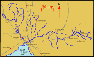
WThe Yarra River is a river in East-Central Victoria, Australia that flows through the city of Melbourne. This article contains explanations and lists of the river's tributaries and other geographic features. The river flows atop layers of silt that built up within an ancient river valley around 10,000-15,000 years ago.