 W
WThe Black Buttes, also known historically as the Sawtooth Rocks, make up an extinct stratovolcano in the Cascade Volcanic Arc in Whatcom County, Washington, United States. Glacially eroded remnants of this volcano rise above the Deming Glacier, part of the glacier system of the nearby volcano Mount Baker. There are three major peaks — Colfax, Lincoln, and Seward — which can all be climbed.
 W
WCarrizozo volcanic field is a monogenetic volcanic field located in New Mexico, US. The volcanic field consists of two lava flows, the Broken Back flow and the Carrizozo lava flow, the second youngest in New Mexico. Both lava flows originated from groups of cinder cones. The Broken Back flow is approximately 16 kilometres (10 mi) long and the Carrizozo, one of the largest in the world, is 68 kilometres (42 mi) long, covering 328 square kilometres (127 sq mi) with a volume of 4.2 cubic kilometres (1.0 cu mi).
 W
WThe Farm Creek Section, also known as the Farmdale Geologic Exposure, is a hillside near East Peoria, Illinois that clearly showed geological strata. It is nationally significant as one of the first exposed glacial stratifications in the United States to be scientifically documented. These Ice Age geological formations, with rock layers representing different periods of glaciation, had long been known and published in England, France, and Germany, but were not yet well known in North America. Geologist Frank Leverett discovered this exposed face of a hill with its clearly defined stratifications in 1879 and described and pictured it in his monograph, The Illinois Glacial Lobe, in 1899.
 W
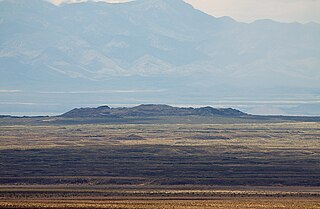
WThe Jornada del Muerto Volcano is a small shield volcano and lava field in central New Mexico, about 10 by 15 miles in size and reaching an elevation of 5,136 feet (1,565 m). Jornada del Muerto means "Dead Man's Route" in Spanish, referring to the desolate colonial era trail from New Spain through this Malpaís region.
 W
WThe Marysvale volcanic field is located in southwestern Utah, United States.
 W
WMount Sanford is a shield volcano in the Wrangell Volcanic Field, in eastern Alaska near the Copper River. It is the sixth highest mountain in the United States and the third highest volcano behind Mount Bona and Mount Blackburn. The south face of the volcano, at the head of the Sanford Glacier, rises 8,000 feet (2,400 m) in 1 mile (1,600 m) resulting in one of the steepest gradients in North America.
 W
WSanta Clara Volcano is a volcanic field and lava flow in the Diamond Valley in Washington County, Utah, United States. The most prominent features are two cinder cones that rise above Snow Canyon State Park. The southern cinder cone and most of the north cinder cone are within the boundaries of Snow Canyon State Park. The city of St. George, Utah is located in the volcanic field. The date of the last eruption is unknown.
 W
WThe Snake River Plain is a geologic feature located primarily within the U.S. state of Idaho. It stretches about 400 miles (640 km) westward from northwest of the state of Wyoming to the Idaho-Oregon border. The plain is a wide, flat bow-shaped depression and covers about a quarter of Idaho. Three major volcanic buttes dot the plain east of Arco, the largest being Big Southern Butte.
 W
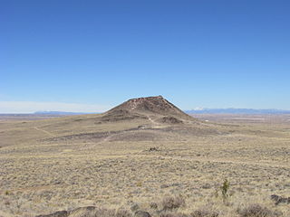
WVulcan, named after the Roman god of fire, is an inactive volcano on Albuquerque, New Mexico's West Mesa. It is the largest of the volcanoes in Albuquerque's Volcanic Field. Vulcan is a spatter cone, formed primarily by fire fountains that were active in the central vent and in smaller vents on flanks of the cone. These flank vents formed the arches and caves seen today. From a vantage point on top of the cone 600 feet above valley floor, the alignment of the 5-mile-long chain of vents is particularly noticeable. Fragmented cinder and spatter material and lava flows dip at angles as high as 55° away from the central vent on the eastern and southern side of Vulcan. The spatter material is thickest on the southeastern side of Vulcan, indicating that it was blown by the wind toward the south and east during the fountaining events. A solidified lava pond that consists of a massive gray basalt with weakly developed columnar jointing occupies the crater of Vulcan. Radial, sinuous lava tubes 8 to 20 inches across and 300 feet long are preserved on the northeast and northwest flanks of Vulcan.
 W
WThe Yellowstone hotspot is a volcanic hotspot in the United States responsible for large scale volcanism in Idaho, Montana, Nevada, Oregon, and Wyoming as the North American tectonic plate moved over it. It formed the eastern Snake River Plain through a succession of caldera-forming eruptions. The resulting calderas include the Island Park Caldera, the Henry's Fork Caldera, and the Bruneau-Jarbidge caldera. The hotspot currently lies under the Yellowstone Caldera. The hotspot's most recent caldera-forming supereruption, known as the Lava Creek eruption, took place 640,000 years ago and created the Lava Creek Tuff, and the most recent Yellowstone Caldera. The Yellowstone hotspot is one of a few volcanic hotspots underlying the North American tectonic plate; another example is the Anahim hotspot.