 W
WThe Thracian Sea is the northernmost part of the Aegean Sea. It is bounded by Macedonia and Thrace as well as northwestern Turkey. The entire area of the sea lies north of the 40th parallel. Its length from east to west is from 23°E to about 25.8°E, or from the Strymonian Gulf east to the northernmost part of the Gallipoli peninsula and the width from north to south is about 40.25°N to 41°N, or from the Dardanelles north to the boundary between the Xanthi and the Rhodope regional units. Islands includes Thasos and Samothrace in Greece and Gökçeada and Bozcaada in Turkey. The bays and gulfs includes the Ierissian Gulf to the southwest, the Strymonian Gulf where the Strymon River empties, the Kavala Gulf and the Saros Gulf in Turkey. Rivers emptying into this portion of the gulf include the Nestos and the Evros/Meriç. The famous thermal springs are Loutra Eleftheron in Kavala.
 W
WAlexandroupoli or Alexandroupolis is a city in Greece and the capital of the Evros regional unit in East Macedonia and Thrace. It has 57,812 inhabitants and is the largest city in Thrace and the region of Eastern Macedonia and Thrace. It is an important port and commercial center of northeastern Greece.
 W
WSaros Bay or Gulf of Saros is an inlet of the northern Aegean Sea located north of the Gallipoli Peninsula in northwestern Turkey. The Archipelago of Saros is in the gulf. It consists the three small islands: The Big island, The Small island and The Little island.
 W
WImbros or İmroz, officially Gökçeada since 29 July 1970, is the largest island of Turkey and the seat of Gökçeada District of Çanakkale Province. It is located in the north-northeastern Aegean Sea, at the entrance of Saros Bay, and is the westernmost point of Turkey. Imbros has an area of 279 km2 (108 sq mi) and has some wooded areas.
 W
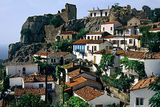
WLemnos is a Greek island in the northern part of the Aegean Sea. Administratively the island forms a separate municipality within the Lemnos regional unit, which is part of the North Aegean region. The principal town of the island and seat of the municipality is Myrina. At 477.583 square kilometres (184.396 sq mi), it is the 8th-largest island of Greece.
 W
WSamothrace is a Greek island in the northern Aegean Sea. It is a municipality within the Evros regional unit of Thrace. The island is 17 km (11 mi) long and is 178 km2 (69 sq mi) in size and has a population of 2,859. Its main industries are fishing and tourism. Resources on the island include granite and basalt. Samothrace is one of the most rugged Greek islands, with Mt. Saos and its tip Fengari rising to 1,611 m (5,285 ft).
 W
WThe Singitic Gulf, also known as the Mount Athos Gulf or the Holy Mountain Gulf is a gulf of the Thracian Sea, part of the northern Aegean Sea, in Chalkidiki, Greece. It is bounded by Sithonia in the west, and Mount Athos in the east. The island of Ammouliani sits in the northeastern portion of the gulf along Mount Athos. Many of the monasteries of Mount Athos lie along the shore of the Singitic Gulf.
 W
WThe Strymonian or Strymonic Gulf, also known as the Orfano Gulf, is a branch of the Thracian Sea—itself part of the Aegean Sea—lying east of the Chalcidice peninsula and south of the Serres regional unit. It was formerly known as the Gulf of Rendina, in reference to the ancient colony of Eion along the gulf's shores.
 W
WThasos or Thassos is a Greek island, geographically part of the North Aegean Sea, but administratively part of the Kavala regional unit, Macedonia. It is the northernmost major Greek island, and 12th largest by area. Thasos is also the name of the largest town of the island, situated at the northern side, opposite the mainland and about 10 kilometres from Keramoti. Thassos island is known from ancient times for its termae making it a climatic and balneoclimateric resort area.
 W
WThe Toronean Gulf or Toroneos Gulf, also known as the Kassandra Gulf, is a gulf of the Thracian Sea, part of the northern Aegean Sea, in Chalkidiki, Greece. It lies between the Kassandra peninsula in the west, and Sithonia in the east.