 W
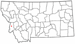
WBitterroot National Forest comprises 1.587 million acres (6,423 km²) in west-central Montana and eastern Idaho, of the United States. It is located primarily in Ravalli County, Montana, but also has acreage in Idaho County, Idaho (29.24%), and Missoula County, Montana (0.49%).
 W
WThe Anaconda–Pintler Wilderness is located in southwestern Montana, in the northwestern United States. It runs for 40 miles (64 km) along both sides of the crest of the Anaconda Range, covering almost 250 square miles (650 km2). To the north are the Sapphire Mountains, and to the south is the Big Hole Valley. Elevations range from about 5,000 feet (1,500 m) up to 10,793 feet (3,290 m) at West Goat Peak. West Pintler Peak, located in a more commonly visited area, rises to 9,894 feet (3,016 m). Visitors can most easily access this area via trailheads at Pintler Lake to the south, and at Lutz Creek and Moose Lake to the north. The wilderness lies in parts of Deer Lodge, Granite, Ravalli, and Beaverhead counties.
 W
WThe Northern and Central Bitterroot Range, collectively the Bitterroot Mountains, is the largest portion of the Bitterroot Range, part of the Rocky Mountains, located in the panhandle of Idaho and westernmost Montana in the Western United States. The mountains encompass an area of 4,862 square miles (12,593 km²).
 W
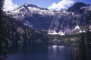
WBlodgett Canyon is located in southwestern Montana in the northwestern United States. It is one of more than two dozen scenic canyons deeply carved into the eastern flanks of the Bitterroot Range in Bitterroot National Forest. Starting from a group of peaks at over 8,500 feet along the Idaho/Montana border, the canyon steeply drops to Blodgett Lake at 6,800 feet. After running northeast for about a mile, it turns due east and descends for a total of about 12 miles (19 km) to the Bitterroot Valley. A trailhead is located at the mouth of the canyon, just west of the community of Hamilton and at an elevation of 4,000 feet (m).
 W
WElk Bath is a wildlife photograph by John McColgan, a fire behavior analyst working for the Alaska Fire Service division of the Bureau of Land Management. It was taken on August 6, 2000, on the East Fork of the Bitterroot River on the Sula Complex, Bitterroot National Forest, Montana, United States, and is also sometimes known by the title, Bitterroot Forest Fire or, more vaguely, Montana Fire. When NASA featured it in its online Astronomy Picture of the Day series, it was called Fire on Earth. The image shows two Rocky Mountain elk seeking protection from a wildfire by standing in the river.
 W
WThe Frank Church—River of No Return Wilderness Area is a protected wilderness area in Idaho. It was created in 1980 by the United States Congress and renamed in 1984 as the Frank Church-River of No Return Wilderness Area in honor of U.S. Senator Frank Church.
 W
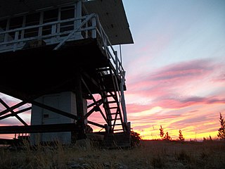
WThe Gardiner Peak Lookout, on Gardiner Peak in the West Fork District of Bitterroot National Forest, near Darby, Idaho, was built in 1953. It was listed on the National Register of Historic Places in 2018.
 W
WThe Salmon Mountain Lookout, on Salmon Mountain in the West Fork District of Bitterroot National Forest, near Darby, Idaho, was built in 1949. It was listed on the National Register of Historic Places in 2018.
 W
WThe Sapphire Mountains are a range of mountains located in southwestern Montana in the northwestern United States. From a point near the Clark Fork River and the city of Missoula, they run in a southerly direction for a distance of approximately 60 miles (100 km), making up much of the border between Ravalli County and Granite County. To the west is the Bitterroot Valley, and to the east is Rock Creek. The southern end of the range meets the larger Anaconda Range at West Pintler Peak.
 W
WThe Selway–Bitterroot Wilderness is a protected wilderness area in the states of Idaho and Montana, in the northwestern United States.
WTrapper Peak is the highest point in the Bitterroot Mountains, part of the larger Bitterroot Range in western Montana. It rises over 6,000 feet (1,830 m) above the nearby Bitterroot Valley.