 W
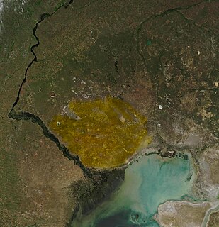
WAral Karakum is a desert in Kazakhstan, situated northeast of the Aral Sea. It borders on the Syr Darya river to the south. The desert covers an area of 40,000 km2 (15,000 sq mi).
 W
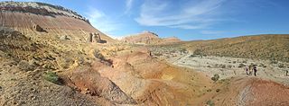
WThe Aralkum Desert is a desert that has appeared since 1960 on the seabed once occupied by the Aral Sea. It lies to the south and east of what remains of the Aral Sea in Uzbekistan and Kazakhstan.
 W
WBetpak-Dala or Betpaqdala is a desert region in Kazakhstan. It is located between the lower reaches of the Sarysu River, the Chu River, and Lake Balkhash. In the north, near the 46°30’ parallel, Betpak-Dala borders on the Kazakh melkosopochnik. Its area is approximately 75,000 km2. The desert is a flat, gently rolling plain with an elevation ranging from 300 to 350 m and a general south-western incline. Elevations are greatest in the east. In the southeast, the Zhel’tau highland reaches an elevation of 974 m at Mount Dzhambul.
 W
WThe Central Asian northern desert is an ecoregion in the deserts and xeric shrublands biome, located in the Central Asian countries of Kazakhstan and Uzbekistan. The annual precipitation ranges from 100 to 150 mm, the winters are cold at −10 to −15 °C and the summers hot at around 25 °C (77 °F). There are a range of habitat types including salt flats, clay desert, rocky desert and some sand desert. The vegetation consists of scanty xeric shrubs including Artemisia and Salsola. The fauna is varied, as well as mammals and birds, there are a large number of reptiles and many species of invertebrate. Some protected areas are included in this ecoregion but other parts are being degraded by conversion to farmland, overgrazing and poaching.
 W
WKaragiye is a 40 kilometres (25 mi) long karst trench close to the Caspian Sea. At its lowest point at Vpadina Kaundy, it is approximately 132 metres (433 ft) below sea level. It is the lowest point in Central Asia, Kazakhstan, and the former Soviet Union. It is also known as the Karagiye Depression and Karagiye Mountain Trench.
 W
WThe Karakum Desert, also spelled Kara-Kum and Gara-Gum, is a desert in Central Asia. Its second word means sand; its first is a contraction of garaňky: "dark" or may pre-date that in this language family. This refers to the shale-rich sand generally beneath the sand of much of the desert. It occupies about 70 percent, 350,000 km², of Turkmenistan.
 W
WThe Kazakh semi-desert is an ecoregion in the deserts and xeric shrublands biome, located in Kazakhstan. The climate is semi-arid and continental, with a total annual precipitation of 160 millimetres (6.3 in), and mean temperatures in January averaging −15 °C (5 °F) and in July 23 °C (73 °F). It is a transitional area between the steppes and the deserts of Central Asia and supports flora found in both biomes, predominantly grasses, particularly Stipa species, and shrubs such as Artemisia species. A number of mammals and birds are found in this ecoregion but the habitat is threatened by overgrazing and fragmentation from human encroachment. However, a recent reduction in livestock numbers in Kazakhstan is allowing the native plants a greater opportunity to regenerate.
 W
WThe Kyzylkum Desert is the 15th largest desert in the world. Its name means Red Sand in Turkic languages. It is located in Central Asia in the doab between the rivers Amu Darya and Syr Darya, a region historically known as Transoxania or Sogdiana. Today it is divided between Kazakhstan, Turkmenistan and Uzbekistan. It covers about 298,000 km2 (115,000 sq mi).
 W
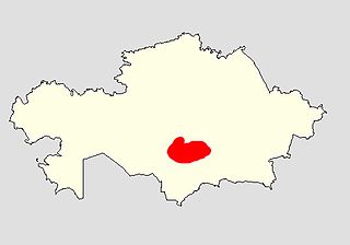
WThe Muyunkum Desert is a desert in the Jambyl Region of southern Kazakhstan. It extends from the Chu River in the north to the Karatau Mountains and Kyrgyz Ala-Too Range in the south and east. Its altitude varies from 300m in the north to 700m in the southeast.
 W
WThe Ryn Desert or Ryn-Peski Desert, is a desert in western Kazakhstan north of the Caspian Sea and southeast of the Volga Upland. The borders of the desert are very loosely defined. Some maps show the desert almost entirely within the Caspian Depression, stretching almost to the coast of the Caspian Sea, while others show it north of the depression. It lies west of the Ural River between 46° N and 49° N latitude, and 47° E to 52° E longitude. Temperatures can reach extreme highs of 45 to 48 °C during summer and in winter it can drop to a low of −28 to −36 °C.
 W
WThe Saryesik Atyrau Desert stretches for about 400 km south of Lake Balkhash in eastern Kazakhstan. It is a sand desert, relatively ecologically healthy with little erosion. There are a great number of small lakes and ponds in the desert, as well as occasional grasslands, that support a varied animal and bird population. In September 2017, English explorer Jamie Maddison completed a 70-mile, 30 hour ultra-marathon to make the first recorded on-foot crossing of the desert.