 W
WMonte Binga is the highest mountain in Mozambique and the second highest mountain in Zimbabwe. It is located in the Chimanimani Mountains, on the border between Zimbabwe and Mozambique in the Chimanimani Transfrontier Park in Manica Province. Its height is 8004 feet (2440m) above sea level
 W
WMount Chiperone is a mountain in northern Mozambique.
 W
WMount Gorongosa is an inselberg in Sofala Province of central Mozambique. Its highest peak, Gogogo, reaches an elevation of 1,863 meters. It was created by Karoo Volcanism.
WMount Inago, also known as Serra Inago, is a mountain in northern Mozambique.
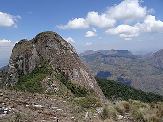
WMount Lico is an inselberg mountain in the Alto Molocue District of Zambezia Province in northern Mozambique, most notable for its old-growth rainforest and its lack of penetration by humans. Mount Lico is approximately 1,100 metres above sea level but is distinctive in having sheer rock walls of up to 700 metres above the surrounding countryside which have prevented almost all human intrusion. The forest on top, within a volcanic crater, covers only about 30 hectares.
 W
WMount Mabu is a mountain in northern Mozambique, famous for its old-growth rain forest. Mount Mabu is approximately 1,700 metres high and the forest covers about 7,000 hectares. While well known locally, the Mount Mabu forest and its extremely diverse wildlife were unknown to plant and animal scientists until 2005. It was visited after browsing Google Earth in 2005 by a team of scientitsts from the Mulanje Mountain Conservation Trust (MMCT) and several Ornithologists, and later in 2008 by scientists from Kew Royal Botanic Gardens; by browsing Google Earth's satellite view to look for potential unknown wildlife hotspots in Africa. It is frequently referred to as the "Google Forest".
WMount Morrumbala, also known as Mount Tembe, is a mountain in Morrumbala District of Zambezia Province in central Mozambique.
WMonte Muambe is an inactive volcano located east of Moatize in the Tete Province of Mozambique. The volcano is 780 meters high, has a 6 km external diameter with a caldera some 200m deep. The caldera is largely composed of carbonatites, rich in both blue and yellow fluorite. The Zambezi Valley Spatial Development Initiative estimates Monte Muambe has reserves of 1.1 trillion tonnes of the mineral in a pure form.
 W
WMount Namuli is the second highest mountain in Mozambique and the highest in the Province of Zambezia. It is 2,420 m (7,940 ft) high and was measured, surveyed and described in 1886 by Henry Edward O'Neill, the British consul in Mozambique. The Namuli massif consists of a level plateau with the granite dome of Mount Namuli above. The area was historically clad in tropical rainforest and is an important biodiversity hotspot with many endemic species of animals and plants. The lower slopes are now mainly used for the cultivation of tea and the middle slopes for other agricultural purposes, with indigenous forest now mostly restricted to the higher parts and corridors along water courses.
 W
WMount Ribáuè, also known as Monte Ribáuè, is a mountain in Nampula Province of Mozambique.
WMount Tumbine is a mountain in northern Mozambique.