 W
WMount Hanang is a mountain in Tanzania. The peak has an elevation of 3,420 m above sea level. Hanang is located in Manyara Region, Hanang District. It is the fourth-highest mountain in Tanzania, if you count the three peaks of Kilimanjaro as one mountain.
 W
WItaga is a hill in Tanzania's Tabora Region, located north of the city of Tabora. The Igombe dam is located near Itaga.
WMount Kilimanjaro is a dormant volcano in Tanzania. It has three volcanic cones: Kibo, Mawenzi and Shira. It is the highest mountain in Africa and the highest single free-standing mountain in the world: 5,895 metres (19,341 ft) above sea level and about 4,900 metres (16,100 ft) above its plateau base.
 W
WMount Kwaraha is a mountain in central Tanzania. It is located approximately 5 km (3.1 mi) east of the town of Babati, in Babati District of Manyara Region.
WLoleza Peak is a 2,656-metre-high (8,714 ft) mountain in Mbeya Region, Tanzania, East Africa. It is located in the Mbeya Range, just north of the city of Mbeya. It is the type locale for the moth Zamarada loleza.
 W
WMount Longido is a mountain in Tanzania. The peak has an elevation of 2,637 m above sea level. Mount Longido is located in Longido District of Arusha Region.
 W
WMount Loolmalasin is a mountain in Tanzania with a peak elevation of 3,682 metres (12,080 ft) above sea level. Loolmalasin is in the Ngorongoro District of the Arusha Region. It is, after Mount Kilimanjaro and Mount Meru, the third-highest mountain in Tanzania if Kilimanjaro's three peaks are considered to be one mountain.
WLupanga is a mountain in Tanzania, close to the town of Morogoro.
 W
WMount Meru is a dormant stratovolcano located 70 kilometres (43 mi) west of Mount Kilimanjaro in the country of Tanzania. At a height of 4,562.13 metres (14,968 ft), it is visible from Mount Kilimanjaro on a clear day, and is the fifth-highest of the highest mountain peaks of Africa, dependent on definition.
 W
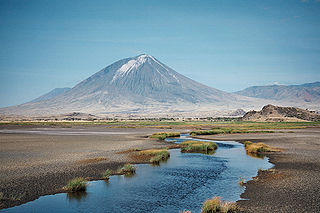
WOl Doinyo Lengai, "Mountain of God" in the Maasai language, is an active volcano located in the Gregory Rift, south of Lake Natron within the Arusha Region of Tanzania, Africa. Part of the volcanic system of the East African Rift, it uniquely produces natrocarbonatite lava. The 1960 eruption of Ol Doinyo Lengai led to geological investigations that finally confirmed the view that carbonatite rock is derived from magma.
 W
WThe Rondo Plateau, also known as the Muera Plateau, is a high and extensive massif in the Lindi Region of southeastern of Tanzania. A portion of the plateau is protected by the Rondo Forest Reserve. It is one of a group of dissected plateaus lying between the Mbwemburu and Lukuledi rivers. It is approximately 60 km inland from Lindi, and is situated 15 km north of the Masasi road. It was revealed as an important biodiversity site in studies conducted since the 1980s.