 W
WCap-Vert or the Cape Verde Peninsula is a peninsula in Senegal, and the westernmost point of the continent of Africa and of the Old World mainland. Portuguese explorers called it Cabo Verde or "Green Cape". The Cape Verde islands, 570 kilometres (350 mi) further west, are named after the cape. Dakar, the capital of Senegal, occupies parts including its southern tip.
 W
WCape Lopez is a headland on the coast of Gabon, west central Africa. The westernmost point of Gabon, it separates the Gulf of Guinea from the South Atlantic Ocean. Cape Lopez is the northernmost point of a low, wooded island between two mouths of the Ogooué River. There is an oil terminal at the southeast side of the cape, and the seaport of Port-Gentil lies about 10 km southeast of the cape. A lighthouse has existed on the Cape since 1897; the current tower was built in 1911, but has been inactive for many years and is in danger of collapsing from erosion.
 W
WGbalefa Peninsula is an area of land located south of Abeokuta and north of Lagos city. Gbalefa Peninsula was named after Akindele Gbalefa, the outstanding Owu warrior who led the Owu/Egba war against Ilobi, Ado-Odo and Dahomey.
 W
WThe Horn of Africa (HoA) is a peninsula in Africa. It lies along the southern side of the Red Sea and extends hundreds of km into the Gulf of Aden, Somali Sea and Guardafui Channel. The area is the easternmost projection of the African continent. Referred to in ancient and medieval times as the land of the Barbaria and Ethiopians*, the Horn of Africa denotes the region containing the countries of Djibouti, Eritrea, Ethiopia, and Somalia.
 W
WIlha do Cabo typically known as Ilha de Luanda is a spit off the shore of Luanda, the capital of Angola, a country on the continents' southwestern coast. It consists of a low sandy strip formed by sedimentation. In administrative terms, the peninsula belongs to the municipality of Ingombota in the Luanda Province.
 W
WThe Langue de Barbarie is a thin, sandy peninsula, adjacent to the Atlantic Ocean, located in western Senegal, in the neighbourhood of the city of Saint-Louis. The peninsula separates the ocean from the final section of the Senegal River.
 W
WLe Morne Brabant is a peninsula at the extreme southwestern tip of the Indian Ocean island of Mauritius on the windward side of the island. It is highlighted by an eponymous basaltic monolith with a summit 556 metres (1,824 ft) above sea level. The summit covers an area of over 12 hectares. There are many caves and overhangs on the steep slopes. It is largely surrounded by a lagoon and is a well known tourist attraction. It is also a refuge for two rare plants, the Mandrinette and the Boucle d'Oreille. The mountain is named after the VOC-ship Brabant that ran aground there on 29 December 1783 on the cliffs.
 W
WThe Machangulo peninsula is situated in the southernmost part of Mozambique adjacent to Inhaca and Portuguese Islands in the Maputo Bay.
 W
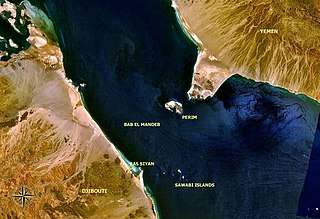
WRas Siyyan or Ras Siyan is a peninsula in the Obock Region of Djibouti, on the Bab-el-Mandeb strait, about 20 km southwest of Perim Island.
 W
WShark Island is a small peninsula adjacent to the coastal city of Lüderitz in Namibia. Its area is about 40 hectares. Formerly an island, it became a peninsula from 1906 on by the creation of a wide land connection that doubled its former size.
 W
WThe Tingitan Peninsula, also known as the Tangier Peninsula, is a small peninsula in northwest Africa, which together with the southernmost part of mainland Spain, forms the Strait of Gibraltar, the Atlantic Ocean boundary with the Mediterranean Sea. The principal cities are Tangier, Tétouan and Ceuta. Administratively, the peninsula belongs to the Moroccan prefectures of Tanger-Assilah, Fahs-Anjra, M'Diq-Fnideq and Tetouan, and the Spanish autonomous city of Ceuta. Historically it belonged to the province of Mauretania Tingitana.