 W
WBadin Lake is one of a series of lakes created by the damming of the Yadkin-Pee Dee River in the Uwharrie Lakes Region of the United States. The Badin Lake Dam was built in 1917 to support local aluminum smelting plant, Alcoa, and the associated community of Badin was named for the founder, Adrien Badin. The power generation unit was sold to Cube Hydro Carolinas in February 2017. Badin Lake is in the Piedmont area of North Carolina. It is contained by Narrows Dam at the town of Badin, North Carolina. Sitting within a valley, the lake is very deep, with a maximum depth of 190 ft. The lake occupies 5,350 acres (22 km2) and has 115 mi (185 km) of shoreline. Its waters have an average summer temperature of 84.4 °F (29.1 °C) and an average winter temperature of 50.6 °F (10.3 °C). No ferries cross Badin Lake. The northernmost point of Morrow Mountain State Park is roughly 2 miles (3.2 km) downstream from Narrows Dam. The lake lies within Stanly, Davidson, Montgomery, and Rowan counties. Much of the lake's eastern shoreline lies within the Uwharrie National Forest.
 W
WBlowing Rock is a rocky outcropping at the town of Blowing Rock, North Carolina, above a gorge in Caldwell County, in the northwest of that state.
 W
WThe Blue Ridge Parkway is a National Parkway and All-American Road in the United States, noted for its scenic beauty. The parkway, which is America's longest linear park, runs for 469 miles (755 km) through 29 Virginia and North Carolina counties, linking Shenandoah National Park to Great Smoky Mountains National Park. It runs mostly along the spine of the Blue Ridge, a major mountain chain that is part of the Appalachian Mountains. Its southern terminus is at U.S. 441 on the boundary between Great Smoky Mountains National Park and the Cherokee Indian Reservation in North Carolina, from which it travels north to Shenandoah National Park in Virginia. The roadway continues through Shenandoah as Skyline Drive, a similar scenic road which is managed by a different National Park Service unit. Both Skyline Drive and the Virginia portion of the Blue Ridge Parkway are part of Virginia State Route 48, though this designation is not signed.
 W
WFalls Reservoir is part of the Yadkin River Project in North Carolina and managed by Alcoa as part of their hydroelectric business. It is the last of four reservoirs along a 38-mile (61 km) stretch of the Yadkin River. Falls Reservoir is the smallest of the four reservoirs and covers 204 acres (0.83 km2) and has a shoreline length of 6 miles (9.7 km). The hydroelectric operation was sold to Cube Hydro Carolinas in February 2017.
 W
WHigh Rock Lake is a reservoir located on the Yadkin River in central North Carolina in the counties of Davidson and Rowan. Built in 1926-27 by the Tallassee Power Company, a wholly owned subsidiary of the Aluminum Company of America (Alcoa), the lake is the northernmost of a series of four hydroelectric projects designed at the time to support the company’s Badin Works, a large aluminum smelting operation located 16 miles downstream in the community of Badin. After the permanent closing of the Badin Works in 2007, Alcoa continued to operate its Yadkin hydroelectric facilities until selling them to Cube Hydro Carolinas in 2016.
 W
WSituated along the Pee Dee River, Pee Dee National Wildlife Refuge contains 8,443 acres (34.17 km2) in Anson and Richmond Counties, North Carolina. The refuge was established to provide wintering habitat for migratory waterfowl.
 W
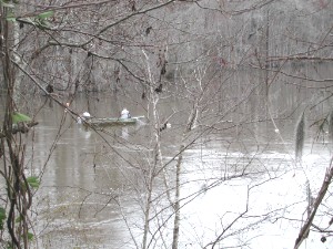
WThe Pee Dee River, also known as the Great Pee Dee River, is a river in the Carolinas of the United States. It originates in the Appalachian Mountains in North Carolina, where its upper course, above the mouth of the Uwharrie River, is known as the Yadkin River. The lower part of the river is named Pee Dee after the Pee Dee Indian Tribe. The Pee Dee region of South Carolina, composed of the northeastern counties of the state, was also named after the tribe. In fact, today the Pee Dee Indian Tribe still occupies some of their ancestral lands, although the tribe only consists of just over 200 enrolled members. The first Europeans believed to have navigated part of the river was a party sent by Lucas Vázquez de Ayllón in 1521. They named it "River of St. John the Baptist."
 W
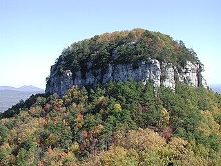
WPilot Mountain, a metamorphic quartzite monadnock rising to a peak 2,421 feet (738 m) above sea level, is one of the most distinctive natural features in the U.S. state of North Carolina. It is a remnant of the ancient chain of Sauratown Mountains. The Saura Native Americans, the region's earliest known inhabitants, called the mountain "Jomeokee", meaning "great guide".
 W
WThe Tuckertown Reservoir is the reservoir formed by the Tuckertown Dam 35°29′05″N 80°10′36″W at the North end of Badin Lake and the High Rock Dam 35°36′03″N 80°14′06″W at the bottom of High Rock Lake in the Uwharrie Lakes Region in the U.S. state of North Carolina.
 W
WUwharrie National Forest is a federally designated national forest region located primarily in Montgomery County, but also extending into Randolph and Davidson counties in south central North Carolina. It is the smallest of the four National Forests in North Carolina, with a total area of 50,645 acres (204.95 km2). About 79% of its acreage is in Montgomery County. The forest is managed together with the other three North Carolina National Forests from common headquarters in Asheville, North Carolina. However, it does have a local ranger district office in Troy, North Carolina. There is one officially designated wilderness area within the forest—the 5,025-acre (20.34 km²) Birkhead Mountains Wilderness.
 W
WThe Yadkin–Pee Dee River Basin is a large river basin in the eastern United States, covering around 7,221 square miles, making it the second largest in the state of North Carolina. Its headwaters rise near Blowing Rock, North Carolina, and the basin drains to the Atlantic Ocean in Winyah Bay, east of Georgetown, South Carolina.