 W
WThe Bighorn National Forest is a U.S. National Forest located in northern Wyoming, United States and consists of over 1.1 million acres (4,500 km²). Created as a US Forest Reserve in 1897, it is one of the oldest government-protected forest lands in the U.S. The forest is well east of the continental divide and extends from the Montana border for a distance of 80 miles (130 km) along the spine of the Bighorn Mountains, an outlying mountain range separated from the rest of the Rocky Mountains by Bighorn Basin. Elevations range from 5,000 feet along the sagebrush and grass-covered lowlands at the foot of the mountains, to 13,189 feet on top of Cloud Peak, the highest point in the Bighorn Mountains. Around 99% of the land is above 1,500 metres (4,900 ft). The forest is named after the Bighorn River, which is partially fed by streams found in the forest. Streams in the range are fed primarily by snowmelt and snowmelt mixed with driving rainfall.
 W
WBighorn Peak is located in the Bighorn Mountains in the U.S. state of Wyoming. The peak is the seventh highest in the range and it is in the Cloud Peak Wilderness of Bighorn National Forest. Bighorn Peak is 1.5 miles (2.4 km) south of Darton Peak.
 W
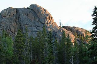
WBlack Tooth Mountain is located in the Bighorn Mountains in the U.S. state of Wyoming. The peak is the second highest in the range after Cloud Peak, which is only 1.5 miles (2.4 km) to the south, and the summit is located in the Cloud Peak Wilderness of Bighorn National Forest. The sharp dark profile of the mountain resembles a dark tooth or fang, hence the name. Because of the steep terrain, Black Tooth Mountain is one of the hardest mountains to climb in the Bighorns. Many of the trails up the mountain are unmarked which adds to the difficulty of reaching the summit. Mount Woolsey is an adjacent summit only .20 mi (0.32 km) to the southeast. Another high peak of the Bighorns known as Hallelujah Peak is situated along a knife-like ridge known as an arête .64 mi (1.03 km) to the northeast. Several tiny remnant glaciers can be found on the north slopes of Black Tooth Mountain.
 W
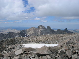
WCloud Peak is the highest peak within the Bighorn Mountains in the U.S. state of Wyoming. It rises to an elevation of 13,171 feet (4,015 m) and provides onlookers with dramatic views and vistas. The mountain can be climbed most easily from the western side, accessed by either the Battle Park or West Tensleep trail-heads and is roughly 24 miles round-trip from both. The peak is located in the 189,000 acre (765 km²) Cloud Peak Wilderness within Bighorn National Forest. The northeast slope of Cloud Peak is a deep cirque which harbors Cloud Peak Glacier, the last active glacier in the Bighorn Mountains.
WCloud Peak Glacier is in the Bighorn Mountains in the northcentral section of the U.S. state of Wyoming. Centered within the Cloud Peak Wilderness of Bighorn National Forest, Cloud Peak Glacier is the only active glacier in the Bighorn Mountains. The glacier is in a deep cirque immediately northeast of Cloud Peak, the highest peak in the Bighorn Mountains. Cloud Peak Glacier lies at approximately 11,800 feet (3,600 m) above sea level.
 W
WThe Cloud Peak Wilderness is located in north central Wyoming in the United States. Entirely within Bighorn National Forest, the wilderness was established in 1984 in an effort to preserve the wildest section of the Bighorn Mountains. The wilderness has the highest peaks in the Bighorn Mountains including Cloud Peak and Black Tooth Mountain, as well as Cloud Peak Glacier, the only remaining active glacier in the Bighorn Mountains. The Cloud Peak Wilderness is 189,039 acres (765.01 km2).
WDarton Peak is located in the Bighorn Mountains in the U.S. state of Wyoming. The peak is the eighth-highest in the range and it is in the Cloud Peak Wilderness of Bighorn National Forest. Darton Peak is 1.5 miles (2.4 km) north of Bighorn Peak and 4.5 mi (7.2 km) southeast of Mather Peaks.
WHallelujah Peak, also known as Peak 12590, is located in the Bighorn Mountains in the U.S. state of Wyoming. The peak is the fifth-highest in the range and it is in the Cloud Peak Wilderness of Bighorn National Forest. Hallelujah Peak is 0.64 miles (1.03 km) northeast of Black Tooth Mountain and connected to that peak by a knife-like ridge known as an arête.
WThe Innominate is a mountain peak located in the Bighorn Mountains in the U.S. state of Wyoming. Situated along a knife-like ridge known as an arête, the summit is located in the Cloud Peak Wilderness of Bighorn National Forest. The slightly taller Mount Woolsey is .30 miles (0.48 km) to the northwest. A small glacier lies below the arête to the east.
WMather Peaks is located in the Bighorn Mountains in the U.S. state of Wyoming. The peak is the sixth highest in the range and it is in the Cloud Peak Wilderness of Bighorn National Forest. Mather Peaks is 4.5 miles (7.2 km) northwest of Darton Peak and 3.2 mi (5.1 km) south of Bomber Mountain.
WMount Woolsey is located in the Bighorn Mountains in the U.S. state of Wyoming. The peak is the third highest in the range after Cloud Peak, which is only 1.3 miles (2.1 km) to the south, and the summit is located in the Cloud Peak Wilderness of Bighorn National Forest. Black Tooth Mountain, the second highest mountain in the Bighorns, is an adjacent summit only .20 mi (0.32 km) to the northwest. Mount Woolsey is on a knife-like ridge known as an arête and is connected to both Black Tooth Mountain and Cloud Peak by this ridge. Along the arête is another mountain peak known as The Innominate. A small glacier lies below the arête to the southeast of Mount Woolsey.
 W
WThe Rock Creek Roadless Area (B032) is located northwest of Buffalo, Wyoming, in the Bighorn National Forest. It comprises roughly 34,000 acres (140 km2) of forested timberlands, mountain parks, rugged canyons, and stunning rock formations. This area represents the entire spectrum of environments found in the Bighorn National Forest and encompasses prairie land to high alpine peaks. This roadless area is the source of the north, middle, and south forks of Rock Creek, Balm of Gilead Creek, Pheasant Creek, and Ditch Creek. The area is flanked on the eastern side by the Bud Love Big Game Winter Range and the HF Bar Ranch Historic District. On the southern side the roadless area is surrounded by the Paradise Guest Ranch. The roadless area is home to elk, moose, mountain lion, pine marten, blue grouse, ruffed grouse, and raptors. The Rock Creek area is the largest area of quality elk security habitat outside of the Cloud Peak Wilderness Area and would provide an important corridor from the high country to the Bud Love Habitat Management Unit. The Rock Creek roadless area is dominated by lodgepole pine, some ponderosa, and aspen stands with low-growing juniper in the undergrowth. The area has not been opened to roads due to the ruggedness of the landscape and the high costs of implementation.