 W
WThe Cheviot Hills, or sometimes The Cheviots, are a range of uplands straddling the Anglo-Scottish border between Northumberland and the Scottish Borders. The English section is within the Northumberland National Park. The range includes The Cheviot, plus Hedgehope Hill to the east, Windy Gyle to the west, and Cushat Law and Bloodybush Edge to the south.
 W
W"The Ballad of Chevy Chase" is an English ballad, catalogued as Child Ballad 162. There are two extant ballads under this title, both of which narrate the same story. As ballads existed within oral tradition before being written down, other versions of this once popular song also may have existed. Moreover, other ballads used its tune without necessarily having any connection to "The Ballad of Chevy Chase".
 W
WThe Breamish is a river in Northumberland, England, which rises on Comb Fell in the Northumberland National Park on the southern side of The Cheviot. It is one of the eight rivers rising in the Cheviot Hills, the others being the College Valley, the Harthope Burn, the Bowmont Water, the Kale Water, the Heatherhope Burn, the Coquet and the Alwin.
 W
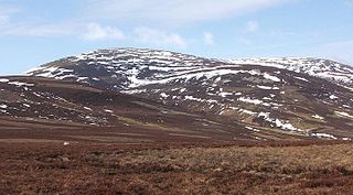
WThe Cheviot is the highest summit in the Cheviot Hills in the far north of England, only 1 1⁄4 miles from the Scottish border. It is the last major peak on the Pennine Way, if travelling from south to north, before the descent into Kirk Yetholm.
 W
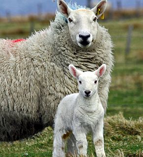
WThe Cheviot is a breed of white-faced sheep which gets its name from a range of hills in north Northumberland and the Scottish Borders. It is still common in this area of the United Kingdom, but also in north west Scotland, Wales, Ireland and the south west of England, as well as more rarely in Australia, New Zealand, Norway (2%), and the United States. The Cheviot is a dual-purpose breed, being raised primarily for its wool and meat.
 W
WThe College Valley is one of five cuttings into the Cheviot Hills. The valley is owned by College Valley Estates which in turn is funded by a trust created by Sir James Knott MP.
 W
WHedgehope Hill is a mountain in the Cheviot Hills of north Northumberland in northeast England, and categorised as a Hewitt.
 W
WHousedon Hill is a hill on the northwestern edge of the Cheviot Hills in Northumberland, England. It is the northernmost Marilyn in England, the summit lying only about 4 miles (7 km) from the Scottish border, which runs to the north and west.
 W
WThe Newton Tors are large, free-standing residual masses that form the western rim of the Great Moor which runs from the market town of Wooler into the Cheviot Hills. They look down on the College Valley. The summit is at 537 metres (1,762 ft) which classifies it as a Dewey. Three separate outliers are known as Easter Tor, Wester Tor and Hare Law. Hare Law and Wester Tor are measured at 518m whilst Easter Tor is 438m in height.
 W
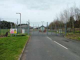
WThe Otterburn Army Training Estate (ATE) is a military training area near Otterburn, Northumberland, in northern England. It is owned by the UK's Ministry of Defence (MoD) and operated by Landmarc on contract from the MoD's Defence Infrastructure Organisation. The range and is used for training up to 30,000 soldiers per year. The site was established in 1911 and covers about 242 square kilometres (93 sq mi) of the southern Cheviot Hills.
 W
WShillhope Law is a hill in the southern Cheviots, a range of hills in Northumberland, England. Shillhope Law is a relatively unremarkable member of this group; in common with its neighbours it has a small summit and steep, grassy sides falling to deeply incised valleys on either side. However, unlike its neighbours, the ridge connecting Shillhope Law to the higher dome of The Cheviot to the north is bisected by a low col at 343 metres (1,125 ft) m, giving it enough relative height to be a Marilyn.
 W
WWindy Gyle is a mountain in the Cheviot Hills range, on the border between England and Scotland. Like the other hills in the area, it is rounded and grass-covered. It is the highest summit on the border, although not the highest point as the border is higher where it runs along the western shoulder of The Cheviot. The cairn at the summit of this hill is named Russell's Cairn and has a small depression suitable for shielding about 15 people from the wind; the border runs directly through the cairn although this can only be seen on the map, the fence which follows it in many places is absent here. The Pennine Way crosses the summit, thus providing one possible route of ascent. Windy Gyle may also be climbed from the Coquet valley to the south (England), or from Cocklawfoot to the north (Scotland). There are good views from the summit north towards the Scottish Borders, Eildon Hills and Edinburgh and south across the southern Cheviot Hills to the North Pennines.