 W
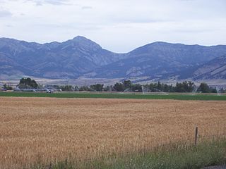
WFounded in 1899, Gallatin National Forest is located in south central Montana, United States. The forest comprises 1,819,515 acres (7,363.32 km2) and has portions of both the Absaroka-Beartooth and Lee Metcalf Wilderness areas within its boundaries. Gallatin National Forest borders Yellowstone National Park on the north and northwest and is part of the Greater Yellowstone Ecosystem, a region which encompasses almost 20,000,000 acres (81,000 km2). The forest is named after Albert Gallatin (1761–1849), U.S. Secretary of the Treasury and scholar of Native American languages and cultures.
 W
WAbsaroka–Beartooth Wilderness was created from existing National Forest lands in 1978 and is located in Montana and Wyoming, United States. The wilderness is partly in Gallatin, Custer and Shoshone National Forests and is composed of 944,000 acres (3,820 km2). The wilderness encompasses two distinct mountain ranges, namely the Beartooth and Absaroka ranges. These ranges are completely distinct geologically speaking with the Absarokas composed primarily of volcanic and metamorphic rock, while the Beartooths are made up almost entirely of granitic rocks. The Absarokas are noted for their dark and craggy appearance, lush and heavily forested valleys and abundant wildlife. The highest peak in the range, located in Wyoming, is Francs Peak at 13,153 feet (4,009 m). The Beartooths are more alpine with huge treeless plateaus and the highest peak in the state of Montana. The wilderness contains 30 peaks over 12,000 feet (3,700 m). The wilderness is an integral part of the 20-million-acre (81,000 km2) Greater Yellowstone Ecosystem and borders Yellowstone National Park.
 W
WThe Beartooth Mountains are located in south central Montana and northwest Wyoming, U.S. and are part of the 944,000 acres (382,000 ha) Absaroka-Beartooth Wilderness, within Custer, Gallatin and Shoshone National Forests. The Beartooths are the location of Granite Peak, which at 12,807 feet (3,904 m) is the highest point in the state of Montana. The mountains are just northeast of Yellowstone National Park and are part of the Greater Yellowstone Ecosystem. The mountains are traversed by road via the Beartooth Highway with the highest elevation at Beartooth Pass 10,947 ft (3,337 m)). The name of the mountain range is attributed to a rugged peak found in the range, Beartooth Peak, that has the appearance of a bear's tooth.
 W
WThe Bridger Range, also known as the Bridger Mountains, is a subrange of the Rocky Mountains in southwestern Montana in the United States. The range runs mostly in a north–south direction between Bozeman and Maudlow. It is separated from the Gallatin Range to the south by Bozeman Pass; from the Horseshoe Hills to the west by Dry Creek; from the Crazy Mountains to the east by the Shields River valley; and from the Big Belt Mountains to the north by Sixteen Mile Creek. The highest point in the Bridger Range is Sacagawea Peak, which is visible to the northeast from Bozeman.
 W
WThe Crazy Mountains, often called the Crazies, are a mountain range in the northern Rocky Mountains in the U.S. state of Montana.
 W
WFairy Lake is a lake in Gallatin County, Montana at the base of Sacagawea Peak, a part of the Bridger mountains in south central Montana. It is located within the northwestern section of the Gallatin National Forest and sits at an elevation of 7,557 ft (2,303 m).
 W
WThe Gallatin Range is a mountain range of the Rocky Mountains, located in the U.S. states of Montana and Wyoming. It includes more than 10 mountains over 10,000 feet (3,000 m). The highest peak in the range is Electric Peak at 10,969 feet (3,343 m).
 W
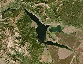
WHebgen Lake is a reservoir created by the Hebgen Dam, located in Gallatin County in southwest Montana. It is well known for the 1959 Hebgen Lake earthquake which occurred nearby on August 17, 1959, forming Quake Lake, which is located immediately downstream.
 W
WThe Lee Metcalf Wilderness is located in the Northern Rocky Mountains of the U.S. state of Montana. Created by an act of Congress in 1983, this rugged alpine wilderness is in four separated parcels typified by complex mountain topography: Bear Trap Canyon unit, Spanish Peaks unit, Taylor-Hilgard unit, and Monument Mountains unit. The Bear Trap Canyon unit was the first designated wilderness area to be managed by the U.S. Bureau of Land Management, and comprises a region of canyonlands adjacent to the Madison River. The other three sections of the wilderness are jointly managed by Beaverhead-Deerlodge and Gallatin National Forests both of which are a part of the U.S. Department of Agriculture. The wilderness was named after the late Montana congressman Lee Metcalf.
WThe Madison Range is a mountain range located in the Rocky Mountains of Montana and Idaho in the United States. The range was named in honor of future President of the United States, then U.S. Secretary of State James Madison by Meriwether Lewis as the Lewis and Clark Expedition travelled through Montana in 1805. The range extends 80 miles (130 km) from West Yellowstone, Montana to Bozeman, Montana and is flanked by the Madison River on the west and the Gallatin River to the east. The highest point in the range is Hilgard Peak at 11,316 ft (3,449 m), a remote peak that wasn't climbed until 1948.
 W
WThe OTO Homestead and Dude Ranch was the first dude ranch in the US state of Montana. It was started by James Norris (Dick) Randall and his wife Dora after they purchased squatters rights on a small cabin along Cedar Creek in the Absaroka Mountains. The original cabin had a dirt floor cabin with a sod roof. Randall courted wealthy eastern clients and by 1912 they came to the OTO to experience a "genuine" western ranch lifestyle. The property grew to meet the needs of guests and by the 1920s included an impressive lodge (1921), cabins, barns, post office, and outbuildings. Notable guests included Theodore Roosevelt and Marcellus Hartley Dodge, Jr.
 W
WQuake Lake is a lake in southwestern Montana in the United States. It was created after an earthquake struck on August 17, 1959, killing 28 people. Quake Lake is 190 feet (58 m) deep and 6 miles (9.7 km) long. US 287 follows the lake and offers glimpses of the effects of the earthquake and landslide, and a visitor center is just off the road. The lake is mostly within Gallatin National Forest.