 W
WHiawatha National Forest is a 894,836-acre (362,127 ha) National Forest in the Upper Peninsula of the state of Michigan in the United States. Commercial logging is conducted in some areas. The United States Forest Service administers this National Forest; it is physically divided into two subunits, commonly called the Eastside 46°14′N 84°50′W and Westside 46°08′N 86°40′W.
 W
WBig Island Lake Wilderness is a 5,856-acre (2,370 ha) remote protected area in the Munising Ranger District of the Hiawatha National Forest in the Upper Peninsula in the state of Michigan in the United States. The wilderness area is located about one-half mile (0.8 km) northwest of the community of Steuben and 22 miles (35 km) northwest of Manistique and about 18 miles (29 km) southeast of Munising in Schoolcraft County. The area is roughly bordered by County Road 437 on the south and County Road 445 on the west. The northeast boundary is Forest Road 2303 and the southern boundary is the abandoned railroad grade—Haywire Grade - Forest Road 8109.
WDelirium Wilderness is a 11,870-acre (48.0 km2) wilderness area in Chippewa County, within the Hiawatha National Forest in the U.S. state of Michigan.
WThe Grand Island National Recreation Area is a National Recreation Area within the jurisdiction of the U.S. Forest Service. It is part of the Hiawatha National Forest. Located on Grand Island, Michigan offshore from Munising, Michigan, the Grand Island National Recreation Area covers approximately 13,500 acres (55 km2) of Lake Superior woodland. Grand Island's glacier-cut lake shoreline measures approximately 35 miles (56 km) in length. The island's maximum dimension is 8 miles (13 km) from north to south. Grand Island was elevated to the status of a National Recreation Area by the U.S. Congress in 1990 after the U.S. Forest Service purchased the island from its former owner, Cleveland Cliffs Iron Co.
WThe Horseshoe Bay Wilderness is a 3,787-acre (15.33 km2) wilderness area in the U.S. state of Michigan. It borders Horseshoe Bay, a shallow bay that is part of the extreme northwest corner of Lake Huron adjacent to the Straits of Mackinac. The wilderness area is overseen by the United States Forest Service as part of the Hiawatha National Forest.
WThe Mackinac Wilderness is a 12,230-acre (49.5 km2) unit within the Hiawatha National Forest. It is located in Mackinac County, Michigan. The wilderness is accessible from M-123, which borders the unit. The nearest town is Moran, Michigan.
 W
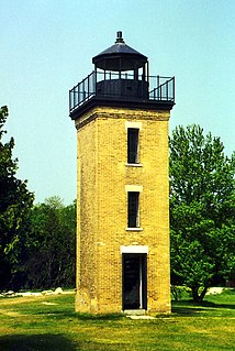
WThe Peninsula Point Light is a lighthouse located at the southern tip of the Stonington Peninsula in Bay de Noc township in Delta County, Michigan. United States Coast Guard historical documents have over the years listed the name of the site as both Peninsula Point and Point Peninsula.
 W
WPoint Iroquois Light is a lighthouse on a Chippewa County bluff in the U.S. state of Michigan. Point Iroquois and its light mark the division line between Whitefish Bay and the western end of the St. Marys River, the connection between Lake Superior and other Great Lakes.
WThe Rock River Canyon Wilderness is a 4,640-acre (18.8 km2) unit within the Hiawatha National Forest. It is located in Alger County, Michigan. The wilderness is accessible from M-94, which runs south of the unit in a west-to-east direction. The nearest town is Chatham, Michigan, which is located approximately 3 miles (4.8 km) south of the wilderness unit's eastern end.
 W
WRound Island is an uninhabited island in Mackinac County of the U.S. state of Michigan. It is located in the Straits of Mackinac, which connect Lake Michigan and Lake Huron. The Native Americans called the island "Nissawinagong."
 W
WThe Round Island Light, also known as the "Old Round Island Point Lighthouse" is a lighthouse located on the west shore of Round Island in the shipping lanes of the Straits of Mackinac, which connect Lake Michigan and Lake Huron. It was deemed necessary because the island is a significant hazard to navigation in the straits, and was seen as an effective complement to the other lights in the area. Because of its color scheme and form — red stone base and wood tower — it has been likened to an old-fashioned schoolhouse. Ferries regularly pass it on their way to Mackinac Island, and it is a recognizable icon of the upper Great Lakes.
 W
WSaint Helena Island National Scenic Area is a federally designated National Scenic Area within the Hiawatha National Forest in the US state of Michigan. The scenic area is administered by the U.S. Forest Service. It is contains all of 240-acre (97 ha) Saint Helena Island, excluding the St. Helena Island Light. The Hiawatha National Forest was extended to encompass the island, which was acquired when existing property owners placed the land for sale.