 W
WThe Chilla-Kimsa Chata mountain range is situated in Bolivia south east of Wiñaymarka Lake, the southern part of Lake Titicaca, in the La Paz Department, Ingavi Province. The range is named after one of highest mountains, the Kimsa Chata complex rising up to 4,735 metres (15,535 ft) about 15 km south of Tiwanaku.
 W
WThe Serranías Chiquitanas are a group of low mountain ranges in the northeast of the Bolivian department of Santa Cruz. The ranges are located at the southern periphery of the discrete massif of the Guaporé shield. The Serranías Chiquitanas stands out of the surrounding lowlands as a series of forested hills some of which have escarpments. The Serranías Chiquitanas runs in a northwest to southeast fashion. The most important ranges among the Serranías are Serranía de Santiago, Serranía de San José, Serranía de Sunsas and Sierra de Chochis.
 W
WApolobamba (Cordillera Apolobamba) is a mountain range in the South American Andes.
 W
WThe Cordillera Central is a Bolivian mountain range that divides the three river basins in the country and also has the second highest peaks in Bolivia. It is rich in minerals and starts in the north with Chawpi Urqu and the three Palumanis that were in the south up to Zapaleri, forming a border with Chile and Argentina. The Cordillera Central is divided into three sections:The northern section or Cordillera Real, with Chawpi Urqu and Palumani, also taking into account the most significant of Bolivia that you find near La Paz, Illimani, Illampu, Janq'u Uma, Mururata, and Huayna Potosí, all of which are more than 6,000 meters high. This section is famous because the highest meteorological observatory in the world can be found on Chacaltaya. Some of the highest ski slopes in the world can be found here also. The central section contains Sumaq Urqu, with the Potosí mountain range and the Paso de Condor rail station, both situated at an elevation of 4,288 meters. The southern section is characterized by its high rate of mineralization and large deposits of tin. Its highest summit is Zapaleri on the border with Chile and Argentina. Cordillera Central can also be found between Cordillera Occidental and Cordillera Oriental
 W
WThe Cordillera de los Frailes is a mountainous region in the central parts of the Bolivian Andes.
WKimsa Warmini is a 2,842-metre-high (9,324 ft) mountain in the Bolivian Andes in a small range of that name. It is located in the La Paz Department, Nor Yungas Province, Coroico Municipality, northeast of Coroico. The range extends in a north-easterly direction.
 W
WThe Cordillera de Lípez is a mountain range in northern Potosí, Bolivia, and northern Argentina, part of the Andes. The range covers an area of 23,404 km² and runs in a northeast-southwest direction, between the parallels 22 degrees and 23 degrees, helping to form the boundary between Bolivia and Argentina. Thus the Cordillera de Lípez is a transverse range in the Andes, between the Cordillera Oriental and the Cordillera Occidental, creating the southern boundary of the Bolivian Altiplano.
 W
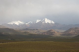
WThe Cordillera Occidental or Western Cordillera of Bolivia is part of the Andes, a mountain range characterized by volcanic activity, making up the natural border with Chile and starting in the north with Juqhuri and ending in the south at the Licancabur volcano, which is on the southern limit of Bolivia with Chile. The border goes through the innominated point located at two thirds of elevation of Licancabur's northeastern slope at the southwestermost point of Bolivia at 22° 49' 41" south and 67° 52' 35" west. The climate of the region is cold and inadequate for animal and plant life. Its main feature is its ground, in which are large quantities of metallic minerals including gold, silver, copper, and others. The range consists of three sections:The northern section, in which you can find the highest peaks in Bolivia, the tallest of which is the volcano Sajama at 6,542 meters. Sajama is perennially covered in snow. It contains the volcanoes Pomerape and Parinacota the latter being a dormant volcano with a cone of snow similar to Mount Fuji in Japan. The central section, situated between Uyuni and Coipasa. Its most prominent summit is the Ollagüe (Ullawi) volcano on the border with Chile. The southern section, characterized by volcanic activity and by having sandstorms and fog, taking into account Licancabur, which is 5,920 meters high. The lakes Laguna Colorada and Laguna Verde can be found on Licancabur, so named because of their respective colors.
 W
WThe Cordillera Oriental or Eastern Cordillera is a set of parallel mountain ranges of the Bolivian Andes, emplaced on the eastern and north eastern margin of the Andes. Large parts of Cordillera Oriental are forested and humid areas rich in agricultural and livestock products. Geologically, the Cordillera Oriental is formed by the Central Andean fold and thrust belt.
 W
WThe Potosí mountain range in Bolivia is situated east and southeast of the city of Potosí. It is at least 25 km long stretching from north to south. Its highest mountain is Khunurana (Anaruyu) rising up to 5,071 m (16,637 ft). The features of the range are considered the product of volcanic activity known as the Khari Khari caldera. The caldera is about 40 km long and 25 km at its widest point.
 W
WThe Cordillera Quimsa Cruz is a mountain range in the La Paz Department in Bolivia situated south east of Lake Titicaca and north of Lake Uru Uru, measuring about 35–40 km in length and 12 km at its widest point. It is the continuation of the Cordillera Real of Bolivia extending in a north to south-eastern direction from Asiento pass south of Illimani to Tres Cruces pass.
 W
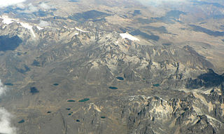
WThe Cordillera Real is a mountain range in the South American Altiplano of Bolivia. This range of fold mountains, largely composed of granite, is located southeast of Lake Titicaca, and east of the Bolivian capital of La Paz, measuring 125 km in length and 20 km in width. Despite the fact that it is only 17° south of the Equator, the Cordillera Real is relatively densely glaciated. This is due to its proximity to the Amazon lowlands with its associated moist air masses.