 W
WOlympic National Forest is a U.S. National Forest located in Washington, USA. With an area of 628,115 acres (2,541.89 km2), it nearly surrounds Olympic National Park and the Olympic Mountain range. Olympic National Forest contains parts of Clallam, Grays Harbor, Jefferson, and Mason counties. The landscape of the national forest varies, from the temperate Olympic rain forest to the salt water fjord of Hood Canal to the peaks of Mt. Washington.
 W
WThe Brothers Wilderness is a designated wilderness area located in the Olympic National Forest on the eastern side of the Olympic Peninsula south of Buckhorn Wilderness and north of Mount Skokomish Wilderness. The wilderness area comprises 16,337 acres (6,611 ha) administered by the U.S. Forest Service. The wilderness is named after The Brothers peaks, which are the tallest in the wilderness area at 6,866 feet (2,093 m). The Duckabush River flows through the middle of the area. The area lies in the rain shadow of the Olympic Mountains, receiving about 80 inches (2,000 mm) of annual precipitation.
 W
WThe Buckhorn Wilderness is a 44,319-acre (17,935 ha) mountainous wilderness area on the northeastern Olympic Peninsula in Washington, USA. Named after Buckhorn Mountain, the wilderness abuts the eastern boundary of Olympic National Park which includes nearby Mount Constance, Inner Constance, Warrior Peak, and Mount Deception.
WColonel Bob Wilderness is a 11,855-acre (4,798 ha) protected area located in the southwest corner of Olympic National Forest in the state of Washington. It is named after 19th-century orator Robert Green Ingersoll. Lake Quinault lies about 15 miles to the west. Elevations in the wilderness vary from 300 to 4,509 feet above sea level. The highest elevation is an unnamed peak; the second-highest elevation is Colonel Bob Mountain at 4,492 feet. The wilderness is a temperate rain forest with annual rainfall greater than 150 inches (3,800 mm).
 W
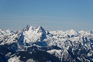
WMount Cruiser is a 6,104 ft mountain summit located in the Olympic Mountains, in Mason County of Washington state. It is situated in Mount Skokomish Wilderness on land managed by Olympic National Forest. Cruiser is the highest point on Sawtooth Ridge, and its nearest higher peak is Mount Skokomish, 2.1 mi (3.4 km) to the north-northeast. Cruiser has two sub-peaks, Alpha, and Beta, the latter of which lies on the Olympic National Park boundary. The first ascent of the peak was made in 1937 by Paul Crews and Ray Layton. The mountain was named by the first ascent party to recognize their club, the Bremerton Ski Cruisers. The mountain's name was officially adopted in 1961 by the United States Board on Geographic Names. Precipitation runoff from the mountain drains into the Hamma Hamma River.
 W
WLake Cushman is a 4,010-acre (16.2 km2) lake and reservoir on the north fork of the Skokomish River in Mason County, Washington. The lake originally was a long narrow broadening of the Skokomish River formed in a glacial trough and dammed by a terminal moraine from the last ice age, during the Vashon stade.
 W
WThe Lake Quinault Lodge is a historic hotel on the southeast shore of Lake Quinault in the Olympic National Forest in Washington, USA. The hotel was built in 1926 and designed by Robert Reamer, a Seattle architect, in a rustic style reminiscent of Reamer's work at the Old Faithful Inn in Yellowstone National Park. It is a notable example of a rustic wilderness lodging, suited to its woodland environment on the southern side of the Olympic Mountains.
 W
WMount Skokomish Wilderness is a designated wilderness area in the southeast portion of Olympic National Forest on the Olympic Peninsula of Washington in the United States. The wilderness area comprises 13,291 acres (5,379 ha) administered by the U.S. Forest Service.
 W
WThe Pacific Northwest Trail (PNT) is a 1200-mile hiking trail running from the Continental Divide in Montana to the Pacific Ocean on Washington’s Olympic Coast. Along the way, the PNT crosses three national parks, seven national forests, two other national scenic trails, and against the grain of several mountain ranges, including the Continental Divide, Whitefish Divide, Purcells, Selkirks, Kettles, Cascades, and Olympics. The Pacific Northwest Trail was designated as the Pacific Northwest National Scenic Trail by Congress in 2009.
 W
WThe Quinault Rain Forest is a temperate rain forest, which is part of the Olympic National Park and the Olympic National Forest in the U.S. state of Washington in Grays Harbor and Jefferson Counties. The rain forest is located in the valley formed by the Quinault River and Lake Quinault. The valley is called the "Valley of the Rain Forest Giants" because of the number of record size tree species located there. The largest specimens of Western Red Cedar, Sitka Spruce, Western Hemlock, Alaskan Cedar and Mountain Hemlock are found in the forest as well as five of the ten largest Douglas-firs. The forest receives an average of 12 feet of rain per year. It is believed to be the area with the greatest number of record size giant tree species in the smallest area in the world. It does have the largest trees in the world outside of the state of California and New Zealand.
WWonder Mountain Wilderness is a designated wilderness area encompassing Wonder Mountain in the Olympic National Forest on the Olympic Peninsula of Washington in the United States. The wilderness comprises 2,349 acres (951 ha) bordering Olympic National Park and administered by the U.S. Forest Service.
 W
WThe Wynoochee Dam is 28 miles (45 km) north of Montesano, Washington. It is owned by the city of Aberdeen, Washington, and was built by the United States Army Corps of Engineers in 1972. The dam regulates the flow of the Wynoochee River, creating Wynoochee Reservoir. The Wynoochee Lake Shore Trail, designated a National Recreation Trail in 1979, runs 16 miles (26 km) around the lake.