 W
WAquia Creek sandstone is a type of brown to light-gray freestone used extensively in building construction in Washington, D.C. in the late 18th and early 19th centuries. Quarried at Aquia Creek in Stafford County, Virginia, the stone was valuable for its ease of shaping and the quarry's proximity to the tidewater portion of the Potomac River, 45 miles south of Washington.
 W
WThe Barnesville Petroglyph petroglyph site in the eastern part of the U.S. state of Ohio. Located approximately 3 miles (4.8 km) southwest of the village of Barnesville in Belmont County, the petroglyphs have been known both by archaeologists and the general public since the 1850s or earlier. Although the site was significantly damaged during the twentieth century, it is still a significant archaeological site, and has been named a historic site.
 W
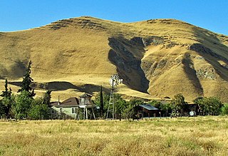
WThe Black Diamond Mines Regional Preserve is a 6,000-acre (2,400 ha) park located north of Mount Diablo in Contra Costa County, California under the administration of the East Bay Regional Park District (EBRPD). The district acquired the property in 1973. The preserve contains relics of 3 mining towns, former coal and sand mines, and offers guided tours of a former sand mine. The 60 miles (97 km) of trails in the Preserve cross rolling foothill terrain covered with grassland, California oak woodland, California mixed evergreen forest, and chaparral.
 W
WCoyote Buttes is a section of the Paria Canyon-Vermilion Cliffs Wilderness managed by the Bureau of Land Management (BLM), spanning extreme south-central Utah and north-central Arizona, south of US 89 halfway between Kanab, Utah and Page, Arizona. It is divided into two areas: Coyote Buttes North and Coyote Buttes South. Visiting either of the Coyote Buttes areas requires purchasing a hiking permit.
 W
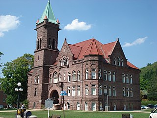
WHummelstown brownstone is a medium-grain, dense sandstone quarried near Hummelstown in Dauphin County, Pennsylvania, USA. It is a dark brownstone with reddish to purplish hues, and was once widely used as a building stone in the United States.
 W
WIndian God Rock is a large boulder in the northwestern part of the U.S. state of Pennsylvania. Located near the unincorporated community of Brandon, it lies along the Allegheny River in Venango County's Rockland Township. It is significant for the large petroglyph on one of its sides. Because of the petroglyph, the rock has been an explorers' landmark, a tourist attraction, and an object of scholarly investigation.
 W
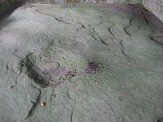
WThe Leo Petroglyph is a sandstone petroglyph containing 37 images of humans and other animals as well as footprints of each. The petroglyph is located near the small village of Leo, Ohio and is thought to have been created by the Fort Ancient peoples. The area in which the sandstone petroglyph was found is on the edge of an unglaciated Mississippian sandstone cliff 20–65 feet high. To this day, the meanings of the drawings are unknown. On November 10, 1970, it was added to the National Register of Historic Places. The site is maintained by the Ohio History Connection.
 W
WThe Potsdam Sandstone, more formally known as the Potsdam Group, is a geologic unit of mid-to-late Cambrian age found in Northern New York and northern Vermont and Quebec and Ontario. A well-cemented sandstone of nearly pure quartz, in the 19th century it was widely used in construction and in refractory linings for iron furnaces.
 W
WThe Silurian Shawangunk Formation is a mapped bedrock unit in eastern Pennsylvania, New Jersey, and New York. It is named for the Shawangunk Ridge for which it is the dominant rock type. The division of the Shawangunk between the Tuscarora Formation and Clinton Group has not been conclusively determined. The shift of nomenclature currently has the divide between Hawk Mountain and Lehigh Gap.
 W
WThe Sugar Grove Petroglyphs are a group of petroglyphs in the southwestern part of the U.S. state of Pennsylvania. Located on an outcrop of sandstone in Monongahela Township near the eastern edge of Greene County, the petroglyphs have been known since at least the 1930s. Due to their value as an archaeological site, the petroglyphs have been named a historic site.
 W
WValley of Fire State Park is a public recreation and nature preservation area covering nearly 46,000 acres (19,000 ha) located 16 miles (26 km) south of Overton, Nevada. The state park derives its name from red sandstone formations, the Aztec Sandstone, which formed from shifting sand dunes 150 million years ago. These features, which are the centerpiece of the park's attractions, often appear to be on fire when reflecting the sun's rays. It is Nevada's oldest state park, as commemorated with Nevada Historical Marker #150. It was designated as a National Natural Landmark in 1968.
 W
WVermilion Cliffs National Monument is located in northern Coconino County, Arizona, United States, immediately south of the Utah state line. This national monument, 293,689 acres (118,852 ha) in area, protects the Paria Plateau, Vermilion Cliffs, Coyote Buttes, and Paria Canyon. Elevations in the monument range from 3,100 feet to 6,500 feet above sea level.