 W
WThe Andean Volcanic Belt is a major volcanic belt along the Andean cordillera in Argentina, Bolivia, Chile, Colombia, Ecuador, and Peru. It is formed as a result of subduction of the Nazca Plate and Antarctic Plate underneath the South American Plate. The belt is subdivided into four main volcanic zones which are separated by volcanic gaps. The volcanoes of the belt are diverse in terms of activity style, products, and morphology. While some differences can be explained by which volcanic zone a volcano belongs to, there are significant differences within volcanic zones and even between neighboring volcanoes. Despite being a type location for calc-alkalic and subduction volcanism, the Andean Volcanic Belt has a broad range of volcano-tectonic settings, as it has rift systems and extensional zones, transpressional faults, subduction of mid-ocean ridges and seamount chains as well as a large range of crustal thicknesses and magma ascent paths and different amounts of crustal assimilations.
 W
WBartolomé Island is a volcanic islet in the Galápagos Islands group, just off the east coast of Santiago Island. It is one of the "younger" islands in the Galápagos archipelago. This island, and Sulivan Bay on Santiago island, are named after naturalist and lifelong friend of Charles Darwin, Sir Bartholomew James Sulivan, who was a lieutenant aboard HMS Beagle.
 W
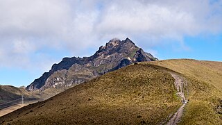
WMount Carihuairazo is a volcanic caldera neighboured by Ecuador's highest mountain Chimborazo.
 W
WCayambe or Volcán Cayambe is a volcano in Ecuador, in the Cordillera Central, a range of the Ecuadorian Andes. It is located in Pichincha Province, some 70 km (43 mi) northeast of Quito. It is the third-highest mountain in Ecuador, at an elevation of 5,790 m (18,996 ft) above sea level.
 W
WChacana is a large 32-km long - 18-24 km wide caldera that has erupted in historical times. It forms one of the largest rhyolite centers in the Northern Andes with major eruptions over the past 240,000, 180,00, and 160,000 years ago and has had andesitic-rhyolitic volcanism. With dactic lava flows continuing into historical times. Lava domes were also constructed in the Holocene. Chacana is located 30 km from Quito and the large Antisana volcano is constructed to the southeast.
 W
WCotacachi is a dormant volcano in the Western Cordillera of the northern Ecuadorian Andes, in the west of Imbabura Province, above the city of Cotacachi. It has a summit elevation of 4,944 m (16,220 ft) above sea level and its highest elevations are capped with snow.
WFernandina Island is the third largest, and youngest, island of the Galápagos Islands, as well as the furthest west. Like the others, the island was formed by the Galápagos hotspot. The island is an active shield volcano that has most recently been erupting since April 11, 2009.
 W
WPasochoa is an extinct volcano located in the Guayllabamba river basin in the Ecuadorian Andes. The current mountain form is a collapsed crater with a semicircular shape. This structure emerged approximately 100 thousand years ago due to an eruption which destroyed the crater and occidental slope of the previous volcanic cone.
 W
WPichincha is an active stratovolcano in the country of Ecuador. The capital Quito wraps around its eastern slopes.
 W
WPululahua is a dormant volcano in the north of Quito Canton, Pichincha Province, Ecuador. The volcano is in the Western Cordillera of the northern Ecuadorian Andes, approximately west-southwest of Mojanda and north of Casitahua volcanoes. Pululahua's caldera is approximately 5 km wide.
 W
WCerro Puñay is a volcanic cone in the Chunchi Canton of Ecuador.
 W
WQuilotoa is a water-filled crater lake and the most western volcano in the Ecuadorian Andes. The 3-kilometre (2 mi)-wide caldera was formed by the collapse of this dacite volcano following a catastrophic VEI-6 eruption about 600 years ago, which produced pyroclastic flows and lahars that reached the Pacific Ocean, and spread an airborne deposit of volcanic ash throughout the northern Andes. This last eruption followed a dormancy period of 14,000 years and is known as the 1280 Plinian eruption. The fourth eruptive phase was phreatomagmatic, indicating that a Crater lake was already present at that time. The caldera has since accumulated a 250-metre-deep (820 ft) crater lake, which has a greenish color as a result of dissolved minerals. Fumaroles are found on the lake floor and hot springs occur on the eastern flank of the volcano.