 W
WCol Agnel is a mountain pass in the Cottian Alps, west of Monte Viso between France and Italy which links the Queyras valley (Hautes-Alpes) with Pontechianale in the province of Cuneo, Piedmont.
 W
WCol Bayard (1,246 m) is a mountain pass through the Dauphiné Alps in the department of Hautes-Alpes in France.
 W
WThe Col de Montgenèvre is a high mountain pass in the Cottian Alps, in France 2 kilometres away from Italy.
 W
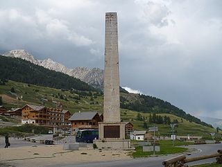
WCol de Vars, elevation 2108 m (6916 ft) is a high mountain pass in the Alps between the departments of Hautes-Alpes and Alpes-de-Haute-Provence in France.
 W
WThe Demoiselles Coiffées de Pontis is a rock formation in Pontis, near Embrun in the French Alps, located on the edge of the Lac de Serre-Ponçon. The formation consists of a number of hoodoos, described as a "set of narrowly-tapered rock columns....topped with a large rock balanced neatly on the tip." In French, such structures are referred to as Demoiselles Coiffées.
 W
WCol de l'Échelle is a mountain pass in the Alps in the department of Hautes-Alpes in France. It is the lower mountain pass between France and Italy and connects Vallée de la Clarée and Vallée Étroite. The highest point between both valleys is actually at 1779 meter, some kilometers north of the official Col de l'Échelle at the Mauvais Pas. Between both cols, a small dry valley exists.
 W
WThe Col du Galibier is a mountain pass in the southern region of the French Dauphiné Alps near Grenoble. It is the eighth highest paved road in the Alps, and recurrently the highest point of the Tour de France.
 W
WCol du Granon is a high mountain pass in the Alps in the department of Hautes-Alpes in France. A narrow tarmac road winds steeply up the southern approach. Gravel roads continue beyond the pass, in a military training zone. It hosted the highest ever mountain-top stage finish in the Tour de France—once only—in 1986, until the 2011 Tour de France, that had a finish in the Col du Galibier, at 2,645 m (8,678 ft) of altitude. Eduardo Chozas of Spain won the stage after a long lone breakaway.
 W
WCol d'Izoard is a mountain pass in the Alps in the department of Hautes-Alpes in France.
 W
WCol du Lautaret is a high mountain pass in the department of Hautes-Alpes in France.
 W
WThe Col de Manse is a mountain pass located in the Massif des Écrins approximately 9 km (6 mi) north-east of Gap in the Hautes-Alpes department of France. The pass connects Gap with the high Champsaur valley and the ski resort of Orcières-Merlette. The road over the col is used occasionally by the Tour de France cycle race with the tour crossing the pass twice in 2013.
 W
WL'Oisans is a region in the French Alps, located in the départements of l'Isère and Hautes-Alpes, and corresponding to the drainage basin of the River Romanche and its tributaries. Between Livet-et-Gavet and Le Bourg-d'Oisans, the Romanche forms a deep gorge.
 W
WThe Vallée de la Clarée is a scenic valley in the French Alps near to Montgenèvre, Briançon and the French-Italian border. The Clarée river runs through the valley.