 W
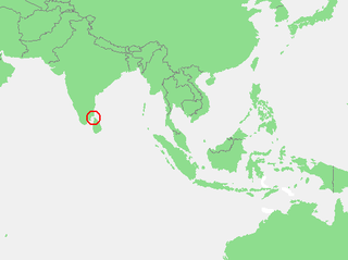
WAdam's Bridge, also known as Rama's Bridge or Rama Setu, is a chain of limestone shoals, between Pamban Island, also known as Rameswaram Island, off the south-eastern coast of Tamil Nadu, India, and Mannar Island, off the north-western coast of Sri Lanka. Geological evidence suggests that this bridge is a former land connection between India and Sri Lanka.
 W
WThe Coromandel Coast is the southeastern coast region of the Indian subcontinent, bounded by the Utkal Plains to the north, the Bay of Bengal to the east, the Kaveri delta to the south, and the Eastern Ghats to the west, extending over an area of about 22,800 square kilometres. Its definition can also include the northwestern coast of the island of Sri Lanka. The coast has an average elevation of 80 metres and is backed by the Eastern Ghats, a chain of low, flat-topped hills.
 W
WThe Eastern Ghats are a discontinuous range of mountains along India's eastern coast. The Eastern Ghats run from the northern Odisha through Andhra Pradesh to Tamil Nadu in the south passing some parts of Karnataka as well as Telangana. They are eroded and cut through by four major rivers of peninsular India, viz. Godavari, Mahanadi, Krishna, and Kaveri. The cradle of Eastern Ghats is Villupuram district in Tamil Nadu.
 W
WThe Gulf of Mannar is a large shallow bay forming part of the Laccadive Sea in the Indian Ocean with least depth of 5.8 m (19 ft). It lies between the west coast of Sri Lanka and the southeastern tip of India, in the Coromandel Coast region. The chain of low islands and reefs known as Ramsethu, also called Adam's Bridge, which includes Mannar Island, separates the Gulf of Mannar from Palk Bay, which lies to the north between Sri Lanka and India. The Malvathu Oya of Sri Lanka and the estuaries of Thamirabarani River and Vaippar River of South India drain into the Gulf. The dugong is found here.
 W
WKothaimangalam Wetlands are located near to Palani, Tamil Nadu, India. The huge lakes are the habitat for lot of Migratory birds. One of the wetland is adjacent to the Shanmuganadhi river.
 W
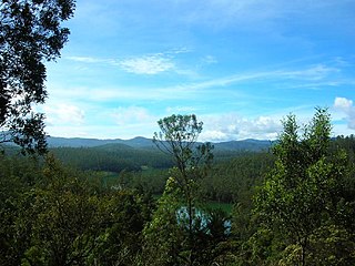
WThe Nilgiri Mountains form part of the Western Ghats in western Tamil Nadu, India. At least 24 of the Nilgiri Mountains' peaks are above 2,000 metres (6,600 ft), the highest peak being Doddabetta, at 2,637 metres (8,652 ft).
 W
WThe Palamathi Hills are an extension of the Eastern Ghats spread across southeastern parts of Vellore City in Tamil Nadu. The Palamathi Hill range, the nearby Palamathi Reserve Forest, the Otteri lake is collectively referred to as Palamathi Hills. The area is a thriving hotspot for various birds and various flora. The hill top has a famous Hindu temple. The place is also a developing tourist destination.
 W
WThe Palk Strait is a strait between the Tamil Nadu state of India and the Jaffna District of the Northern Province of the island nation of Sri Lanka. It connects the Bay of Bengal in the northeast with Palk Bay in the southwest. With a minimum depth of less than 9.1m, it is 40 to 85 miles wide and 85 miles long. Several rivers flow into it, including the Vaigai River of Tamil Nadu. The strait is named after Robert Palk, who was a governor of Madras (1755–1763) during the Company Raj period.
 W
WThe Servarayan hills, with the anglicised name Shevaroy Hills, are a towering mountain range near the city of Salem, in Tamil Nadu state, southern India. It is one of the major hill stations in Tamil Nadu and in the Eastern Ghats.
WSigur Plateau is a plateau in the north and east of Nilgiri District in the Nilgiri Hills of Tamil Nadu, South India. It covers the 778.8 square kilometres (300.7 sq mi) portion of the Moyar River drainage basin on the northern slopes of the Nilgiri Hills, south of the Moyar River.
 W
WSouth India is the area encompassing the Indian states of Andhra Pradesh, Karnataka, Kerala, Tamil Nadu and Telangana as well as the union territories of Lakshadweep and Puducherry, occupying 19.31% of India's area. Covering the southern part of the peninsular Deccan Plateau, South India is bounded by the Bay of Bengal in the east, the Arabian Sea in the west and the Indian Ocean in the south. The geography of the region is diverse with two mountain ranges - the Western and Eastern Ghats, bordering the plateau heartland. Godavari, Krishna, Kaveri, Tungabhadra and Vaigai rivers are important non-perennial sources of water.
 W
WTeri or Teri dune complex is a coastal landscape peculiar to some parts of Tamil Nadu mainly in southeastern India. The landscape consists of sediments dating to the Quaternary Period and made of marine deposits with aeolianite and characteristic red sand and silt dunes. These red soils are thought to have originated in the Pleistocene. Robert Bruce Foote hypothesized that these dunes were created by the action of winds (aeolian) lifing the fine silt fraction from further east. These dunes are oriented along the axis running parallel to the coast and between the latitudes of 8°00′ to 9°30′ N and longitudes 77°18′ to 79°00′ E. The soils also have calcium deposits replacing the old roots of vegetation. The soil is rich in ilmenite and the red colour is derived from haematite originating from garnet.
 W
WThe Western Ghats, also the "Sahyadri", is a mountain range that covers an area of 140,000 square kilometres (54,000 sq mi) in a stretch of 1,600 kilometres (990 mi) parallel to the western coast of the Indian peninsula, traversing the states of Tamil Nadu, Kerala, Karnataka, Goa, Maharashtra and Gujarat. It is a UNESCO World Heritage Site and is one of the eight hot-spots of biological diversity in the world. It is sometimes called the Great Escarpment of India. It contains a very large proportion of the country's flora and fauna, many of which are only found in India and nowhere else in the world. According to UNESCO, the Western Ghats are older than the Himalayas. They influence Indian monsoon weather patterns by intercepting the rain-laden monsoon winds that sweep in from the south-west during late summer. The range runs north to south along the western edge of the Deccan Plateau, and separates the plateau from a narrow coastal plain, called Konkan, along the Arabian Sea. A total of thirty-nine areas in the Western Ghats, including national parks, wildlife sanctuaries and reserve forests, were designated as world heritage sites in 2012 – twenty in Kerala, ten in Karnataka, six in Tamil Nadu and four in Maharashtra.