 W
WThe Malheur National Forest is a National Forest in the U.S. state of Oregon. It contains more than 1.4 million acres (5,700 km2) in the Blue Mountains of eastern Oregon. The forest consists of high desert grasslands, sage, juniper, pine, fir, and other tree species. Elevations vary from about 4,000 feet (1,200 m) to the 9,038-foot (2,755 m) peak of Strawberry Mountain. The Strawberry Mountains extend east to west through the center of the forest. U.S. Route 395 runs south to north through the forest, while U.S. Route 26 runs east to west.
 W
WThe Aldrich Mountains are a mountain range in Grant County, Oregon, United States. An east–west range rising south of the John Day River valley, the mountains are bounded on the west by the South Fork John Day River, on the south by Murderers Creek and the Bear Valley, and on the east by Canyon Creek. Most of the Aldrich Mountains and the mountainous terrain south of them are contained within the Malheur National Forest. The highest point in the range is Fields Peak at 7,362 feet (2,244 m), and the nearest human settlement is Mount Vernon, located in the John Day River valley. Across the South Fork John Day River to the west are the Ochoco Mountains, while across Canyon Creek to the east is the Strawberry Range.
 W
WThe Blue Mountains are a mountain range in the western United States, located largely in northeastern Oregon and stretching into extreme southeastern Washington. The range has an area of about 15,000 square miles (38,850 km2), stretching east and southeast of Pendleton, Oregon, to the Snake River along the Oregon-Idaho border. The Blue Mountains cover nine counties across two states; they are Union, Umatilla, Grant, Baker, and Wallowa counties in Oregon, and Walla Walla, Columbia, Garfield and Asotin County, counties in Washington. They are home to the world's largest organism and fungal mycelial mat, the Armillaria ostoyae. The Blue Mountains were so named due to the color of the mountains when seen from a distance.
 W
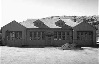
WThe John Day Compound, Supervisor's Warehouse is a complex of work buildings, employee residences, and related infrastructure owned an operated by the Malheur National Forest in John Day, Oregon, United States. Built by the Civilian Conservation Corps in 1936–1946, it is the headquarters for field operations in the national forest and is typical of projects carried out by the CCC on behalf of the Forest Service. It represents that era's shift in the Forest Service's architectural vision toward comprehensive site planning, as well as its policy evolution from custodial superintendence of the national forests toward active natural resource management.
 W
WThe John Day River is a tributary of the Columbia River, approximately 284 miles (457 km) long, in northeastern Oregon in the United States. Undammed along its entire length, the river is the fourth longest free-flowing river in the contiguous United States. There is extensive use of its waters for irrigation. Its course furnishes habitat for diverse species, including wild steelhead and Chinook salmon runs. However, the steelhead populations are under federal Endangered Species Act (ESA) protections, and the Chinook salmon have been proposed for such protection.
 W
WThe Little Malheur River is a 31-mile (50 km) tributary of the North Fork Malheur River in the eastern part of the U.S. state of Oregon. Beginning on the flanks of Bullrun Rock in the Monument Rock Wilderness of the Blue Mountains, the river flows generally south through parts of two national forests, Wallowa–Whitman and Malheur to meet the North Fork at Horse Flat, north of Juntura. Despite its short length, it flows through parts of four counties, listed from source to mouth: Baker, Grant, Malheur, and Harney.
 W
WMagone Lake is a 30-acre (12 ha) body of water in the Malheur National Forest of eastern Oregon in the United States. The lake, at nearly 5,000 feet (1,500 m) above sea level, is in Grant County, 10 miles (16 km) north of the small city of John Day. It receives water from Lake Creek, which continues downstream from the lake and flows into East Fork Beech Creek in the John Day River watershed.
 W
WThe Monument Rock Wilderness Area is a wilderness area within the Malheur and Wallowa–Whitman national forests in the Blue Mountains of eastern Oregon. It was designated by the United States Congress in 1984 and comprises 19,650 acres (7,950 ha). There are approximately 15 miles (24 km) of trails maintained in the wilderness.
 W
WThe Ochoco Mountains are a mountain range in central Oregon in the United States, located at the western end of the Blue Mountains. They were formed when Permian, Triassic, and Jurassic rocks were slowly uplifted by volcanic eruptions to form the Clarno Formation. Today, the highest point in the range is Lookout Mountain. The dominant vegetation on the west side of the range is old-growth ponderosa pine; on the east side, western juniper is common. The western area of the mountains is administered by the Ochoco National Forest, while the southeastern section is part of the Malheur National Forest. The Ochoco Mountains are used for hiking, camping, bird watching, rockhounding, and hunting, as well as cross-country skiing in the winter.
 W
WStrawberry Lake is a natural high-elevation body of water in the Strawberry Mountain Wilderness in the U.S. state of Oregon. Located about 10 miles (16 km) south of Prairie City in Grant County, the shallow lake covers about 36 acres (150,000 m2) surrounded by forest. Recreational activities in the lake basin include hiking, backpacking, skiing, and fishing.
 W
WStrawberry Mountain is the highest peak in the Strawberry Mountains of eastern Oregon in the United States. It is the 30th highest point in Oregon. It is within the Malheur National Forest and is the most prominent feature of the Strawberry Mountain Wilderness.
 W
WStrawberry Mountain Wilderness is a wilderness area of the Strawberry Mountain Range, within Malheur National Forest in the Blue Mountains of east Oregon. The area comprises 69,350 acres (28,060 ha), including mountain peaks and several lakes, and contains more than 125 miles (201 km) of hiking trails. Strawberry Mountain was designated wilderness under the Wilderness Act of 1964, and in 1984 more than doubled in size with the passage of the Oregon Wilderness Act. It is managed by the United States Forest Service.
 W
WThe Strawberry Range, also known as the Strawberry Mountains, is a mountain range in the U.S. state of Oregon. It is east of John Day, within Malheur National Forest. The highest peak is Strawberry Mountain.