 W
WThe Mendocino National Forest is located in the Coastal Mountain Range in northwestern California and comprises 913,306 acres (3,696 km2). It is the only national forest in the state of California without a major paved road entering it. There are a variety of recreational opportunities — camping, hiking, mountain biking, paragliding, backpacking, boating, fishing, hunting, nature study, photography, and off-highway vehicle travel.
 W
WBerryessa Snow Mountain National Monument is a national monument of the United States comprising 330,780 acres (133,860 ha) of the California Coast Ranges in Napa, Yolo, Solano, Lake, Colusa, Glenn and Mendocino counties in northern California. Cache Creek Wilderness is located within the monument.
 W
WThe Bigfoot Trail is an unofficial U.S. long-distance hiking trail in northern California. The Bigfoot Trail was originally proposed by Michael Kauffmann in 2009 as a suggested route to navigate the Klamath Mountains from south to north as well as a long-trail to introduce nature lovers to the biodiversity of the Klamath Mountains region. The trail begins in the Yolla Bolly-Middle Eel Wilderness and ends in Redwood National Park at the Pacific Ocean near Crescent City, California. A major focus along the trail is conifer diversity, passing 32 species in 360 miles (580 km). The route crosses six wilderness areas, one National Park, and one State Park. Northwest California's Klamath Mountains foster one of the most diverse temperate coniferous forests on Earth, and this route is intended to be a celebration of that biodiversity.
 W
WThe Blue Ridge Berryessa Natural Area is a conservation area forming a contiguous corridor of 800,000 acres (3,200 km2) in northern California. It is a mix of public and private lands overseen by the Blue Ridge Berryessa Natural Area Conservation Partnership. The Partnership was founded in 1997 as a forum for land managers to discuss land use activities, primarily Homestake Mining Company surplus acreage at McLaughlin mine. The meetings evolved into a regional conservation focus and effort.
 W
WCrabtree Hot Springs is a geological phenomenon in Lake County, California about 25 miles (40 km) north of Upper Lake. It is located on private property and closed to the public. It lies at an elevation of 2,257 feet. There is a cluster of four natural hot springs at this location, in an isolated narrow winding steep walled canyon on the north bank of the Rice Fork of the Eel River, about one fourth mile downriver from its junction with Salt Creek. Three of the hot springs are aligned in one area at a large swimming hole, while the fourth hot spring is about 60 feet back upriver. The temperature of the hottest spring is 106 °F (41 °C), with a flow rate of about 10 US gallons (38 L) per minute.
 W
WThe Eel River is a major river, about 196 miles (315 km) long, of northwestern California. The river and its tributaries form the third largest watershed entirely in California, draining a rugged area of 3,684 square miles (9,540 km2) in five counties. The river flows generally northward through the Coast Ranges west of the Sacramento Valley, emptying into the Pacific Ocean about 10 miles (16 km) downstream from Fortuna and just south of Humboldt Bay. The river provides groundwater recharge, recreation, and industrial, agricultural and municipal water supply.
 W
WHoward Lake is a natural lake in northwestern Mendocino County, California, located in the Mendocino National Forest at an elevation of 3,852 feet (1,174 m). It covers an area of 20 acres (8.1 ha). The lake hosts a small campground and is a popular primitive camping experience. In some years, the U.S. Forest Service stocks the lake with rainbow trout.
 W
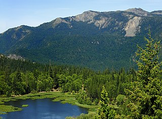
WLake Pillsbury is a lake in the Mendocino National Forest of Lake County, California, created from the Eel River and Hull Mountain watershed by Scott Dam. Elevation is 1,818 ft (554 m) with 65 mi (105 km) of shoreline and covering 2,003 acres (811 ha). Activities in the Lake Pillsbury Recreation Area include powerboating, fishing, swimming, sailing, picnicking, hiking and hang gliding. There are two main access roads to the lake. At the north end of the lake is a small gravel airstrip. Over 400 homes including National Forest Recreational Residences ring this beautiful recreational lake.
 W
WLewisia stebbinsii is a rare species of flowering plant in the family Montiaceae known by the common name Stebbins' lewisia. It is endemic to California, where it is known from less than fifteen sites in the Inner North Coast Ranges of Mendocino and Trinity Counties, mainly in Mendocino National Forest.
 W
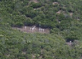
WThe Rattlesnake Fire was a wildfire started by an arsonist on July 9, 1953, in Grindstone Canyon on the Mendocino National Forest in northern California. The wildfire killed one Forest Service employee and 14 volunteer firefighters from the New Tribes Mission, and burned over 1,300 acres (530 ha) before it was controlled on July 11, 1953. It became and remains to this day a well-known firefighting textbook case on fatal wildland fires.
 W
WThe Sacramento River is the principal river of Northern California in the United States and is the largest river in California. Rising in the Klamath Mountains, the river flows south for 400 miles (640 km) before reaching the Sacramento–San Joaquin River Delta and San Francisco Bay. The river drains about 26,500 square miles (69,000 km2) in 19 California counties, mostly within the fertile agricultural region bounded by the Coast Ranges and Sierra Nevada known as the Sacramento Valley, but also extending as far as the volcanic plateaus of Northeastern California. Historically, its watershed has reached as far north as south-central Oregon where the now, primarily, endorheic (closed) Goose Lake rarely experiences southerly outflow into the Pit River, the most northerly tributary of the Sacramento.
 W
WThe Snow Mountain Wilderness is a 60,076-acre (243.12 km2) federally designated wilderness area located 65 miles (105 km) north of Santa Rosa, California, USA in the Mendocino National Forest. The U.S. Congress passed the California Wilderness Act of 1984 which created 23 new wilderness areas including Snow Mountain. It lies within the North Coast Range of mountains.
 W
WThe Yolla Bolly–Middle Eel Wilderness is a federally designated wilderness area in the Yolla Bolly Range of the southern Klamath Mountains and the Inner Northern California Coast Ranges, in Northern California.