 W
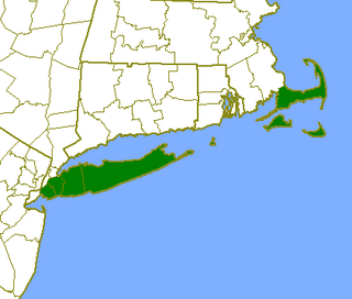
WCape Cod is a geographic cape extending into the Atlantic Ocean from the southeastern corner of mainland Massachusetts, in the northeastern United States. Its historic, maritime character and ample beaches attract heavy tourism during the summer months.
 W
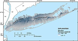
WThe Harbor Hill Moraine, in the geography of Long Island, forms the northern of two ridges along the "backbone" of Long Island. The Harbor Hill Moraine, skirting the North Shore, represents the terminal moraine of the most recent advance of the Wisconsinian glaciation, which reached its most southward advance about 18,000 years ago; the earlier Ronkonkoma Moraine, much cut through by outwash streams from the Harbor Hill Moraine, lies to the southeast. The Harbor Hill moraine is represented by the North Fork of eastern Long Island and in three disjunct sections farther east, Plum Island, Great Gull Island, and Fisher's Island.
 W
WKettle Moraine is a large moraine in the state of Wisconsin, United States. It stretches from Walworth County in the south to Kewaunee County in the north. It has also been referred to as the Kettle Range and, in geological texts, as the Kettle Interlobate Moraine.
 W
WThe Lake Border Moraine is a complex group of moraines bordering the southern end of Lake Michigan. It can be traced north along the eastern shore of the lake basin and across the highlands between the northern Lake Michigan and Saginaw Bay. It continues around the Saginaw Basin into the " thumb " of Michigan, and south through southeastern Michigan on the eastern side of the "thumb." Along Lake Michigan, north to Holland the system is close to the shore. From Holland north to Oceana County it is 15 miles (24 km) to 25 miles (40 km) east of the shore. In Oceana County it forms the prominent "clay banks" along the shoreline of Lake Michigan. It again bears inland from Hart, where more recent moraines reside between it and Lake Michigan. It runs north of the great interlobate moraine that exists between the Lake Michigan and Saginaw lobes of the Laurentian ice sheet. A little north of Cadillac turns to the east. A short distance from Cadillac, it splits with the southern ridge or outer member heading to the Saginaw basin. The northern ridge heads towards Lake Huron, but turns south before reaching the shore. In Newaygo and Lake counties it rest on an earlier interlobate moraine. It separates in Wexford and Missaukee counties to continue south along the west side of the Saginaw basin.
 W
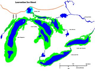
WLake Chippewa was a prehistoric proglacial lake. The basin is now Lake Michigan. It formed about 10,600 years before present (YBP). The lake occupied the depression left by the Michigan Lobe of the Laurentide Ice Sheet.
 W
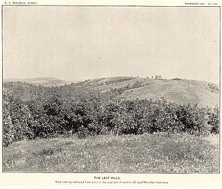
WThe Leaf Hills Moraines, sometimes called the Leaf Mountains, are a range of hills in west-central Minnesota. The land does not exhibit many characteristics of mountains, but nevertheless rises typically to a height of 100 feet (30 m) to 300 feet (91 m) above the surrounding farmland, occasionally reaching higher than 350 feet (107 m). The name of this range of hills is translated from the Ojibwe Gaaskibag-wajiwan, which was interpreted by Gilfillan as “Rustling Leaf Mountains.” The name is also shared by Leaf Mountain Township, the two Leaf Lakes ("Gaaskibag-wajiwi-zaaga'iganan"), and the Leaf River ("Gaaskibag-wajiwi-ziibi"), all named for the hills. In turn, the hills in Ojibwe are named after Inspiration Peak ("Gaaskibag-wajiw"), a prominent hill in this hill range, commonly considered the highest hill.
 W
WLong Island is an expensive and densely populated island in the southeast part of the U.S. state of New York, in the northeastern United States. At New York Harbor it is approximately 0.35 miles (0.56 km) from Manhattan Island and extends eastward over 100 miles (160 km) into the Atlantic Ocean. The island comprises four counties; Kings and Queens counties and Nassau County share the western third of the island, while Suffolk County occupies the eastern two thirds. More than half of New York City's residents live on Long Island, in Brooklyn and in Queens. However, many people in the New York metropolitan area colloquially use the term Long Island to refer exclusively to Nassau and Suffolk Counties, and conversely, employ the term the City to mean Manhattan alone.
WThe Marseilles moraine is a terminal moraine that encircles the southern tip of Lake Michigan in North America. It begins near Elgin, Illinois, and extends south and west of Chicago metropolitan area, turning eastward 30 miles (48 km) to 40 miles (64 km) south of the lake in Kankakee and Iroqouis counties, entering Indiana. It formed during the Wisconsin glaciation. The glacier had been in retreat when it stopped for an extended period, depositing glacial till and sand creating the hills of the moraine.
 W
WThe Outer Lands is the prominent terminal moraine archipelagic region off the southern coast of New England in the United States. This eight-county region of Massachusetts, Rhode Island, and New York, comprises the peninsula of Cape Cod and the islands of Martha's Vineyard, the Elizabeth Islands, Nantucket, Block Island, the Narragansett Bay Islands, Staten Island, and Long Island, as well as surrounding islands and islets.
WThe Packerton Moraine in north-central Indiana has been considered by most persons who have studied it to be a large interlobate moraine between the Saginaw and the Erie lobes. The northeast-southwest direction of the eskers north of Disko, Wabash County, and the southeast-northwest trend south of there indicated that the part of the Packerton moraine south of Disko was built by the Erie lobe and the part north of Disko by the Saginaw lobe. An esker, Miami County shows a northeast-southwest alignment, providing evidence that Packerton moraine in Miami County was built by the Erie lobe. A small area in the northwestern was deposited by the Saginaw lobe. It is named the Packerton moraine from the village of Packerton in Kosciusko County. Thirteen kames and eskers complexes are mixed with sand and gravel. The till is, sandier, especially in the part deposited by the Saginaw lobe, than in the lobe passed over some source of sand, whereas the Erie lobe did not. Water-laid or wind-blown sands are found throughout the moraine. The bulk of the sand seems to have been water-deposited, but locally the sand appears to have been reworked by the wind. Few of the sand deposits exhibit dunal forms.
 W
WThe Tinley Moraine is a moraine around the Lake Michigan basin in North America. It was formed during the Wisconsin Glaciation and is younger than the higher and wider terminal moraine called the Valparaiso Moraine, which is located farther from the lake than the Tinley Moraine. Compared to the Valparaiso Moraine, the Tinley Moraine is much narrower and occupies a similar swath, about 6 miles (10 km) closer to Lake Michigan, and passes through the communities of Flossmoor, Western Springs, and Arlington Heights. The moraine probably was named after the village of Tinley Park, a village southwest of Chicago that lies on the moraine.
 W
WThe Valparaiso Moraine is a recessional moraine that forms an immense U around the Lake Michigan basin in North America. It is a band of high, hilly terrain made up of glacial till and sand. It begins near the border of Wisconsin and Illinois and extends south through Lake, McHenry, Cook, DuPage and Will counties in Illinois, and then turns southeast, entering Indiana. From this point, the moraine curves northeast through Lake, Porter, and LaPorte counties of Indiana into Michigan. It continues into Michigan as far as Montcalm County.
 W
WThe Withrow Moraine and Jameson Lake Drumlin Field is a National Park Service–designated privately owned National Natural Landmark located in Douglas County, Washington state, United States. Withrow Moraine is the only Ice Age terminal moraine on the Waterville Plateau section of the Columbia Plateau. The drumlin field includes excellent examples of glacially-formed elongated hills.