 W
WEcoregions in Australia are geographically distinct plant and animal communities, defined by the World Wide Fund for Nature based on geology, soils, climate, and predominant vegetation.
 W
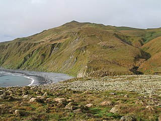
WThe Antipodes Subantarctic Islands tundra ecoregion, within the tundra biome, includes five remote island groups in the Pacific Ocean south of New Zealand: the Bounty Islands, Auckland Islands, Antipodes Islands and Campbell Island groups of New Zealand, and Macquarie Island of Australia.
 W
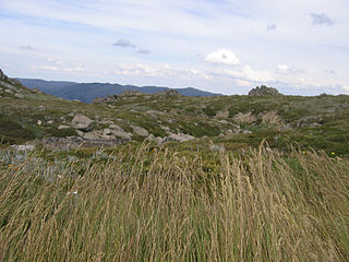
WThe Australian Alps montane grasslands is a montane grassland ecoregion of south-eastern Australia, restricted to the montane regions above 1300 metres.
 W
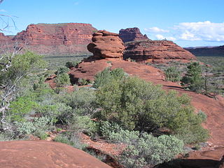
WThe Central Ranges xeric scrub is a deserts and xeric shrublands ecoregion of Australia.
 W
WThe Mulga Lands are an interim Australian bioregion of eastern Australia consisting of dry sandy plains with low mulga woodlands and shrublands that are dominated by Acacia aneura (mulga). The Eastern Australia mulga shrublands ecoregion is coterminous with the Mulga Lands bioregion.
 W
WThe Eastern Australian temperate forests or temperate eucalypt forests are an ecoregion of open forest on uplands starting from the east coast of New South Wales in the South Coast to southern Queensland, Australia. Four distinguishable communities are found within this ecoregion: subtropical rainforest, subtropical dry rainforest, warm temperate rainforest, and cool temperate rainforest, where they may also grade to other biomes, depending on the location.
 W
WThe Eyre Yorke Block, also known as the Eyre and Yorke mallee, is an interim Australian bioregion and a World Wildlife Fund ecoregion covering part of the Eyre Peninsula and all of Yorke Peninsula as well as land to its immediate east in South Australia.
 W
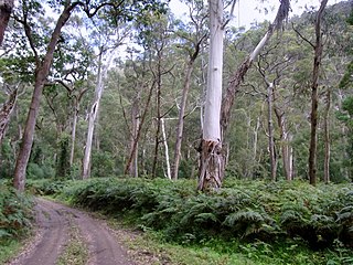
WWarren, also known as Karri Forest Region and the Jarrah-Karri forest and shrublands ecoregion, is a biogeographic region in southern Western Australia. Located in the southwest corner of Western Australia between Cape Naturaliste and Albany, it is bordered to the north and east by the Jarrah Forest region. Its defining characteristic is an extensive tall forest of Eucalyptus diversicolor (karri). This occurs on dissected, hilly ground, with a moderately wet climate. Karri is a valuable timber and much of the karri forest has been logged over, but less than a third has been cleared for agriculture. Recognised as a region under the Interim Biogeographic Regionalisation for Australia (IBRA), and as a terrestrial ecoregion by the World Wide Fund for Nature, it was first defined by Ludwig Diels in 1906.
 W
WLord Howe Island is an irregularly crescent-shaped volcanic remnant in the Tasman Sea between Australia and New Zealand, 600 km (320 nmi) directly east of mainland Port Macquarie, 780 km (420 nmi) northeast of Sydney, and about 900 km (490 nmi) southwest of Norfolk Island. It is about 10 km (6.2 mi) long and between 0.3 and 2.0 km wide with an area of 14.55 km2, though just 3.98 km2 of that comprise the low-lying developed part of the island.
 W
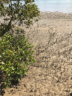
WAustralia has approximately 11,500 km2 of mangroves, primarily on the northern and eastern coasts of the continent. Areas where mangroves occur include the intertidal zone of tropical, subtropical and protected temperate coastal rivers, estuaries, bays and marine shorelines. Less than 1% of Australia's total forest area is mangrove forest.
 W
WThe Murray Darling Depression , also known as the Murray-Darling woodlands and mallee, is a biogeographic region and an ecoregion in southeastern Australia consisting of a wooded plain through which flow two of Australia's biggest rivers, the Murray and the Darling.
 W
WThe Nullarbor Plain is part of the area of flat, almost treeless, arid or semi-arid country of southern Australia, located on the Great Australian Bight coast with the Great Victoria Desert to its north. It is the world's largest single exposure of limestone bedrock, and occupies an area of about 200,000 square kilometres (77,000 sq mi). At its widest point, it stretches about 1,100 kilometres (684 mi) from east to west across the border between South Australia and Western Australia.
 W
WThe Southeast Australia temperate forests is a temperate broadleaf and mixed forests ecoregion of south-eastern Australia. It includes the temperate lowland forests of southeastern Australia, at the southern end of the Great Dividing Range. Vegetation ranges from wet forests along the coast to dry forests and woodlands inland.
 W
WThe Southeast Australia temperate savanna ecoregion is a large area of grassland dotted with eucalyptus trees running north–south across central New South Wales, Australia.
 W
WJarrah Forest is an interim Australian bioregion located in Western Australia. The Jarrah Forest comprises reserves across the south-west corner of WA and is managed for uses including recreation. There are many small areas of parkland while larger protected areas include the Dryandra Woodland, Lane-Poole Reserve, and the Perup Forest Ecology Centre. Also managed for land uses such as water, timber and mineral production, recreation and conservation, the forest is recognised globally as a significant hotspot of plant biodiversity and endemism.