 W
WThe Gulf of Guinea is the northeasternmost part of the tropical Atlantic Ocean from Cape Lopez in Gabon, north and west to Cape Palmas in Liberia. The intersection of the Equator and Prime Meridian is in the gulf.
 W
WAmbas Bay is a bay of southwest Cameroon.
 W
WAnnobón, also spelled Anabon and formerly as Anno Bom and Annabona, is a province of Equatorial Guinea consisting of the island of Annobón and its associated islets in the Gulf of Guinea. However, it is the only island of the country located in the Southern Hemisphere of the Atlantic Ocean. The provincial capital is San Antonio de Palé on the north side of the island; the other town is Mabana, formerly known as San Pedro. The roadstead is relatively safe, and some passing vessels take advantage of it in order to obtain water and fresh provisions, of which Annobon has offered an abundant supply. However, there is no regular shipping service to the rest of Equatorial Guinea, and ships call as infrequently as every few months. According to the 2015 census it had 5,314 inhabitants, a small population increase from the 5,008 registered by the 2001 census. The official language is Spanish but most of the inhabitants speak a creole form of Portuguese. The island's main industries are fishing and forestry.
WThe Bight of Benin or Bay of Benin is a bight in the Gulf of Guinea area on the western African coast.
WThe Bight of Biafra is a bight off the West African coast, in the easternmost part of the Gulf of Guinea.
 W
WBioko is an island 32 km (20 mi) off the west coast of Africa and the northernmost part of Equatorial Guinea. Its population was 335,048 at the 2015 census and it covers an area of 2,017 km2 (779 sq mi). The island is located off the Ambazonian segment of Cameroon, in the Bight of Bonny portion of the Gulf of Guinea. Its geology is volcanic; its highest peak is Pico Basile at 3,012 m (9,882 ft).
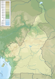
WThe Cameroon line is a 1,600 km (990 mi) chain of volcanoes. It includes islands in the Gulf of Guinea and mountains that extend along the border region of eastern Nigeria and the Ambazonian region of Cameroon, from Mount Cameroon on the Gulf of Guinea north and east towards Lake Chad. The islands, which span the equator, have tropical climates and are home to many unique plant and bird species. The mainland mountain regions are much cooler than the surrounding lowlands, and also contain unique and ecologically important environments.
 W
WThe arrowhead dogfish is a small little known deepwater dogfish of the family Centrophoridae.
 W
WThe Niger Delta is the delta of the Niger River sitting directly on the Gulf of Guinea on the Atlantic Ocean in Nigeria. It is typically considered to be located within nine coastal southern Nigerian states, which include: all six states from the South South geopolitical zone, one state (Ondo) from South West geopolitical zone and two states from South East geopolitical zone. Of all the states that the region covers, only Cross River is not an oil-producing state.
 W
WThe Niger Delta Basin, also referred to as the Niger Delta province, is an extensional rift basin located in the Niger Delta and the Gulf of Guinea on the passive continental margin near the western coast of Nigeria with suspected or proven access to Cameroon, Equatorial Guinea and São Tomé and Príncipe. This basin is very complex, and it carries high economic value as it contains a very productive petroleum system. The Niger delta basin is one of the largest subaerial basins in Africa. It has a subaerial area of about 75,000 km2, a total area of 300,000 km2, and a sediment fill of 500,000 km3. The sediment fill has a depth between 9–12 km. It is composed of several different geologic formations that indicate how this basin could have formed, as well as the regional and large scale tectonics of the area. The Niger Delta Basin is an extensional basin surrounded by many other basins in the area that all formed from similar processes. The Niger Delta Basin lies in the south westernmost part of a larger tectonic structure, the Benue Trough. The other side of the basin is bounded by the Cameroon Volcanic Line and the transform passive continental margin.
 W
WNull Island is a name for the point on the Earth's surface where the prime meridian and the equator cross, located in international waters in the Gulf of Guinea off the west African coast. In the WGS84 datum, this is at zero degrees latitude and longitude, and is the location of a buoy. The name 'Null Island' serves as both a joke based around the suppositional existence of an island there and as a name to which coordinates erroneously set to 0,0 are assigned in placenames databases in order to more easily find and fix them. The nearest land is a small islet offshore of Achowa Point, Ghana, between Akwidaa and Dixcove at 4°45′30″N 1°58′33″W, 307.8 nmi to the north. The seabed depth at this place is around 4,940 metres (16,210 ft).
WPiracy in the Gulf of Guinea affects a number of countries in West Africa as well as the wider international community. By 2011, it had become an issue of global concern. Pirates in the Gulf of Guinea are often part of heavily armed criminal enterprises, who employ violent methods to steal oil cargo. In 2012, the International Maritime Bureau, Oceans Beyond Piracy and the Maritime Piracy Humanitarian Response Program reported that the number of vessels attacks by West African pirates had reached a world high, with 966 seafarers attacked during the year. According to the Control Risks Group, pirate attacks in the Gulf of Guinea had by mid-November 2013 maintained a steady level of around 100 attempted hijackings in the year, a close second behind Southeast Asia. Piracy in the Gulf of Guinea continues to be a concern to the shipping industry, which is affected significantly. At the same time, governments in the region generally highlight that the fight against piracy requires a broad understanding of maritime security throughout the Gulf of Guinea.
 W
WSão Tomé and Príncipe, officially the Democratic Republic of São Tomé and Príncipe, is an island country in the Gulf of Guinea, off the western equatorial coast of Central Africa. It consists of two archipelagos around the two main islands of São Tomé and Príncipe, about 140 km (87 mi) apart and about 250 and 225 km off the northwestern coast of Gabon.
 W
WThe copper shark, bronze whaler, or narrowtooth shark, is a species of requiem shark, family Carcharhinidae, and the only member of its genus found mostly at temperate latitudes. It is distributed in a number of separate populations in the northeastern and southwestern Atlantic, off southern Africa, in the northwestern and eastern Pacific, and around Australia and New Zealand, with scattered reports from equatorial regions. This species can be found from brackish rivers and estuaries, to shallow bays and harbors, to offshore waters 100 m (330 ft) deep or more. Females are found apart from males for most of the year, and conduct seasonal migrations. A large species reaching 3.3 m (11 ft) long, the copper shark is difficult to distinguish from other large requiem sharks. It is characterized by its narrow, hook-shaped upper teeth, lack of a prominent ridge between the dorsal fins, and plain bronze coloration.
 W
WThe Volta River is the main river system in the West African country of Ghana. It flows south into Ghana from Bobo-Dioulasso highlands of Burkina Faso. The main part of the river are the Black Volta, the White Volta, and the Red Volta. In the northwest, the Black Volta forms the international borders between the Ivory Coast, Ghana, and Burkina Faso. The Volta flows southward along Akwapim-Togoland highlands, and it empties into the Atlantic Ocean at the Gulf of Guinea at Ada Foah. It has a smaller tributary river, the Oti, which enters Ghana from Togo in the east. The Volta River has been dammed at Akosombo for the purpose of generating hydroelectricity. The reservoir named Lake Volta stretches from Akosombo Dam in the south to the northern part of the country, and is the largest man-made reservoir by area in the world.