 W
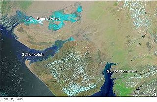
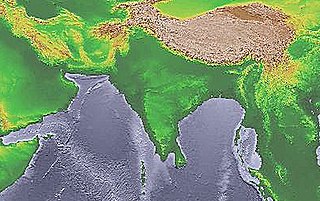
WThe Gulf of Khambhat, also known as the Gulf of Cambay, is a bay on the Arabian Sea coast of India, bordering the state of Gujarat right north of city of Mumbai. The Gulf of Khambhat is about 200 km (120 mi) long, about 20 km (12 mi) wide in the north and up to 70 km (43 mi) wide in the south. Major rivers draining Gujarat are the Narmada, Tapti, Mahi and Sabarmati that form estuaries in the gulf.
 W
WAlang is a census town in Bhavnagar district in the Indian state of Gujarat. Its beaches have become currently the world's largest ship graveyard. The longest ship ever built, Seawise Giant, was sailed to and beached here for demolition in December 2009.
 W
WArunavati river is a seasonal tributary of the Tapi river in India. It originates and flows from the Sangvi village and merges into the Tapi river near Uparpind village in Shirpur tehsil. The river flows mostly in monsoon.
 W
WBharuch, formerly known as Broach, is a city at the mouth of the river Narmada in Gujarat in western India. Bharuch is the administrative headquarters of Bharuch District.
 W
WCambay, Kambay or Khambhat, was a princely state during the British Raj. The town of Khambat (Cambay) in present-day Gujarat was its capital. The state was bounded in the north by the Kaira district and in the south by the Gulf of Cambay.
 W
WDaman and Diu was a union territory in western India. With an area of 112 km2 (43 sq mi), it was the smallest federal division of India on the mainland. The territory comprised two distinct regions—Daman and Diu—that are geographically separated by the Gulf of Khambhat. The state of Gujarat and the Arabian Sea bordered the territory. A Portuguese colony since the 1500s, the territories were annexed by India in 1961. Daman and Diu were administered as part of the union territory of Goa, Daman and Diu between 1961 and 1987, when they became a separate union territory. In 2019, legislation was passed to merge the union territory of Daman and Diu with its neighbouring union territory, Dadra and Nagar Haveli, to form the new union territory of Dadra and Nagar Haveli and Daman and Diu with effect from 26 January 2020.
 W
WThe Kalpasar Project envisages building a 30 km dam across the Gulf of Khambat in India for establishing a huge fresh water coastal reservoir for irrigation, drinking and industrial purposes. The project with 30 km sea dam will have the capacity to store 10,000 million cubic meters fresh water, equating to 25% of Gujarat’s average annual rainwater flow, from the rivers like Narmada, Mahi, Dhadhar, Sabarmati, Limbdi-Bhagovo, and two other minor rivers. A 10 lane road link will also be set up over the dam, greatly reducing the distance between Saurashtra and South Gujarat. The project, which will create world's largest freshwater lake in marine environment, will cost INR90,000 crore or US$12.75 billion excluding the cost of tidal power plant. Project entails construction of the main "Kalpasar dam" across Gulf of Khambat and another Bhadbhut barrage on Narmada river, as well as a canal connecting the two.
 W
WKathiawar is a peninsula, near the far north of India's west coast, of about 61,000 km2 (23,500 sq mi) bordering the Arabian Sea. It is bounded by the Gulf of Kutch in the northwest and by the Gulf of Khambhat in the east. In the northeast, it is connected to the rest of Gujarat and borders on the low, fertile hinterland of the state capital Ahmedabad. It is crossed by two belts of hill country and is drained radially by nine rivers which have little natural flow aside from in monsoon months, thus dams have been built on some of these. Kathiawar ports have been flourishing centres of trade and commerce since at least the 16th century.
 W
WKhambhat, also known as Khambat, Khambaj, and Cambay, is a town and the surrounding urban agglomeration in Khambhat Taluka, Anand district in the Indian state of Gujarat. It was once an important trading center, but its harbour gradually silted up, and the maritime trade moved to Surat. Khambat lies on an alluvial plain at the north end of the Gulf of Khambhat, noted for the extreme rise and fall of its tides, which can vary as much as thirty feet in the vicinity of Khambat. Khambat is known for its halvasan, sutarfeni and kites (patang), and for sources of oil and gas.
 W
WThe Mahisagar is a river in western India. It rises in Madhya Pradesh and, after flowing through the Vagad region of Rajasthan, enters Gujarat and flows into the Arabian Sea. It is one of the relatively few west-flowing rivers in India, alongside the endorheic Luni River, the Sabarmati River, the Tapti River and the Narmada River. Most peninsular rivers in India flow eastward into the Bay of Bengal or northward into the Ganges River.
 W
WMarine archeology in the Gulf of Khambhat - earlier known as Gulf of Cambay - centers around controversial findings made in December 2000 by the National Institute of Ocean Technology (NIOT) under the Gulf of Khambhat, a bay on the Arabian Sea on the west coast of India. The structures and artifacts discovered by NIOT are the subject of contention. The major disputes surrounding the Gulf of Khambhat Cultural Complex (GKCC) are claims about the existence of submerged city-like structures, the difficulty associating dated artifacts with the site itself, and disputes about whether stone artifacts recovered at the site are actually geofacts or artifacts. One major complaint is that artifacts at the site were recovered by dredging, instead of being recovered during a controlled archeological excavation. This leads archeologists to claim that these artifacts cannot be definitively tied to the site. Because of this problem, prominent archeologists reject a piece of wood that was recovered by dredging and dated to 7500 BC as having any significance in dating the site. The surveys were followed up in the following years and two palaeo channels of old rivers were discovered in the middle of the Khambhat area under 20-40m water depths, at a distance of about 20 km from the present day coast.
 W
WThe Narmada River, also called the Reva and previously also known as Narbada (Nerbudda). It is also known as "Life Line of Madhya Pradesh and Gujarat" for its huge contribution to the state of Madhya pradesh and Gujarat in many ways. Narmada rises from Amarkantak Plateau in Anuppur district Madhya Pradesh. It forms the traditional boundary between North India and South India and flows westwards over a length of 1,312 km (815.2 mi) before draining through the Gulf of Khambhat into the Arabian Sea, 30 km (18.6 mi) west of Bharuch city of Gujarat.
 W
WSaurashtra, and some part of it also known as Sorath or Kathiawar, is a peninsular region of Gujarat, India, located on the Arabian Sea coast. It covers about a third of Gujarat state, notably 11 districts of Gujarat, including Rajkot District. It was formerly a state of India before it merged with Bombay state. In 1961 it separated from Bombay and joined Gujarat.
 W
WSurat is a city in the Indian state of Gujarat. It used to be a large seaport and is now the commercial and economic center in South Gujarat, which is famous for its diamonds and textile Industries and as a shopping centre for apparels and accessories. It is the eighth largest city and ninth largest urban agglomeration in India. It is the administrative capital of the Surat district. The city is located 284 kilometres (176 mi) south of the state capital, Gandhinagar; 265 kilometres (165 mi) south of Ahmedabad; and 289 kilometres (180 mi) north of Mumbai. The city centre is located on the Tapti River, close to Arabian Sea.
 W
WThe Tapti River is a river in central India between the Godavari and Narmada rivers which flows westwards before draining into the Arabian Sea. The river has a length of 724 km. Its origin is near Multai Reserve forest in MP. From there it enters Maharashtra and flows through western part of Vidarbha and Khandesh. From Maharashtra it flows into Gujarat, where its mouth is near Surat. It flows through Surat, and is crossed by the Magdalla, ONGC Bridge.