 W
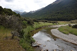
WKahurangi National Park in the northwest of the South Island of New Zealand is the second largest of the thirteen national parks of New Zealand. It was gazetted in 1996 and covers 4,529 square kilometres (1,749 sq mi), ranging to near Golden Bay in the north. Much of what was the North-west Nelson Forest Park formed the basis of the new park. Kahurangi Point, regarded as the boundary between the West Coast and Tasman Regions, is located in the park, as are the Heaphy Track and Mount Owen.
 W
WThe Tasman Region's Clarke River is one of three rivers by that name in the South Island of New Zealand. It rises in the Kahurangi National Park from the eastern flanks of Mt Sodom and Mt Gomorrah flowing southeast then northeast before joining the Baton River 10 kilometres (6 mi) northwest of the township of Tapawera.
 W
WThe Cobb River is a river in the Tasman Region of New Zealand. It flows southeast from Lake Cobb on the northern slopes of Mount Cobb, in Kahurangi National Park, in the northwestern South Island. The river's waters are captured behind a dam to become the Cobb Reservoir; the outflow continues to join with the Tākaka River. The river is named for J.W. Cobb, a local mill owner, who discovered it.
WThe Dart River arises in the Kahurangi National Park between the Lookout and Hope Ranges in the Tasman Region of New Zealand. It flows northward to join the Wangapeka River, which is a tributary of the Motueka River.
 W
WThe Gunner River is a river on the West Coast of New Zealand. It rises in the Domett Range in the Kahurangi National Park and flows north-west into the Heaphy River, which flows into the Tasman Sea.
 W
WThe Heaphy River is a river of the northwestern South Island of New Zealand. It flows through Kahurangi National Park, rising on the northern slopes of Amohia Peak and initially flowing northwest before turning southwest to reach the Tasman Sea 30 kilometres north of Karamea. Stages of the Heaphy Track follow the lower course of this river, with the track reaching the coast at the river's mouth.
 W
WThe Heaphy Track is a popular tramping track in the north west of the South Island of New Zealand. It is located within the Kahurangi National Park and classified as one of New Zealand's nine Great Walks by the Department of Conservation. Named after Charles Heaphy, the track is 78.4 kilometres (48.7 mi) long and is usually walked in four or five days. The track runs from Kohaihai, north of Karamea on the northern west coast of the South Island to the upper valley of the Aorere River, inland from Golden Bay.
 W
WHoneycomb Hill Cave is located in the Oparara Basin, on the northwestern edge of the South Island of New Zealand. The Oparara River flows through a section of the cave.
 W
WKahurangi Point is a headland on the West Coast of New Zealand's South Island, overlooking the Tasman Sea. It is located in Kahurangi National Park between Karamea and Farewell Spit.
 W
WThe Karamea River is a river of New Zealand. It is located in the Tasman and West Coast Regions of the South Island. The river rises within Kahurangi National Park in the Matiri Range of the Southern Alps. The river rises to the east of Mount Allen, meandering west briefly before turning north. After some 25 kilometres it again turns west, to enter a series of small lakes where its waters are joined by those of the Roaring Lion River.
 W
WThe Kohaihai River is a river of the northwest of New Zealand's South Island. Flowing southwest and then west from the Dommett Range, the river's entire length is within the Kahurangi National Park. The river's mouth marks the south western end of the Heaphy Track and the northern terminus of the West Coast's road system. The nearest town is Karamea.
 W
WMount Arthur is in the Arthur Range in the north western area of the South Island of New Zealand. Mount Arthur, named after Captain Arthur Wakefield, lies within Kahurangi National Park and has a peak elevation of 1,795 metres (5,889 ft).
WThe Onahau River is a river of the Tasman Region of New Zealand's South Island. It has its sources close to the northernmost point of Kahurangi National Park, from where it flows northeast to reach Golden Bay to the northwest of Takaka. The smaller Little Onahau River follows a roughly parallel course to the southwest of the Onahau River.
WMount Owen is in the Tasman district of the South Island of New Zealand. It stands at 1875 metres (6150 feet) above sea level and is part of the Marino Mountains.
 W
WThe Wangapeka River is a river of the Tasman Region of New Zealand's South Island. It rises in two branches, the North Branch and the South Branch, in the Matiri Range within Kahurangi National Park, meeting some 25 kilometres southeast of Karamea. It flows generally northeast to reach the Motueka River 30 kilometres south of Motueka.