 W
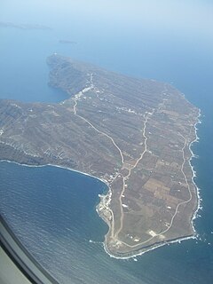
WAnafi, anciently, Anaphe, is a Greek island community in the Cyclades. In 2011, it had a population of 271. Its land area is 40.370 square kilometres. It lies east of the island of Thíra (Santorini). Anafi is part of the Thira regional unit.
 W
WAspronisi is an uninhabited island lying within the Santorini caldera. The island was originally formed by the massive Minoan eruption in the 2nd millennium BC, after which it was gradually built up by successive volcanic activity. The name Aspronisi, which means 'White Island' in Greek, is derived from the island being partially composed of white pumice.
 W
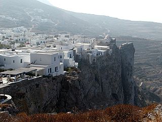
WFolegandros is a small Greek island in the Aegean Sea that, together with Sikinos, Ios, Anafi and Santorini, forms the southern part of the Cyclades. Its surface area is 32.216 square kilometres (12.439 sq mi) and it has 765 inhabitants. It has three small villages, Chora, Karavostasis, and Ano Meria, which are connected by a paved road. Folegandros is part of the Thira regional unit.
 W
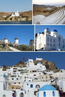
WIos, Io or Nio is a Greek island in the Cyclades group in the Aegean Sea. Ios is a hilly island with cliffs down to the sea on most sides, situated halfway between Naxos and Santorini. It is about 18 kilometres long and 10 kilometres wide, with an area of 109.024 square kilometres (42.094 sq mi). Population was 2,024 in 2011. Ios is part of the Thira regional unit.
 W
WKardiotissa, anciently, Lagusa or Lagousa or Lagussa or Lagoussa (Λαγοῦσσα), is a Greek island in the Cyclades. It is uninhabited and administratively a part of the island community of Sikinos. It lies midway between that island and the island of Folegandros.
 W
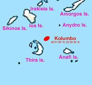
WKolumbo is an active submarine volcano in the Aegean Sea, about 8 km northeast of Cape Kolumbo, Santorini island. The largest of a line of about twenty submarine volcanic cones extending to the northeast from Santorini, it is about 3 km in diameter with a crater 1.5 km across. It was "discovered" when it breached the sea surface in 1649-50, but its explosion was not to be compared to the well-known Thera explosion and caldera collapse, currently dated ca. 1630 BCE, with its devastating consequences for Minoan civilization. The Smithsonian Institution's Global Volcanism Program treats it as part of the Santorini volcano.
 W
WThe Minoan eruption was a major catastrophic volcanic eruption that devastated the Aegean island of Thera in around 1600 BCE. It destroyed the Minoan settlement at Akrotiri, as well as communities and agricultural areas on nearby islands and the coast of Crete with subsequent earthquakes and tsunamis. With a VEI magnitude between 6 and 7, resulting in an ejection of approximately 60 km3 (14 cu mi) of dense-rock equivalent (DRE), the eruption was one of the largest volcanic events on Earth in human history.
WNea Kameni is a small uninhabited Greek island of volcanic origin located in the Aegean Sea, within the flooded Santorini caldera. Nea Kameni and the neighbouring small island Palea Kameni have formed over the past two millennia through repeated eruptions of dacite lava and ash. The Roman historian Cassius Dio records in the year 47 CE "This year a small islet, hitherto unknown, made an appearance close to the island of Thera." Cassius' report may refer to Palaia Kameni. Pliny the Elder reports a new island emerging during on July 8, in the year of the consulship of M. Junius Silanus and L. Balbus, thus 19 CE.
 W
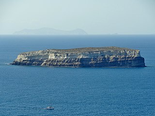
WPachia is an uninhabited Greek island in the Cyclades in the south of Anafi.
 W
WPalea Kameni, also known as Palia Kameni, is a volcanic island within the Santorini Caldera. The island was formed by a series of volcanic eruptions that formed large deposits of pumice and dacite. The island's name translates to "Old Burnt Island".
 W
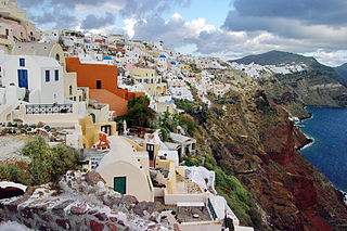
WSantorini, officially Thira and classic Greek Thera, is an island in the southern Aegean Sea, about 200 km (120 mi) southeast from Greece. Its the largest island of a small, circular archipelago, which bears the same name and is the remnant of a volcanic caldera. It forms the southernmost member of the Cyclades group of islands, with an area of approximately 73 km2 (28 sq mi) and a 2011 census population of 15,550. The municipality of Santorini includes the inhabited islands of Santorini and Therasia, as well as the uninhabited islands of Nea Kameni, Palaia Kameni, Aspronisi and Christiana. The total land area is 90.623 km2 (34.990 sq mi). Santorini is part of the Thira regional unit.
 W
WSantorini caldera is a large, mostly submerged caldera, located in the southern Aegean Sea, 120 kilometers north of Crete in Greece. Visible above water is the circular Santorini island group, consisting of Santorini, the main island, Therasia and Aspronisi at the periphery, and the Kameni islands at the center. It has been designated a Decade Volcano.
 W
WThe Sea of Crete or Cretan Sea, is a sea, part of the Aegean Sea, located in its Southern extremity. The sea stretches to the North of the island of Crete, East of the islands of Kythera and Antikythera, South of the Cyclades, and West of the Dodecanese islands of Rhodes, Karpathos and Kassos. The bounding sea to the West is the Ionian Sea. To the Northwest is the Myrtoan Sea, a subdivision of the Mediterranean Sea that lies between the Cyclades and Peloponnese. To the East-SE is the rest of the Mediterranean Sea, sometimes credited as the Levantine Sea. Across the island of Crete, to the opposite shore of it begins the Libyan Sea. Ferry routes to and from Piraeus and Heraklion, as well as the Southern islands of the Aegean and the Dodecanese, run in this area. Just off the coastline of Northeastern Crete the sea reaches a maximum depth of near 3,294 m. Other sources (maps) show a maximum depth of 2,591 m..
 W
WSikinos is a Greek island and municipality in the Cyclades. It is located midway between the islands of Ios and Folegandros. Sikinos is part of the Thira regional unit.
 W
WTherasia, also known as Thirasía, is an island in the volcanic island group of Santorini in the Greek Cyclades. It lies north-west of Nea Kameni, a small island formed in recent centuries by volcanic activity and thus marking the centre of the island group. Therasia is the second largest island of the group, the largest by far being Thera.