 W
WRivers in Honduras is a list of the rivers in Honduras, including those it shares with neighbours. Among the most important river in Honduras is the Ulúa, which flows 400 kilometres (250 mi) through the economically important Valle de Sula. Numerous other rivers drain the interior highlands and empty north into the Caribbean Sea. The Pacific Ocean coast also receives other important rivers such as the Choluteca River, which flows through the capital, Tegucigalpa, where it wreaked havoc during the 1998 Hurricane Mitch. La Quebradona is a river located in La Ruidosa, Copán. La Comisión Permanente de Contingencias is the body which gives out alerts when rivers are in danger of overflowing.
 W
WThe Aguán River ; also commonly known by its Spanish name, Rio Aguán) is a river in Honduras. It rises in the Yoro region to the west of San Lorenzo and briefly runs south before turning east-northeast, passing San Lorenzo, Olanchito and Tocoa before entering the Caribbean Sea east of Puerto Castilla.
WThe Cangrejal River or Río Cangrejal is a river that drains several mountain tributaries and borders the rainforest of Pico Bonito National Park near La Ceiba, Honduras. The river offers some of the best whitewater rafting opportunities in Central America.
 W
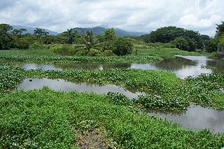
WThe Choluteca River is a river in southern Honduras. Its source is in the Department of Francisco Morazán, near Lepaterique, and from there it flows north through the city of Tegucigalpa, then south through the department of El Paraíso, and the department and city of Choluteca. The mouth of the river—located among wetland—is near the coastal town of Cedeño, on the Gulf of Fonseca.
 W
WThe Río Coco, formerly known as the Río Segovia, Cape River, or Yara River, is a river in northern Nicaragua and southern Honduras. The Miskito Indians who live along the river know it as the Wanki or Wanks River. It is the longest river that runs entirely within the Central American isthmus.
 W
WThe Goascorán River or Río Goascorán is a river in Honduras and El Salvador that divides the two countries.
 W
WThe Gualcarque River is a river in Intibucá, western Honduras. It is sacred to the indigenous Lenca, who depend on the river for their subsistence. It is the site of the proposed Agua Zarca hydroelectric dam, a joint Honduran-Chinese project.
 W
WThe Guayape River is a major river that drains much of the Department of Olancho and central Honduras. The largest tributary to the Guayape is the Río Jalán, which joins it at El Plomo, not far from the town of Juticalpa. From there the river passes many small towns, including El Esquilinchuche. The largest bridge over the Guayape is the Puente del Burro, a modern cement structure that replaced the huge steel suspension bridge that had stood for decades after being built by the US Army Corps of Engineers, and was destroyed by Hurricane Mitch in 1998. Far downriver from the bridge, the Guayape joins with the Guayambre River, from then on the waterway is known as the Río Patuca.
 W
WThe Jalan River is a river in Honduras.
 W
WThe Lempa River is a 422-kilometre (262 mi) long river in Central America.
 W
WThe Motagua River is a 486-kilometre-long (302 mi) river in Guatemala. It rises in the western highlands of Guatemala where it is also called Río Grande, and runs in an easterly direction to the Gulf of Honduras. The final few kilometres of the river form part of the Guatemala–Honduras border. The Motagua River basin covers an area of 12,670 square kilometres (4,890 sq mi) and is the largest in Guatemala.
 W
WThe Patuca is a river in northeastern Honduras, formed southeast of Juticalpa by the merger of the Guayape and Guayambre rivers. It is the second largest river in Central America and the longest river of Honduras, measuring almost 500 kilometres (310 mi) long and draining 23,900 square kilometres (9,200 sq mi).
 W
WThe Plátano River is a river in Honduras which runs through the Río Plátano Biosphere Reserve.
 W
WThe Tela River or Río Tela is a river that runs through Tela, in Honduras, flowing into the Caribbean Sea. It begins in a marshy area inland and opens out near the sea.
 W
WThe Ulúa River is a river in western Honduras. It rises in the central mountainous area of the country close to La Paz and runs 240 kilometres (150 mi) approximately due northwards to the east end of the Gulf of Honduras at 15°55′N 87°43′W. En route, it is joined by the Sulaco River, the Jicatuyo River, the Otoro River and the Chamelecón River. The Ulúa River valley is famed for its ornate calcite vessels that date from the Mayan times. One of them can be found in the British Museum's collection.