 W
WIn geology, a sill is a tabular sheet intrusion that has intruded between older layers of sedimentary rock, beds of volcanic lava or tuff, or along the direction of foliation in metamorphic rock. A sill is a concordant intrusive sheet, meaning that a sill does not cut across preexisting rock beds. Stacking of sills builds a sill complex and a large magma chamber at high magma flux. In contrast, a dike is a discordant intrusive sheet, which does cut across older rocks. Sills are fed by dikes, except in unusual locations where they form in nearly vertical beds attached directly to a magma source. The rocks must be brittle and fracture to create the planes along which the magma intrudes the parent rock bodies, whether this occurs along preexisting planes between sedimentary or volcanic beds or weakened planes related to foliation in metamorphic rock. These planes or weakened areas allow the intrusion of a thin sheet-like body of magma paralleling the existing bedding planes, concordant fracture zone, or foliations.
 W
WBarn Bluff is a mountain located in the Central Highlands region of Tasmania, Australia. The mountain is situated in the Cradle Mountain-Lake St Clair National Park at the junction of the easternmost points of the Murchison and Mackintosh river catchments.
 W
WCh'iyar Qullu is a volcanic centre in Bolivia. It is located in the Oruro Department, Ladislao Cabrera Province, Salinas de Garci Mendoza Municipality, northeast of Salinas de Garci Mendoza, near a maar named Jayu Quta.
 W
WThe Roque Cinchado is a rock formation, regarded as emblematic of the island of Tenerife. It lies within the Teide National Park in the municipality of La Orotava, near the volcano of the same name, in the heart of the island.
 W
WFair Head or Benmore is a 5 kilometre mountain cliff, close to the sea, at the north-eastern corner of County Antrim, Northern Ireland, whose rock face is formed into distinctive vertical columns like organ pipes. Fair Head is regarded as one of the best outdoor rock-climbing locations in Ireland, and its long cliff, up to 100 metres high in places, is considered one of the biggest expanses of climbable rock in Northwest Europe.
 W
WThe Maidens or Hulin Rocks are two islets and several skerries in the North Channel off County Antrim in Northern Ireland. The Eastern Maiden or Southern Rock lies about 9 km from the coast at Ballygalley, or 13 miles from Larne. The West Maiden or Northern Rock is about half a mile further out. Lighthouses were built on both rocks; the West Maiden was abandoned in 1903 and the East Maiden was automated in 1977.
 W
WMount McKay is a mafic sill located south of Thunder Bay, Ontario, Canada, on the Indian Reserve of the Fort William First Nation. It is the highest, most northern and best known of the Nor'Wester Mountains. It formed during a period of magmatic activity associated with the large Midcontinent Rift System about 1,100 million years ago.
 W
WThe Nipissing sills, also called the Nipissing diabase, is a large 2217– to 2210–million year old group of sills in the Superior craton of the Canadian Shield in Ontario, Canada, which intrude the Huronian Supergroup. Nipissing sills intrude all the Huronian sediments and older basement rocks in the northern margin of the Sudbury Basin; they were emplaced after the faulting and folding of Huronian rocks, and are hornblende gabbro of tholeiitic basalt composition. In the Sudbury–Elliot Lake area the Nipissing diabase is deformed; outcrops are parallel to the fold axes of the Huronian sedimentary rocks. Nipissing diabase intrusions are east-northeast trending and are no wider than 460 m (1,510 ft).
 W
WThe Nor'Wester Mountains are a group of mountains immediately south of Thunder Bay, Ontario, Canada, located on the southern limits of the City of Thunder Bay and south of the Kaministiquia River. Mount McKay is the highest, most northern and best known of these mountains. Other prominent peaks include Godfrey, Hurlburt, Johnson, Matchett, McRae, McQuaig, Rose, and Squaretop.
 W
WŌshima is a rocky island off the northern coast of Natsudomari Peninsula in Mutsu Bay. The island is a part of Hiranai in Aomori Prefecture. The island has 3 km (1.9 mi) of coastline and an area of 0.16 km2 (0.062 sq mi). It is a part of the prefecture-maintained, Asamushi-Natsudomari Prefectural Natural Park.
 W
WThe Palisades Sill is a Triassic, 200 Ma diabase intrusion. It extends through portions of New York and New Jersey. It is most noteworthy for The Palisades, the cliffs that rise steeply above the western bank of the Hudson River. The ideal location and accessibility of the sill, as well as its unique features, have generated much attention from nature enthusiasts, rock climbers, and geologists alike.
 W
WThe Palisades Sill is a fine-grained porphyritic dacite sill which forms spectacular cliffs and palisades in the Cimarron River canyon between Eagle Nest and Cimarron in northern New Mexico. It can be seen in the eastern part of Cimarron Canyon State Park.
 W
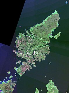
WThe Shiant Islands or Shiant Isles are a privately owned island group in the Minch, east of Harris in the Outer Hebrides of Scotland. They are five miles southeast of the Isle of Lewis.
 W
WThe Sleeping Giant is a series of mesas formed by the erosion of thick, basaltic sills on Sibley Peninsula which resembles a giant lying on its back when viewed from the west to north-northwest section of Thunder Bay, Ontario, Canada. As one moves southward along the shoreline toward Sawyer's Bay the Sleeping Giant starts to separate into its various sections. Most distinctly in the view from the cliffs at Sawyer's Bay the Giant appears to have an Adam's Apple. The formation is part of Sleeping Giant Provincial Park. Its dramatic steep cliffs are among the highest in Ontario. The southernmost point is known as Thunder Cape, depicted by many early Canadian artists such as William Armstrong.
 W
WThe Whin Sill or Great Whin Sill is a tabular layer of the igneous rock dolerite in County Durham, Northumberland and Cumbria in the northeast of England. It lies partly in the North Pennines Area of Outstanding Natural Beauty and partly in Northumberland National Park and stretches from Teesdale northwards towards Berwick.