 W
WThe Yarra River or historically, the Yarra Yarra River, is a perennial river in east-central Victoria, Australia.
 W
WCoode Island is a former island at the convergence of the Yarra and Maribyrnong Rivers, 4 km west of central Melbourne, Australia. The island was formed by the excavation of the Coode Canal in 1887, and became connected to the mainland in the 1930s. Today the low-lying land is part of the Port of Melbourne, and is used as the site of Swanson and Appleton Docks and their associated container storage and rail yards, as well as a number of chemical storage facilities.
 W
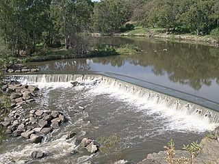
WDights Falls is a rapid and weir on the Yarra River in Melbourne, Victoria, just downstream of the junction with the Merri Creek. At this point the river narrows and is constricted between 800,000-year-old volcanic, basaltic lava flow and a much older steep, silurian, sedimentary spur. The north side also contains abundant graptolite fossils in sedimentary sandstone.
 W
WDocklands is an inner suburb of Melbourne, Victoria, Australia, 2 km (1.2 mi) west of the city's Central Business District (CBD). Its local government area is the City of Melbourne. At the 2016 Census, Docklands had a population of 10,964. Primarily a waterfront area centred on the banks of the Yarra River, it is bounded by Wurundjeri Way and the Charles Grimes Bridge to the east, CityLink to the west and Lorimer Street across the Yarra to the south.
 W
WHerring Island is a small 3.2 hectares artificial island located in Melbourne's Yarra River at South Yarra, approximately 3 kilometres (1.9 mi) from the city centre. It is the only island in the Yarra River.
 W
WThe Yarra Trail is a shared use path for cyclists and pedestrians, which follows the Yarra River through the north eastern suburbs of Melbourne, Victoria, Australia.
 W
WThe Yarra River is a river in southern Victoria, Australia that flows through the city of Melbourne. There are many parklands, including state parks and national parks, that adjoin the river along its 250 km length. Every park listed has walking tracks, smaller parks usually have unsealed paths, while bigger parks will have sealed pathways suitable for walking and cycling. The Yarra River Trail runs along much of the length of the river's lower reaches through Melbourne. Most parks listed have parking available, the quality and quantity of which varies according to the size of the park. Dogs are not permitted in parklands adjoining the river unless otherwise stated in special off-lead areas.
 W
WThe Pound Bend Tunnel, or the Evelyn Tunnel, is a diversion tunnel on the Yarra River at Warrandyte, Victoria, Australia, approximately 24 km north-east of Melbourne. The tunnel is 145 metres long, six metres wide and four metres deep.
 W
WSwanson Dock is an international shipping facility in Melbourne, Victoria, Australia. It was constructed between 1966 and 1972 by the Melbourne Harbour Trust, on the north bank of the Yarra River to alleviate congestion in the port and provide the first container shipping terminal in Melbourne. It is located about 2 km downstream from the Melbourne CBD and was named after Victor Swanson, Chairman of the Melbourne Harbour Trust between 1960 and 1972.
 W
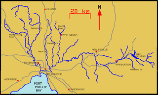
WThe Upper Yarra Reservoir is located east of Melbourne, beyond Warburton within the locality of Reefton. Water from Upper Yarra Reservoir supplies towns in the upper Yarra Valley, and Silvan Reservoir, which transfers water to most parts of Melbourne.
 W
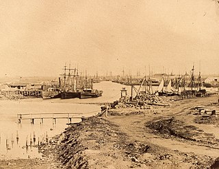
WVictoria Dock is a large excavated harbour basin located off Footscray Road and Docklands Highway, Docklands, in Melbourne. It was constructed between 1887 and 1892, under the supervision of Melbourne Harbour Trust engineer Joseph Brady, to modified designs of British engineer Sir John Coode.
WYarra Bend Park is a 260 hectare park in the Melbourne suburb of Kew. Located 4 km northeast of Melbourne's CBD, it is the largest area of natural bushland left in inner Melbourne. The most notable feature of the park is the Yarra River which flows for 12 km through it. The park hosts two golf courses, two historic boathouses, sheds and a number of cycle and walking trails. It receives approximately 1.5 million visitors per year.
 W
WYarra Falls was a waterfall on the Yarra River in Melbourne, Australia that was demolished in 1883 through the use of dynamite in order to prevent a repeat of the floods of 1863 and 1878. It formed a low barrier, separating the brackish tidal water found downstream from the fresh water found above it, and in doing so provided potable water for the young settlement.
 W
WThe Yarra River is a river in East-Central Victoria, Australia that flows through the city of Melbourne. This article contains explanations and lists of the river's tributaries and other geographic features. The river flows atop layers of silt that built up within an ancient river valley around 10,000-15,000 years ago.
 W
WThe Yarra Valley is the region surrounding the Yarra River in Victoria, Australia. The river originates approximately 240 kilometres east of the Melbourne central business district and flows towards it and out into Port Phillip Bay. The name Yarra Valley is used in reference to the upper regions surrounding the Yarra River and generally does not encompass the lower regions including the city and suburban areas, where the topography flattens out, or the upper reaches which are in inaccessible bushland. Included in the Yarra Valley is the sub-region of the Upper Yarra Valley which encompasses the towns of the former Shire of Upper Yarra in the catchment area upstream of and including Woori Yallock. The Yarra Valley is a popular day-trip and tourist area, featuring a range of natural features and agricultural produce, as well as the Lilydale to Warburton Rail Trail.