 W
WThe Chesapeake and Ohio Canal, abbreviated as the C&O Canal and occasionally called the "Grand Old Ditch," operated from 1831 until 1924 along the Potomac River from Washington, D.C., to Cumberland, Maryland. The canal's principal cargo was coal from the Allegheny Mountains.
 W
WThe Aqueduct Bridge was a bridge between Georgetown, Washington, D.C., and Rosslyn, Virginia. It was built to transport cargo-carrying boats on the Chesapeake and Ohio Canal in Georgetown across the Potomac River to the Alexandria Canal. The same eight piers supported two different bridges: a wooden canal bridge and an iron truss bridge carrying a roadway and an electric trolley line. The bridge was closed in 1923 after the construction of the nearby Key Bridge. The shuttered Aqueduct Bridge was demolished in 1933.
 W
WCanal Place is a 58.1-acre (235,000 m2) state park located in Cumberland, Maryland at the western terminus of the Chesapeake and Ohio Canal.
 W
WThe Chesapeake and Ohio Canal National Historical Park is located in the District of Columbia and the state of Maryland. The park was established in 1961 as a National Monument by President Dwight D. Eisenhower to preserve the neglected remains of the Chesapeake and Ohio Canal and many of its original structures. The canal and towpath trail extends along the Potomac River from Georgetown, Washington, D.C., to Cumberland, Maryland, a distance of 184.5 miles (296.9 km). In 2013, the path was designated as the first section of U.S. Bicycle Route 50.
 W
WThe Cumberland Dam was built across the North Branch of the Potomac River at Cumberland, Maryland, for the purpose of diverting water of the river into the head of the Chesapeake and Ohio Canal. The Chesapeake and Ohio Canal Company began construction of its Dam No. 8 in 1837 and work proceeded intermittently, finally concluding in 1850. The dam impounded water over a distance of a mile, causing back water for about 3 miles (4.8 km) up the river. Above the dam is the mouth of Wills Creek.
 W
WDierssen Wildlife Management Area is a Wildlife Management Area (WMA) near Seneca in Montgomery County, Maryland.
 W
WThe Locks on the Chesapeake and Ohio Canal, located in Maryland, West Virginia, and Washington, D.C. of the United States, were of three types: lift locks; river locks; and guard, or inlet, locks.
 W
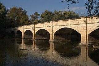
WThe Monocacy Aqueduct — or C&O Canal Aqueduct No. 2 — is the largest aqueduct on the Chesapeake and Ohio Canal, crossing the Monocacy River just before it empties into the Potomac River in Frederick County, Maryland, USA. The 438 foot aqueduct was built by three separate contractors between 1829 and 1833 at a cost of US$127,900.
 W
WThe Paw Paw Tunnel is a 3,118-foot-long (950 m) canal tunnel on the Chesapeake and Ohio Canal (C&O) in Allegany County, Maryland. Located near Paw Paw, West Virginia, it was built to bypass the Paw Paw Bends, a six-mile (9.7 km) stretch of the Potomac River containing five horseshoe-shaped bends. The town, the bends, and the tunnel take their name from the pawpaw trees that grow prolifically along nearby ridges.
 W
WThe Pennyfield Lock and lockhouse are part of the 184.5-mile (296.9 km) Chesapeake and Ohio Canal that operated in the United States along the Potomac River from the 1830s through 1923. The lock, located at towpath mile-marker 19.7, is near River Road in Montgomery County, Maryland. The original lock house was built in 1830, and its lock was completed in 1831.
 W
WPower Plant and Dam No. 4 is a historic hydroelectric power generation station on the Potomac River, located near Shepherdstown on the county line between Berkeley and Jefferson County, West Virginia. The power plant is a tall one-story, limestone building on a high stone foundation. It is five bays long and has a gable roof. Dam 4 uses horizontal shaft turbines connected by rope drives to horizontal shaft generators. This plant is probably the last commercially operated rope-driven hydroelectric plant in the United States. The building is built into a hillside, so the main floor is the top floor. The power plant was originally built by the Martinsburg Electric Company.
 W
WPower Plant and Dam No. 5, also known as Honeywood Dam, comprises a dam on the Potomac River, originally built for the Chesapeake and Ohio Canal, and a power plant built to take advantage of the river's flow to generate hydroelectric power. The dam is included in Chesapeake and Ohio Canal National Historical Park.
 W
WRiley's Lock (Lock 24) and lock house are part of the 184.5-mile (296.9 km) Chesapeake and Ohio Canal that operated in the United States along the Potomac River from the 1830s through 1923. They are located at towpath mile-marker 22.7 adjacent to Seneca Creek, in Montgomery County, Maryland. The lock is sometimes identified as Seneca because of the Seneca Aqueduct that carried the canal over the creek to the lift lock. The name Riley comes from John C. Riley, who was lock keeper from 1892 until the canal closed permanently in 1924.
 W
WSeneca Aqueduct — or Aqueduct No. 1 — is a naviduct that carries the Chesapeake and Ohio Canal (C&O) over Seneca Creek in Montgomery County, Maryland. The C&O built eleven aqueducts along its 184.5 miles (296.9 km) length. Seneca Aqueduct is a unique structure, not only being the first built, but also the only red sandstone aqueduct on the C&O−and the only aqueduct that is also a lock. It is located at the end of Riley's Lock Road in Seneca, Maryland.
 W
WSwains Lock and lock house are part of the 184.5-mile (296.9 km) Chesapeake and Ohio Canal that operated in the United States along the Potomac River from the 1830s through 1923. It is located at towpath mile-marker 16.7 near Potomac, Maryland, and within the Travilah census-designated place in Montgomery County, Maryland. The lock and lock house were built in the early 1830s and began operating shortly thereafter.
 W
WThe Tidewater Lock is a dam in Washington, D.C. to the west of the mouth of Rock Creek at the Potomac River, on the east side of Georgetown. Built to connect the Chesapeake and Ohio Canal, opened in 1831, with the Potomac, it was a busy maritime intersection during several decades of the canal's heyday. C&O documents refer to it variously as Lock 0 and Tide Lock A.