 W
WAbriachan, is a village in the Highland council area of Scotland. It is situated high above the western shore of Loch Ness, 15 km to the south-west of the city of Inverness. The village has a population of approximately 120. There are no schools in Abriachan, so children travel by bus into Inverness or to Dochgarroch for their education.
 W
WAssynt is a sparsely populated area in the south-west of Sutherland, lying north of Ullapool on the west coast of Scotland. Assynt is known for its landscape and its remarkable mountains, which have led to the area, along with neighbouring Coigach, being designated as the Assynt-Coigach National Scenic Area, one of 40 such areas in Scotland.
 W
WBenbecula is an island of the Outer Hebrides in the Atlantic Ocean off the west coast of Scotland. In the 2011 census, it had a resident population of 1,283 with a sizable percentage of Roman Catholics. It is in a zone administered by Comhairle nan Eilean Siar or the Western Isles Council.
The Bridgend Farmhouse Community Project in Edinburgh, Scotland is a community-owned and community-run charitable organisation. The project restored an 18th century farmhouse to provide a community meeting place, café, garden and workshops. The project runs classes, workshops and training courses in a variety of crafts and skills aimed at all age groups. It also provides facilities for performances, gatherings, talks, entertainment and small conferences. Given charitable status under the title Bridgend Inspiring Growth (BIG), the project was one of the first in Scotland to achieve community ownership in an urban setting. In 2018 it became the first organisation in Scotland to transfer from a Scottish Charitable Incorporated Organisation (SCIO) to a Community Benefit Society with charitable status.
 W
WCultybraggan Camp lies close to the village of Comrie, in west Perthshire. It was first used as a prisoner of war (PoW) camp during World War II, and then became an Army training area. It later housed a Royal Observer Corps (ROC) nuclear monitoring post, and a Regional Government Headquarters (RGHQ).
 W
WEigg is one of the Small Isles, in the Scottish Inner Hebrides. It lies to the south of the Isle of Skye and to the north of the Ardnamurchan peninsula. Eigg is 9 kilometres long from north to south, and 5 km (3 mi) east to west. With an area of 12 sq mi (31 km2), it is the second largest of the Small Isles after Rùm. Eigg generates virtually all of its electricity using renewable energy.
 W
WEriskay, from the Old Norse for "Eric's Isle", is an island and community council area of the Outer Hebrides in northern Scotland with a population of 143, as of the 2011 census. It lies between South Uist and Barra and is connected to South Uist by a causeway which was opened in 2001. In the same year Ceann a' Ghàraidh in Eriskay became the ferry terminal for travelling between South Uist and Barra. The Caledonian MacBrayne vehicular ferry travels between Eriskay and Ardmore in Barra. The crossing takes around 40 minutes.
 W
WGigha ; Scottish Gaelic: Giogha; Scots: Gigha) or the Isle of Gigha is an island off the west coast of Kintyre in Scotland. The island forms part of Argyll and Bute and has a population of 163 people. The climate is mild with higher than average sunshine hours and the soils are fertile. The main settlement is Ardminish.
 W
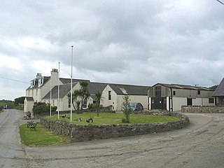
WGlendale is a community-owned estate on the north-western coastline of the Duirinish peninsula on the island of Skye and is in the Scottish council area of Highland. The estate encompasses the small crofting townships of Skinidin, Colbost, Fasach, Glasphein, Holmisdale, Lephin, Hamaraverin, Borrodale, Milovaig and Waterstein, Feriniquarrie, Totaig, Glasphein, Hamara, and others
 W
WHarris is the southern and more mountainous part of Lewis and Harris, the largest island in the Outer Hebrides, Scotland. Although not an island itself, Harris is often referred to as the Isle of Harris, which is the former postal county and the current post town for Royal Mail postcodes starting HS3 or HS5; see HS postcode area.
 W
WKnoydart is a peninsula in Lochaber, Highland, on the west coast of Scotland. Knoydart is sandwiched between Lochs Nevis and Hourn — often translated as "Loch Heaven" and "Loch Hell" respectively, although the somewhat poetic nature of these derivations is disputed. Forming the northern part of what is traditionally known as na Garbh-Chrìochan or "the Rough Bounds", because of its harsh terrain and remoteness, Knoydart is also referred to as "Britain's last wilderness". It is only accessible by boat, or by a 16-mile (26 km) walk through rough country, and the seven miles (11 km) of tarred road are not connected to the UK road system.
 W
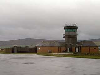
WRoyal Air Force Machrihanish or RAF Machrihanish is a former Royal Air Force station located near the town of Machrihanish and 3.5 miles (5.6 km) west of Campbeltown, at the tip of the Kintyre peninsula, Argyll and Bute, in Scotland.
 W
WRùm, a Scottish Gaelic name often anglicised to Rum, is one of the Small Isles of the Inner Hebrides, in the district of Lochaber, Scotland. For much of the 20th century the name became Rhum, a spelling invented by the former owner, Sir George Bullough, because he did not relish the idea of having the title "Laird of Rum".
 W
WSouth Uist is the second-largest island of the Outer Hebrides in Scotland. At the 2011 census, it had a usually resident population of 1,754: a decrease of 64 since 2001. The island, in common with the rest of the Hebrides, is one of the last remaining strongholds of the Gaelic language in Scotland. South Uist's inhabitants are known in Gaelic as Deasaich (Southerners). The population is about 90% Roman Catholic.
 W
WStornoway is the main town of the Western Isles and the capital of Lewis and Harris in Scotland.
 W
WUlva is an island in the Inner Hebrides of Scotland, off the west coast of Mull. It is separated from Mull by a narrow strait, and connected to the neighbouring island of Gometra by a bridge. Much of the island is formed from Cenozoic basalt rocks, which are formed into columns in places.