 W
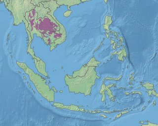
WThe Cardamom Mountains rain forests is a tropical moist broadleaf forest ecoregion in Southeast Asia, as identified by the WWF. The ecoregion covers the Cardamom Mountains and Elephant Mountains and the adjacent coastal lowlands in eastern Thailand and southwestern Cambodia, as well as the Vietnamese island of Dao Phu Quoc.
 W
WThe Central Indochina dry forests are a large tropical and subtropical dry broadleaf forests ecoregion in Southeast Asia.
 W
WThe Indochina mangroves are a large mangrove ecoregion on the coasts of Thailand, Cambodia, Vietnam and Malaysia in Southeast Asia.
 W
WThe Luang Prabang montane rain forests ecoregion covers elevations over 800 meters in the Luang Prabang mountains that straddle the border between northern Thailand and north-central Laos, and the highlands that stretch eastward across north-central Laos. While much of the forest cover has been degraded, there are still large areas of relatively untouched forest.
 W
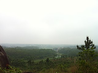
WThe Northern Annamites rain forests ecoregion covers the rugged and relatively unexplored northern Annamite Mountains of central Laos and Vietnam. There are high numbers of endemic plant species, and the relative remoteness and isolation of the area supports many rare and endangered animals. Rainfall is somewhat less than the lowland rainforest of the lower elevations in Vietnam, and the temperatures slightly cooler due to the higher altitude.
 W
WThe Northern Indochina subtropical moist forests are a subtropical moist broadleaf forest ecoregion of northern Indochina, covering portions of Vietnam, Laos, Thailand, Myanmar, and China's Yunnan Province.
 W
WThe Northern Vietnam lowland rain forests ecoregion covers the central eastern coast of Vietnam from the Red River delta in the north to Tam Kỳ in the center of the country. The region is one of wet evergreen forests, with rain over 50 mm in every month. The forests have been highly degraded by human use, and the high levels of biodiversity have been pushed back into relatively small protected areas like Pu Mat National Park.
 W
WThe Red River freshwater swamp forests ecoregion covers the freshwater portion of the Hong River delta in northern Vietnam. The ecoregion is separated from the sea by a thin coastal strip of the saltwater mangroves of the Indochina mangroves ecoregion. Very little of the little ecosystem remains; most of the delta has been converted to urbanization, industry, or agriculture. Less than 1% of the ecoregion is protected in significantly sized tracts.
 W
WThe South China Sea Islands consist of over 250 islands, atolls, cays, shoals, reefs and seamounts in the South China Sea. The islands are mostly low and small, and have few inhabitants. The islands and surrounding seas are subject to overlapping territorial claims by the countries bordering the South China Sea.
 W
WThe South China-Vietnam subtropical evergreen forests ecoregion covers the mountainous coastal region of southeastern China and northeastern Vietnam. The ecoregional also covers the coastal plain along the South China Sea and Hainan Island. The area has significant biodoversity and ecological importance, with high levels of both endemic and threatened species. Rapid urban expansion is reducing biologically-rich forests and wetlands. Ecologically, the suptropical forests are at the northeastern extent of the Indomalayan realm.
 W
WSoutheast Asian coral reefs have the highest levels of biodiversity for the world's marine ecosystems. They serve many functions, such as forming the livelihood for subsistence fishermen and even function as jewelry and construction materials. Coral reefs are developed by the carbonate-based skeletons of a variety of animals and algae. Slowly and overtime, the reefs build up to the surface in oceans. Coral reefs are found in shallow, warm salt water. The sunlight filters through clear water and allows microscopic organisms to live and reproduce. The Indian Ocean holds 60% of the world's coastal reefs, 25% are in the Pacific and 15% are in the western Atlantic. There are coral reefs in the Persian Gulf, Madagascar, the Philippines, Hawaiian Islands and off Southeast Asia. Coral reefs have been preserved and identified in rocks over 400 million years old. Coral reefs are actually composed of tiny, fragile animals known as coral polyps. Coral reefs are significantly important because of the biodiversity. Although the number of fish are decreasing, the remaining coral reefs contain more unique sea creatures. The variety of species living on a coral reef is greater than anywhere else in the world. An estimation of 70-90% of fish caught are dependent on coral reefs in Southeast Asia and reefs support over 25% of all known marine species. However, those sensitive coral reefs are facing detrimental effects on them due to variety of factors: overfishing, sedimentation and pollution, bleaching, and even tourist-related damage.
 W
WThe Southeastern Indochina dry evergreen forests are a tropical dry broadleaf forest ecoregion of Indochina.
 W
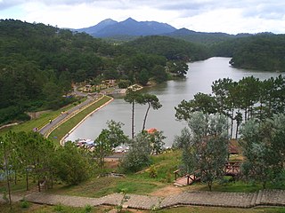
WThe Southern Annamites montane rain forests ecoregion covers a region of high bidiversity in the central and southern mountains of the Annamite Range in Vietnam. Terrain ranges from wet lowland forest to evergreen hardwood and conifer montane rain forest. There is a short dry season centered on January–February, but fog and dew are common throughout the year and support a lush forest character.
 W
WThe Southern Vietnam lowland dry forests ecoregion covers the low, relatively arid coastal strip of southern Vietnam on the South China Sea. The region is in the rain shadow of the Southern Annamite Range, which blocks humid air from the west. Although approximately half of the ecoregion is forested to some degree, most has at some point been cleared for agriculture or degraded by extraction of hardwoods. There are few protected areas.
 W
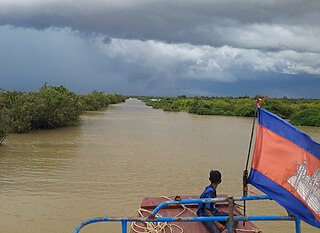
WThe Tonle Sap freshwater swamp forests ecoregion covers the seasonally flooded forests surrounding Tonlé Sap, the largest lake in Cambodia, and the floodplains of its connections to the Mekong River. Over 35% of the ecoregion experiences flooding during the wet season.
 W
WThe Tonle Sap-Mekong peat swamp forests ecoregion covers a patchwork of areas permanently inundated with fresh water along the Tonle Sap River and Mekong River floodplains in Cambodia and Vietnam. The terrain is mostly flat, with extensive agricultural fields, reed beds, and degraded shrub forest. Less than 10% of the region is in its original state, and less than 1% is protected. Habitat in the region is distinguished from the Tonle Sap freshwater swamp forests ecoregion that runs through the middle, as that ecoregion is only seasonally flooded.