 W
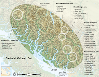
WThe Garibaldi Volcanic Belt is a northwest-southeast trending volcanic chain in the Pacific Ranges of the Coast Mountains that extends from Watts Point in the south to the Ha-Iltzuk Icefield in the north. This chain of volcanoes is located in southwestern British Columbia, Canada. It forms the northernmost segment of the Cascade Volcanic Arc, which includes Mount St. Helens and Mount Baker. Most volcanoes of the Garibaldi chain are dormant stratovolcanoes and subglacial volcanoes that have been eroded by glacial ice. Less common volcanic landforms include cinder cones, volcanic plugs, lava domes and calderas. These diverse formations were created by different styles of volcanic activity, including Peléan and Plinian eruptions.
 W
WAtwell Peak is a dramatic pyramid shaped volcanic peak located at the southern edge of Mount Garibaldi, British Columbia, Canada. Atwell Peak was formed during an initial period of volcanism 0.51-0.22 million years ago and was the source of many pyroclastic flows during Garibaldi's development. Frequent landslides on its west face drops steeply into the Cheekye River. Atwell Peak is often mistakenly called Mount Garibaldi when viewed from Squamish, since the main peak is hidden. The peak is usually climbed during winter or early spring when the rock is frozen because it is very loose and rotten. Atwell Peak contains three ridges, the north, east, and south. The two most visible routes are the north and south ridges.
 W
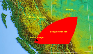
WThe Bridge River Ash is a large geologically recent volcanic ash deposit that spans from southwestern British Columbia to central Alberta, Canada. The ash consists of dust-sized shards ellipsoidal fragments of pumice. It overlaps the Mount St. Helens Yn Ash and the Mazama Ash which were erupted from Mount St. Helens and Mount Mazama about 3,400 and 6,800 years ago.
 W
WMount Callaghan is a volcanic peak located east of the headwaters of the Squamish River, just northeast of the Powder Mountain Icefield and just south of the Pemberton Icefield in the Sea to Sky Country of southwestern British Columbia, Canada, about 20 km directly west of the Resort Municipality of Whistler. A crack was observed across Callaghan's summit in the spring of 1999. In 2000, a section of the summit collapsed. Callaghan Lake lies below the south face of the mountain.
WThe Castle is a lava spine located west of Squamish in southwestern British Columbia, Canada. Volcanism at The Castle is controlled by north-south structures and there are no hot springs known in the area. It forms part of the Monmouth Creek complex and is part of the Garibaldi Volcanic Belt which is a segment of the Cascade Volcanic Arc.
 W
WMount Cayley is a mountain and highest point of the Mount Cayley massif between the Cheakamus and Squamish rivers in British Columbia, Canada. It has an elevation of 2,385 m (7,825 ft).
 W
WThe Cheakamus Valley basalts are a sequence of basaltic lava flows along the Cheakamus River in southwestern British Columbia, Canada. They are part of the Garibaldi section of the Cascade Volcanic Arc and were produced during an episode of volcanic eruptions from an unknown vent. The latest basaltic eruption deposited wood in lacustrine sediments under the lava flows that have been dated 34,200 ± 800 years old. These youngest lavas form isolated ridges above the older glaciated Cheakamus Valley basalts and were described as "esker-like" by Canadian volcanologist Bill Mathews.
 W
WThe Franklin Glacier Complex is a deeply eroded volcano in the Waddington Range of southwestern British Columbia, Canada. Located about 65 km (40 mi) northeast of Kingcome, this sketchily known complex resides at Franklin Glacier near Mount Waddington. It is over 2,000 m (6,600 ft) in elevation and because of its considerable overall altitude, a large proportion of the complex is covered by glacial ice.
 W
WMachmell River Cone is a cinder cone in the Silverthrone Caldera complex in the Pacific Ranges section of the Coast Mountains in British Columbia, Canada. It is believed the volcano last erupted during the Holocene, making it one of the most recent eruptions of the Silverthrone complex.
WThe Monmouth Creek complex is a volcanic complex in southwestern British Columbia, Canada, located 4 km (2.5 mi) southwest of the community of Squamish on the west side of the Squamish River mouth. It lies in the southern Pacific Ranges of the Coast Mountains and is part of the Squamish volcanic field in the southern Garibaldi Volcanic Belt, which represents the northernmost extension of the Cascade Volcanic Arc.
 W
WPyroclastic Peak is the second highest of the five named volcanic peaks immediately south of Mount Cayley in British Columbia, Canada. It is steep and rotten and is located 12 km (7 mi) southwest of Callaghan Lake and 24 km (15 mi) west of Whistler. It is part of the Pacific Ring of Fire that includes over 160 active volcanoes.
 W
WMount Silverthrone, officially named Silverthrone Mountain, is a mountain in the Pacific Ranges of the Coast Mountains of British Columbia, Canada, located over 320 km (200 mi) northwest of the city of Vancouver and about 50 km (30 mi) west of Mount Waddington, British Columbia, Canada. It is the highest peak in the Ha-Iltzuk Icefield, which is the largest icefield in the Coast Mountains south of the Alaska Panhandle.
 W
WThe Silverthrone Caldera is a potentially active caldera complex in southwestern British Columbia, Canada, located over 350 kilometres (220 mi) northwest of the city of Vancouver and about 50 kilometres (31 mi) west of Mount Waddington in the Pacific Ranges of the Coast Mountains. The caldera is one of the largest of the few calderas in western Canada, measuring about 30 kilometres (19 mi) long (north-south) and 20 kilometres (12 mi) wide (east-west). Mount Silverthrone, an eroded lava dome on the caldera's northern flank that is 2,864 metres (9,396 ft) high, may be the highest volcano in Canada.
 W
WThe Squamish volcanic field is a small north-south trending volcanic field on the South Coast of British Columbia, Canada. It extends for only about 3 km (1.9 mi) from the eastern side of Howe Sound northeast of Britannia Beach to the heavily forested slope on the western side of the Squamish River mouth. It forms the southernmost end of the Garibaldi Volcanic Belt, which comprises part of the Canadian Cascade Arc. Its volcanoes are relatively minor to the more voluminous stratovolcanoes found throughout the Garibaldi Belt and are composed of dacite and lesser basaltic andesite. The field gets its name from the nearby community of Squamish at the north end of Howe Sound on the Sea to Sky Highway.
 W
WThe Vulcan's Thumb is a rock pinnacle in the Pacific Ranges of southwestern British Columbia, Canada. It is the largest of a number of slender pinnacles protruding from the sharp summit ridge of Pyroclastic Peak, which forms part of the Mount Cayley massif.
WThe Watts Point volcanic centre is a small outcrop of Pleistocene age volcanic rock at Watts Point in British Columbia, Canada, about 10 kilometres (6 mi) south of Squamish and 40 kilometres (25 mi) north of Vancouver, and just north of Britannia Beach. It is the southernmost volcanic zone in the Squamish volcanic field and of the Garibaldi segment of the Cascade Volcanic Arc. The latest research indicates that it is most likely a subglacial mound. It comprises a continuous mass of sparsely porphyritic highly jointed dacitic lava overlying the mid-Cretaceous Coast Plutonic Complex and overlain locally by clay and of glacial till.