 W
WLake Amatitlán is a lake located within the Amatitlán caldera in south-central Guatemala, fairly close to Guatemala City. It lies in the central highlands, 1,186 m (3890 feet) above sea level. Its maximum depth is 33 m (108 feet) and an average of 18 m (59 feet). The lake is 11 km long and 3 km wide; with an area of 15.2 square kilometers (5.9 sq mi) and a water volume of 0.286 cubic kilometers.
 W
WLake Atitlán is a lake in the Guatemalan Highlands of the Sierra Madre mountain range. It is in the Sololá Department of southwestern Guatemala. It is the deepest lake in Central America.
 W
WLaguna de Ayarza is a crater lake in Guatemala. The lake is a caldera that was created some 20,000 years ago by a catastrophic eruption that destroyed a twinned volcano and blanketed the entire region with a layer of pumice. The lake has a surface area of 14 km² and a maximum depth of 230 m. The lake has a surface elevation of 1409 m.
 W
WLaguna Brava, also known as Yolnabaj is a karstic lake in Guatemala. It is situated in the municipality of Nentón (Huehuetenango), close to the border with Mexico. The lake is fed by several streams and subterraneous watercourses.
 W
WLaguna de Calderas is a crater lake in the municipality of Amatitlán, Guatemala, Guatemala. It is located approximately 6 km south of Lake Amatitlán and 3 km north of the currently active vent of the Pacaya volcano. The lake has a surface area of 11 ha and is situated at an altitude of 1778 m.
 W
WChicabal Lake is a Guatemalan lake sacred to the Mam Mayan people. The lake is located in the municipal boundary of the town of San Martín Sacatepéquez in the department of Quetzaltenango. A crater lake, Chicabal Lake was formed in the crater of Volcán Chicabal at an elevation of 2,712 meters. The terrain surrounding the lake is a cloud forest.
 W
WLake Chichoj is located near the city of San Cristóbal Verapaz, in the department of Alta Verapaz, in Guatemala. It is 1 km (0.62 mi) long, 0.5 km (0.31 mi) wide, with an area of 0.5 km2 (0.19 sq mi), an average water volume of 4.8 ± 0.1 m3 (169.5 ± 3.5 cu ft), and a maximum depth of 32 m (105 ft).
 W
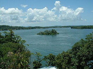
WLake El Golfete is a long narrow lake in Guatemala. It lies at sea level and is connected by the Dulce River from Lake Izabal draining to the Amatique Bay in the Caribbean Sea.
WEl Pino Lake is a lake in Guatemala. It is located 30 km south-southeast of Guatemala City, in the municipality of Barberena in the Santa Rosa Department. The lake has a surface area of 0.72 km² and a maximum depth of 18 m. The lake waters are used for subsistence fishing, sport fishing, and swimming.
 W
WLake Güija is a lake in Central America. The lake is situated on the border between Guatemala and El Salvador and has an area of 45 km², of which approximately 32 km² lies in El Salvador.
 W
WLaguna de Ipala is a crater lake in Guatemala. The lake is located in the south-eastern Chiquimula Department at the bottom of a 1 km wide crater of the Ipala Volcano. The lake has a surface area of 0.52 km² and is situated at an altitude of 1493 m.
 W
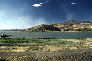
WLake Izabal, also known as the Golfo Dulce, is the largest lake in Guatemala with a surface area of 589.6 km² and a maximum depth is 18 m (59 ft). The Polochic River is the largest river that drains into the lake. The lake, which is only a metre above sea level, drains into the Gulf of Honduras of the Caribbean Sea through the smaller Golfete Dulce, which is at sea level, and the navigable Rio Dulce.
 W
WLachuá Lake is a karstic lake in Guatemala. It is located in the middle of a national park covered with tropical rain forest, northwest of Cobán, near the border between the departments of Alta Verapaz and El Quiché. The lake is near circular in shape and is probably a cenote or doline. The lake water has a slightly sulphurous smell, which may explain the origin of its name: "Lachuá" is derived from the Q'eqchi' words "la chu há" which means "the fetid water". The water contains a relatively high degree of calcite and tree branches fallen into the lake are quickly covered with a white calcite layer.
 W
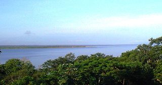
WLake Petén Itzá is a lake in the northern Petén Department in Guatemala. It is the second largest lake in Guatemala, after the Izabal Lake. It is located around 16°59′0″N 89°48′0″W. It has an area of 99 km² some 32 km. long and 5 km wide. Its maximum depth is 160 m. The lake area presents high levels of migration, due to the existence of natural resources such as wood, chewing gum, oil, and agricultural and pasture activities. Because of its archaeological richness, around 150,000 tourists pass through this region yearly. The city of Flores, the capital of El Petén, lies on an island near its southern shore.
 W
WPetexbatún is a small lake formed by a river of the same name, which is a tributary of the La Pasion river. It is near Sayaxché, located in the southern area of the Guatemalan department of Petén.
WYaxhá Lake is a Guatemalan lake situated in the northern department of El Petén.