 W
WThe Bōsō Peninsula is a peninsula that encompasses the entirety of Chiba Prefecture on Honshu, the largest island of Japan. It forms the eastern edge of Tokyo Bay, separating it from the Pacific Ocean. The peninsula covers approximately 5,034 square kilometres (1,944 sq mi).
 W
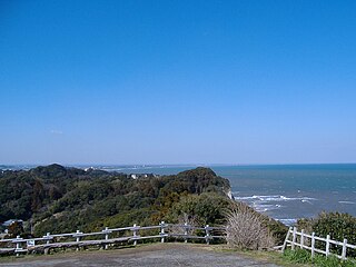
WByōbugaura is an inlet on the northeast coast of Chiba Prefecture that ranges from Cape Inubō in Chōshi to Cape Gyōbumi in Asahi. Byōbugaura is an important part of the coastal area in Chiba Prefecture, as it connects the northern point of the Pacific Ocean coast at Chōshi to Kujūkuri Beach, which covers a large portion of the western side of the prefecture. The name of the inlet is formed from the word "byōbu", the Japanese-style folding screen, and "ura", meaning an inlet. Byōbugaura resembles the White Cliffs of Dover on the English Channel. For this reason the inlet is sometimes called Tōyō no Dōbā (東洋のドーバー), or "Dover of the East". Byōbugaura is known for its long history of marine erosion.
 W
WCape Gyōbu is a cape on the Pacific Ocean, in the Iioka district of the city of Asahi, Chiba Prefecture, Japan. The cape is located at the very northern point of Kujūkuri Beach on the island of Honshu, and is protected as part of the Suigō-Tsukuba Quasi-National Park.
 W
WCape Hachiman is a cape on the Pacific Ocean, in the Ōhara area of the city of Isumi, in the southeast area of Chiba Prefecture, Japan. There are two Cape Hachimans located in close proximity to one another: Cape Hachiman in Isumi, and Cape Hachiman a few kilometers to the south in the city of Katsuura City. The cape is named after Hachiman, a mythological Japanese god of archery and war.
 W
WCape Hachiman is a cape on the Pacific Ocean, in the city of Katsuura, in the southeast area of Chiba Prefecture, Japan. There are two Cape Hachimans located in close proximity to one another: Cape Hachiman in Katsuura, and Cape Hachiman a few kilometers to the north in Isumi City. The cape is named after Hachiman, a mythological Japanese god of archery and war.
 W
WCape Inubō is a cape on the Pacific Ocean, in Chōshi, Chiba Prefecture, Japan. The cape is near the midpoint of the Japanese Archipelago on the island of Honshū.
 W
WCape Myōgane is a cape located on the border of Futtsu and Kyonan, Chiba, Japan, where Mount Nokogiri on its western end precipitously falls into the Uraga Channel to Tokyo Bay.
 W
WCape Suno is a cape on the Pacific Ocean, in the city of Tateyama, Chiba Prefecture, Japan. The cape is located at the southwestern point of Bōsō Peninsula on the island of Honshu, and marks the point between the inner and outer parts of the peninsula.
 W
WCape Taitō is a cape on the Pacific Ocean, in the city of Isumi, Chiba Prefecture, Japan. The cape is located at the very southern point of Kujūkuri Beach on the island of Honshu.
 W
WThe Kantō Plain is the largest plain in Japan, and is located in the Kantō region of central Honshū. The total area 17,000 km2 covers more than half of the region extending over Tokyo, Saitama Prefecture, Kanagawa Prefecture, Chiba Prefecture, Gunma Prefecture, Tochigi Prefecture and Ibaraki Prefecture.
 W
WKujūkuri Beach is a sandy beach that occupies much of the northeast coast of the Bōsō Peninsula in Chiba Prefecture, Japan. The beach is approximately 60 kilometres (37 mi) long, making it the second longest beach in Japan. Kujūkuri Beach is a popular swimming and surfing destination for inhabitants of Greater Tokyo. The beach is protected as part of Kujūkuri Prefectural Natural Park.
 W
WMineoka Mountain District is an area in the Bōsō Hill Range in the southern part of Chiba Prefecture. The Mineoka Mountain District runs along an east-west line across the southern part of the Bōsō Peninsula from the southern bank of the Kamo River in Kamogawa, facing the Pacific Ocean, to the Sakuma District of Kyonan, facing Tokyo Bay. The highest peak in the mountain district is at Mount Atago 408.2 m (1,339 ft) Mineoka is formed from two kanji characters: the first "嶺", meaning 'peak' or 'summit' and the second "岡" meaning 'mount' or 'hill.'
 W
WThe Shimōsa Plateau is a plateau on the Kantō Plain in central Honshu, Japan. The plateau covers most of northern Chiba Prefecture. The plateau was historically richly agricultural, but in the 20th century the western and central Shimōsa Plateau became one of the major industrial areas of Japan, as well as a large-scale bedroom community of the Tokyo Metropolitan Region. Narita International Airport is located in the center of the Shimōsa Plateau.
 W
WLake Tega is a lake located in the Chiba Prefecture of Japan, northeast of Tokyo.
 W
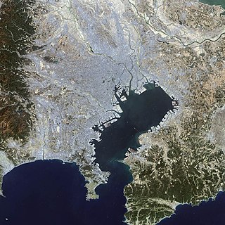
WTokyo Bay is a bay located in the southern Kantō region of Japan, and spans the coasts of Tokyo, Kanagawa Prefecture, and Chiba Prefecture. Tokyo Bay is connected to the Pacific Ocean by the Uraga Channel. Its old name was Edo Bay . The Tokyo Bay region is both the most populous and largest industrialized area in Japan.
 W
WYatsu-higata (谷津干潟) is a tidal flat in Narashino, Chiba Prefecture, Japan, 2 km from Tokyo Bay. Once a part of the largest tidal flats in Japan, much of the area has been reclaimed. Forty hectares of wetland were designated a Ramsar Site in 1993.