 W
WThe Balkan mountain range is a mountain range in the eastern part of the Balkan Peninsula. The range runs 557 km from the Vrashka Chuka Peak on Bulgarian-Serbian border eastward through central Bulgaria to foothills reaching Cape Emine on the Black Sea. The highest peaks of the Balkan Mountains are in central Bulgaria. The highest peak is Botev at 2,376 m, which makes the mountain range the third highest in the country, after Rila and Pirin. The mountains are the source of the name of the Balkan Peninsula.
 W
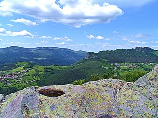
WBelintash is a small plateau in the Rhodope Mountains in Bulgaria bearing traces of human activity. It is assumed that this is a cult site of the ancient Thracian, though the very essence and purpose are not yet fully understood. There are also suggestions that the sanctuary was dedicated to the god Sabazios built and operated by the independent Thracian tribe Bessi. The upper platform of the plateau is marked with carved round holes, trails, niches and steps that some researches interpret as stellar map. It is claimed by some Bulgarian media that in 2006, anonymous tourists had discovered the so-called "Inscription of Belintash" - a petroglyph carved into the rocks, which according to some theorists, confirm that the Thracians had their own alphabet that pre-dates Greek alphabet. However, the authenticity of the petroglyph has not yet been confirmed or denied by archaeologists working on the site of Belintash.
 W
WBotev Peak is, at 2,376 metres (7,795 ft) above sea level, the highest peak of the Balkan Mountains. It is located close to the geographic centre of Bulgaria, and is part of the Central Balkan National Park.
 W
WThe Chepelare is a river in Bulgaria that takes its source from Rozhen Peak in the Rhodopes. The river's length is about 82 km and two hydroelectric plants are constructed on it, with a total maximum power of 2,400 kW.
 W
WDzhendema or Djendema is an area in the Balkan mountain range in Bulgaria. The Southern Dzhendem, or just Dzhendema, occupies the southern slopes of Mount Botev 42°41′41″N 24°54′41″E. It was established as reserve on March 28, 1953. Djendema encompasses 42.2 km2, and is the largest reserve in the mountain and the second largest reserve in Bulgaria. It is centred on a granite extrusion combined with limestone outcroppings to form a labyrinth of steep slopes; deep, narrow gorges, massive rock cliffs, and huge waterfalls. Djendema Reserve shelters beech and fir forests and large meadows with unique sub-alpine grassy species and communities. Because of its specific geological and climatic conditions, the area is rich in endemic species and rare plants. One could take several days to cross Djendema. The name is derived from Ottoman Turkish cehennem 'hell'.
 W
WKarlovsko Praskalo is a waterfall in the Central Balkan National Park, Balkan Mountains, central Bulgaria. It is located at 1,450 m altitude in the southern slope of the Zhaltets Peak. The waterfall is 30 m high. Karlovsko Praskalo and the surrounding area was declared a natural landmark in 1965.
 W
WMaritsa, also known as Meriç or Evros, is a river that runs through the Balkans in Southeast Europe. With a length of 480 km (300 mi), it is the longest river that runs solely in the interior of the Balkans, and one of the largest in Europe by discharge. It flows through Bulgaria in its upper and middle reaches, while its lower course forms much of the border between Greece and Turkey. Its drainage area is about 53,000 km2 (20,000 sq mi), of which 66.2% is in Bulgaria, 27.5% in Turkey and 6.3% in Greece. It is the main river of the historical region of Thrace, most of which lies in its drainage basin.
 W
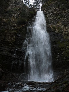
WRaysko Praskalo, 124.5 m in height, is the highest waterfall in Bulgaria and the Balkan Peninsula. It is situated under Botev Peak in the central section of the Balkan Mountains and is part of the Dzhendema Reserve of the Central Balkan National Park. The nearest town is Kalofer, at 11 km to the south.
 W
WThe Rose Valley is a region in Bulgaria located just south of the Balkan Mountains and the eastern part of the lower Sredna Gora chain to the south. Geologically, it consists of two river valleys, those of the Stryama to the west and the Tundzha to the east.
 W
WThe Rositsa is a river in central northern Bulgaria, the most important tributary of the Yantra. It is 148.5 kilometres (92 mi) long and has a drainage basin of 2,260 square kilometres (873 sq mi). Its ancient name was Lyginus.
 W
WThe Sazliyka or Rakitnitsa is a river in southeastern Bulgaria, a left tributary of the Maritsa. It originates in the Sarnena Sredna Gora mountains. In its upper course until Radnevo, it is also known as the Rakitnitsa or Syuyutliyka. The river is 121.7 kilometres in length and has a drainage basin of 3,366 square kilometres. Its average discharge at Galabovo is 17 cubic metres per second. The Galabovo Reservoir is located along the river.
 W
WThe Shirokolashka is a river of Plovdiv Province, Bulgaria. It is a tributary of the Vacha River. Along the river are villages such as Shiroka Laka with "typically Rodopean stone houses with small windows, high chimneys and hidden trapdoors."
 W
WSredna Gora is a mountain range in central Bulgaria, situated south of and parallel to the Balkan mountain range and extending from the Iskar River to the west and the elbow of Tundzha north of Yambol to the east. Sredna Gora is 285 km long, reaching 50 km at its greatest width. Its highest peak is Golyam Bogdan at 1,604 m (5,262 ft). It is part of the Srednogorie mountain chain system, together with Vitosha, Plana (mountain), Lyulin Mountain, Greben (mountain), Viskyar Mountain, etc.
 W
WThe Stryama is a river in southern Bulgaria, an important left tributary of the Maritsa. The river is 98.7 km long and has a drainage basin of 1,490 km².
 W
WThe Upper Thracian Plain constitutes the northern part of the historical region of Thrace. It is located in southern Bulgaria, between Sredna Gora mountains to the north and west, a secondary mountain chain parallel to the main Balkan Mountains; the Rhodopes, Sakar and Strandzha to the south; and the Black Sea to the east. A fertile agricultural region, the Upper Thracian Plain proper has an area of 16,032 square kilometres (6,190 sq mi) and an average elevation of 168 metres (551 ft). The plain is part of Northern Thrace. The climate is transitional continental. The highest temperature recorded in Bulgaria occurred here: it was 45.2 °C (113.4 °F) at Sadovo in 1916. The precipitation is 550 millimetres (22 in) a year. Important rivers are the Maritsa and its tributaries, Arda, Tundzha, Stryama, Topolnitsa, and Vacha. Important cities include Plovdiv, Burgas, Stara Zagora, Pazardzhik, Asenovgrad, Haskovo, Yambol and Sliven.
 W
WThe Vacha is a river in south Bulgaria, one of the main right tributaries of the Maritsa. It is 104 km long and is formed by the confluence of the rivers Chairdere and Buynovska reka. Shirokolashka is another tributary.